Apremont, Ardennes
Apremont is a commune in the department of Ardennes in the Grand Est region of northern France.
Apremont | |
|---|---|
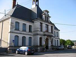 The town hall in Apremont | |
.svg.png) Coat of arms | |
Location of Apremont 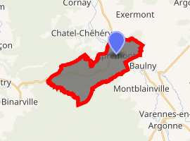
| |
 Apremont  Apremont | |
| Coordinates: 49°16′11″N 4°59′10″E | |
| Country | France |
| Region | Grand Est |
| Department | Ardennes |
| Arrondissement | Vouziers |
| Canton | Attigny |
| Intercommunality | Argonne Ardennaise |
| Government | |
| • Mayor (2008–2020) | Suzanne Raulin |
| Area 1 | 12.86 km2 (4.97 sq mi) |
| Population (2017-01-01)[1] | 117 |
| • Density | 9.1/km2 (24/sq mi) |
| Time zone | UTC+01:00 (CET) |
| • Summer (DST) | UTC+02:00 (CEST) |
| INSEE/Postal code | 08017 /08250 |
| Elevation | 137–247 m (449–810 ft) |
| 1 French Land Register data, which excludes lakes, ponds, glaciers > 1 km2 (0.386 sq mi or 247 acres) and river estuaries. | |
Geography
Apremont is located some 40 km north-west of Verdun, 6 km north-west of Varennes-en-Argonne, and 5 km south-east of Fléville. The south-western border of the commune is the border between the departments of Ardennes and Marne while the south-eastern border is the border between Ardennes and Meuse departments. Access to the commune is by the D946 road from Fléville in the north-west passing through the eastern part of the commune and continuing to Varennes-en-Argonne. Access to the village is by the D242 running off the D946. There are also the D42 road from Chatel-Chéhéry to the north to the village and the D442 from the village west to the commune border where it becomes the D66 and continues to join the D63. More than half of the commune is heavily forested in the west while the smaller eastern portion is farmland.[2]
The Aire river flows through the commune from west to east near the village and forms part of the northern border of the commune. The Ruisseau de Chaudron flows from the north-east into the Aire.[2]
Neighbouring communes and villages[2]
Places adjacent to Apremont, Ardennes | |
|---|---|
History
On April 18, 1918 French and American troops fought German forces near the town. Many participants were from Massachusetts and there is a park in Westfield, Massachusetts to honor those who fought in the battle.[3][4] In October 1918 this town was the site of a battle between the U.S. Army's 28th (Pennsylvania) Division and German forces.
Administration
List of Successive Mayors[5]
| From | To | Name | Party | Position |
|---|---|---|---|---|
| 2001 | 2008 | Christophe Rogie | ||
| 2008 | 2020 | Suzanne Raulin |
(Not all data is known)
Demography
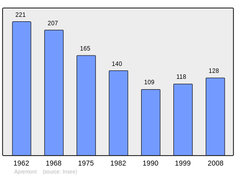
In 2009 the commune had 128 inhabitants. The evolution of the number of inhabitants is known from the population censuses conducted in the commune since 1793. From the 21st century, a census of communes with fewer than 10,000 inhabitants is held every five years, unlike larger towns that have a sample survey every year.[Note 1]
| 1793 | 1800 | 1806 | 1821 | 1831 | 1836 | 1841 | 1846 | 1851 |
|---|---|---|---|---|---|---|---|---|
| 467 | 550 | 528 | 547 | 550 | 579 | 644 | 672 | 650 |
| 1856 | 1861 | 1866 | 1872 | 1876 | 1881 | 1886 | 1891 | 1896 |
|---|---|---|---|---|---|---|---|---|
| - | - | 698 | 682 | 729 | 683 | 660 | 662 | 677 |
| 1901 | 1906 | 1911 | 1921 | 1926 | 1931 | 1936 | 1946 | 1954 |
|---|---|---|---|---|---|---|---|---|
| 629 | 624 | 648 | 183 | 318 | 275 | 306 | 234 | 224 |
| 1962 | 1968 | 1975 | 1982 | 1990 | 1999 | 2006 | 2009 | - |
|---|---|---|---|---|---|---|---|---|
| 221 | 207 | 165 | 140 | 109 | 118 | 128 | 128 | - |
See also
External links
- Apremont on the old National Geographic Institute website (in French)
- Apremont on Lion1906
- Apremont on Google Maps
- Apremont on Géoportail, National Geographic Institute (IGN) website (in French)
- Apremont on the 1750 Cassini Map
- Apremont on the INSEE website (in French)
- INSEE (in French)
Notes and references
Notes
- At the beginning of the 21st century, the methods of identification have been modified by Law No. 2002-276 of 27 February 2002 Archived 6 March 2016 at the Wayback Machine, the so-called "law of local democracy" and in particular Title V "census operations" allows, after a transitional period running from 2004 to 2008, the annual publication of the legal population of the different French administrative districts. For communes with a population greater than 10,000 inhabitants, a sample survey is conducted annually, the entire territory of these communes is taken into account at the end of the period of five years. The first "legal population" after 1999 under this new law came into force on 1 January 2009 and was based on the census of 2006.
References
| Wikimedia Commons has media related to Apremont, Ardennes. |