Arnicourt
Arnicourt is a commune in the Ardennes department in the Grand Est region of northern France.
Arnicourt | |
|---|---|
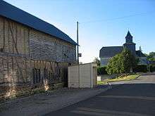
_city_limit_sign.JPG) Entrance to the village | |
Location of Arnicourt 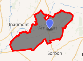
| |
 Arnicourt  Arnicourt | |
| Coordinates: 49°33′20″N 4°21′00″E | |
| Country | France |
| Region | Grand Est |
| Department | Ardennes |
| Arrondissement | Rethel |
| Canton | Rethel |
| Intercommunality | CC Pays Rethélois |
| Government | |
| • Mayor (2014–2020) | Alain Samyn |
| Area 1 | 8.33 km2 (3.22 sq mi) |
| Population (2017-01-01)[1] | 157 |
| • Density | 19/km2 (49/sq mi) |
| Time zone | UTC+01:00 (CET) |
| • Summer (DST) | UTC+02:00 (CEST) |
| INSEE/Postal code | 08021 /08300 |
| Elevation | 72–147 m (236–482 ft) (avg. 106 m or 348 ft) |
| 1 French Land Register data, which excludes lakes, ponds, glaciers > 1 km2 (0.386 sq mi or 247 acres) and river estuaries. | |
Geography
Arnicourt is located some 6 km north by north-west of Rethel and 8 km south-west of Novion-Porcien. Access to the commune is by the D10 road from Sorbon in the south passing through the commune and the village continuing to Sery in the north. The commune is entirely farmland with a small patch of forest in the north.[2]
The Plumion river flows through the north of the commune from north to south-west joining the Rayee on the south-western border. The Rayee continues south-west forming a small part of the south-western border.[2]
Neighbouring communes and villages[2]
Places adjacent to Arnicourt | |
|---|---|
Administration
_monument_aux_morts.JPG)
List of Successive Mayors[3]
| From | To | Name | Party | Position |
|---|---|---|---|---|
| 2001 | 2020 | Alain Samyn |
(Not all data is known)
Demography
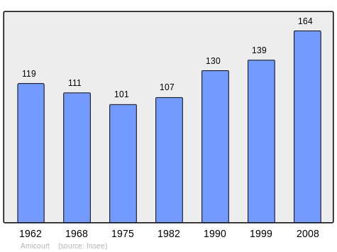
In 2009 the commune had 164 inhabitants. The evolution of the number of inhabitants is known from the population censuses conducted in the commune since 1793. From the 21st century, a census of communes with fewer than 10,000 inhabitants is held every five years, unlike larger towns that have a sample survey every year.[Note 1]
| 1793 | 1800 | 1806 | 1821 | 1831 | 1836 | 1841 | 1846 | 1851 |
|---|---|---|---|---|---|---|---|---|
| 365 | 357 | 384 | 390 | 399 | 419 | 423 | 418 | 422 |
| 1856 | 1861 | 1866 | 1872 | 1876 | 1881 | 1886 | 1891 | 1896 |
|---|---|---|---|---|---|---|---|---|
| - | - | 418 | 400 | 354 | 354 | 335 | 315 | 285 |
| 1901 | 1906 | 1911 | 1921 | 1926 | 1931 | 1936 | 1946 | 1954 |
|---|---|---|---|---|---|---|---|---|
| 279 | 256 | 209 | 159 | 165 | 166 | 156 | 99 | 138 |
| 1962 | 1968 | 1975 | 1982 | 1990 | 1999 | 2006 | 2009 | - |
|---|---|---|---|---|---|---|---|---|
| 119 | 111 | 101 | 107 | 130 | 139 | 154 | 164 | - |
Sites and monuments
- The Church of Saint-Médard.
- The Chateau of Arnicourt (18th century) is registered as an historical monument.

_%C3%A9glise.JPG) Church of Saint-Médard
Church of Saint-Médard_croix.JPG) Cross
Cross Chateau of Arnicourt
Notable people linked to the commune
- Gérard Darrieu (1925–2004), actor.
See also
External links
- Arnicourt on the National Geographic Institute website (in French)
- Arnicourt on Lion1906
- Arnicourt on Google Maps
- Arnicourt on Géoportail, National Geographic Institute (IGN) website (in French)
- Arnicourt on the 1750 Cassini Map
- Arnicourt on the INSEE website (in French)
- INSEE (in French)
Notes and references
Notes
- At the beginning of the 21st century, the methods of identification have been modified by Law No. 2002-276 of 27 February 2002 Archived 6 March 2016 at the Wayback Machine, the so-called "law of local democracy" and in particular Title V "census operations" allows, after a transitional period running from 2004 to 2008, the annual publication of the legal population of the different French administrative districts. For communes with a population greater than 10,000 inhabitants, a sample survey is conducted annually, the entire territory of these communes is taken into account at the end of the period of five years. The first "legal population" after 1999 under this new law came into force on 1 January 2009 and was based on the census of 2006.
References
- "Populations légales 2017". INSEE. Retrieved 6 January 2020.
- Google Maps
- List of Mayors of France (in French)
- Ministry of Culture, Mérimée PA08000006 Church (in French)
| Wikimedia Commons has media related to Arnicourt. |