Auboncourt-Vauzelles
Auboncourt-Vauzelles is a commune in the Ardennes department in the Grand Est region of north-eastern France.
Auboncourt-Vauzelles | |
|---|---|
_vue_du_village_d'Auboncourt.JPG) View of the Village | |
Location of Auboncourt-Vauzelles 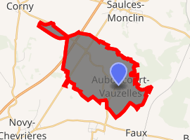
| |
 Auboncourt-Vauzelles  Auboncourt-Vauzelles | |
| Coordinates: 49°33′10″N 4°29′38″E | |
| Country | France |
| Region | Grand Est |
| Department | Ardennes |
| Arrondissement | Rethel |
| Canton | Signy-l'Abbaye |
| Intercommunality | CC Crêtes Préardennaises |
| Government | |
| • Mayor (2014-2020) | Benoît Carier |
| Area 1 | 5.4 km2 (2.1 sq mi) |
| Population (2017-01-01)[1] | 100 |
| • Density | 19/km2 (48/sq mi) |
| Time zone | UTC+01:00 (CET) |
| • Summer (DST) | UTC+02:00 (CEST) |
| INSEE/Postal code | 08027 /08270 |
| Elevation | 86–127 m (282–417 ft) (avg. 98 m or 322 ft) |
| 1 French Land Register data, which excludes lakes, ponds, glaciers > 1 km2 (0.386 sq mi or 247 acres) and river estuaries. | |
Geography
_city_limit_sign.JPG)
Auboncourt-Vauzelles is located some 38 km south-west of Charleville-Mézières and 16 km north-east of Rethel. The A34 autoroute passes through the north-west of the commune but the nearest exit is Exit 14 some 6 km north of the commune. Access to the commune is by the D 951 road from Novy-Chevrières in the south-west which passes through the north-west of the commune and the hamlet of Vauzelles as it goes north to join the A34 autoroute at Exit 14. The D 14 road comes from Corny-Machéroménil in the north-west which passes through Vauzelles and the centre of the commune before continuing south to Faux. Access to the village is by small roads that run off the D 14 - the Chemin d'Auboncourt and the Chemin de la Fontaine. The commune is entirely farmland except for the fringe of the Bois d'Auboncourt forest in the north-east.[2]
The Ruisseau de Saulces flows through the east of the commune and the village from north to south-east and continues to join the Aisne south of Amagne.[2]
Neighbouring communes and villages[2]
Places adjacent to Auboncourt-Vauzelles | ||||||||||
|---|---|---|---|---|---|---|---|---|---|---|
| ||||||||||
Administration
_mairie.JPG)
_monument_aux_morts.JPG)
List of Successive Mayors[3]
| From | To | Name | Party | Position |
|---|---|---|---|---|
| 1995 | 2008 | Michel Hot | ||
| 2008 | 2012 | Armelle Malherbe | ||
| 2012 | 2020 | Benoît Carier |
(Not all data is known)
Demography
_Lavoir.JPG)
_%C3%A9glise_(2).JPG)
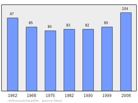
In 2010 the commune had 102 inhabitants. The evolution of the number of inhabitants is known from the population censuses conducted in the commune since 1793. From the 21st century, a census of communes with fewer than 10,000 inhabitants is held every five years, unlike larger towns that have a sample survey every year.[Note 1]
| 1793 | 1800 | 1806 | 1821 | 1831 | 1836 | 1841 | 1846 | 1851 |
|---|---|---|---|---|---|---|---|---|
| 364 | 153 | 159 | 164 | 267 | 288 | 299 | 281 | 273 |
| 1856 | 1861 | 1866 | 1872 | 1876 | 1881 | 1886 | 1891 | 1896 |
|---|---|---|---|---|---|---|---|---|
| - | - | 258 | 270 | 272 | 245 | 250 | 267 | 240 |
| 1901 | 1906 | 1911 | 1921 | 1926 | 1931 | 1936 | 1946 | 1954 |
|---|---|---|---|---|---|---|---|---|
| 229 | 201 | 186 | 129 | 119 | 120 | 111 | 114 | 109 |
| 1962 | 1968 | 1975 | 1982 | 1990 | 1999 | 2006 | 2010 | - |
|---|---|---|---|---|---|---|---|---|
| 97 | 85 | 80 | 82 | 82 | 85 | 103 | 102 | - |
See also
External links
- Auboncourt-Vauzelles on the old IGN website (in French)
- Auboncourt-Vauzelles on Géoportail, National Geographic Institute (IGN) website (in French)
- Auboncourt and Vauzelles on the 1750 Cassini Map
- Auboncourt-Vauzelles on the INSEE website (in French)
Notes and references
Notes
- At the beginning of the 21st century, the methods of identification have been modified by Law No. 2002-276 of 27 February 2002 Archived 6 March 2016 at the Wayback Machine, the so-called "law of local democracy" and in particular Title V "census operations" allows, after a transitional period running from 2004 to 2008, the annual publication of the legal population of the different French administrative districts. For communes with a population greater than 10,000 inhabitants, a sample survey is conducted annually, the entire territory of these communes is taken into account at the end of the period of five years. The first "legal population" after 1999 under this new law came into force on 1 January 2009 and was based on the census of 2006.
References
- "Populations légales 2017". INSEE. Retrieved 6 January 2020.
- Google Maps
- List of Mayors of France (in French)
| Wikimedia Commons has media related to Auboncourt-Vauzelles. |
| Authority control |
|
|---|