Bandar Lampung
Bandar Lampung (Lampungese: ![]()
Bandar Lampung | |
|---|---|
| City of Bandar Lampung Kota Bandar Lampung | |
    Clockwise: Adipura Monument, Aerial view of Southern Bandar Lampung, Tanjung Karang Station, Siger Monument | |
 Seal | |
| Motto(s): Ragom Gawi (Language and Culture) | |
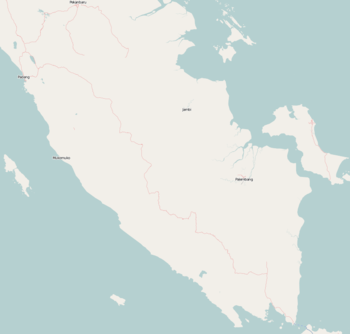
 Location within Lampung | |
| Coordinates: 5°27′0″S 105°16′0″E | |
| Country | Indonesia |
| Province | Lampung |
| Founded | June 17, 1682 |
| Government | |
| • Type | City |
| • Mayor | Herman Hasanusi |
| • Vice Mayor | Muhammad Yusuf Kohar |
| Area | |
| • Total | 169.21 km2 (65.33 sq mi) |
| • Land | 118.50 km2 (45.75 sq mi) |
| • Water | 23.75 km2 (9.17 sq mi) |
| Elevation | 15 m (49 ft) |
| Population (2017) | 1,015,910 |
| Human Development Index | |
| • HDI (2007) | 0.742 |
| Time zone | UTC+7 (Indonesia Western Time) |
| Postcodes | 35111 to 35246[2] |
| Area code | (+62) 721 |
| Website | bandarlampungkota |

The city proper and South Lampung Regency (which borders the city on its northern and eastern sides) are major transmigrasi recipients; in testimony thereof, it has become the third-densest city in Sumatra, after Medan and Palembang. The city's area is about 169.21 km², with an estimated population of 1.015.910[4] as of 2017.
History
Early history
A report by the Banten regent William Craft to Governor-General Cornelis Speelman states that, on the basis of a description provided by Pangeran Aria Dipati Ningrat on the 17th June 1682, "Lampung-Telokbetong at the edge of the sea is the seat of power of a Dipati Temenggung Nata Negara, with power over three thousand people". This date would later be adopted by the city administration as its official founding date.[5]
Dutch East Indies
Under the Dutch colonial administration, 1912 Staatsblad 462 codified the city as being part and parcel of the Onderafdeling Telokbetong, composed of present-day Teluk Betung and its environs. The Onderafdeling's capital was Tanjung Karang, whilst Teluk Betung itself served as the seat of government for the Karesidenan Lampung.[5]
Under Japanese occupation
During the Japanese colonial era, present-day Bandar Lampung was administered as a city (市, shi), led by a Japanese mayor (市長, shicho) who was assisted by an Indonesian deputy mayor (副市長, fuku-shicho).[5]
Post-Independence
Tanjung Karang and Teluk Betung initially fell under the jurisdiction of South Lampung Regency, until a 1948 law consolidated the two and elevated them to independent city status.[5]
Administrative divisions
In 2010, the city consisted of thirteen districts (kecamatan), tabulated below with their populations at the 2010 Census:[6]
|
|
|
Since 2010, seven additional districts have been created by the splitting of existing districts, bringing the total to twenty districts. The new districts are Bumi Waras, Enggal, Kedamaian, Labuhan Ratu, Langkapura, Telukbetung Timur (East Telukbetung) and Way Halim.

Climate
Bandar Lampung has a tropical rainforest climate (Af) with heavy rainfall year-round. Rain gets noticeably heavier from November to April.
| Climate data for Bandar Lampung | |||||||||||||
|---|---|---|---|---|---|---|---|---|---|---|---|---|---|
| Month | Jan | Feb | Mar | Apr | May | Jun | Jul | Aug | Sep | Oct | Nov | Dec | Year |
| Average high °C (°F) | 30.3 (86.5) |
31.0 (87.8) |
31.6 (88.9) |
32.0 (89.6) |
31.9 (89.4) |
31.7 (89.1) |
31.3 (88.3) |
31.4 (88.5) |
31.4 (88.5) |
32.0 (89.6) |
32.0 (89.6) |
31.1 (88.0) |
31.5 (88.7) |
| Daily mean °C (°F) | 26.4 (79.5) |
26.7 (80.1) |
27.2 (81.0) |
27.3 (81.1) |
27.2 (81.0) |
26.8 (80.2) |
26.6 (79.9) |
26.6 (79.9) |
26.7 (80.1) |
27.2 (81.0) |
27.3 (81.1) |
26.9 (80.4) |
26.9 (80.4) |
| Average low °C (°F) | 22.6 (72.7) |
22.5 (72.5) |
22.8 (73.0) |
22.7 (72.9) |
22.5 (72.5) |
22.0 (71.6) |
21.9 (71.4) |
21.8 (71.2) |
22.1 (71.8) |
22.4 (72.3) |
22.7 (72.9) |
22.7 (72.9) |
22.4 (72.3) |
| Average precipitation mm (inches) | 280 (11.0) |
281 (11.1) |
255 (10.0) |
175 (6.9) |
135 (5.3) |
119 (4.7) |
100 (3.9) |
121 (4.8) |
118 (4.6) |
139 (5.5) |
149 (5.9) |
250 (9.8) |
2,122 (83.5) |
| Source: [7] | |||||||||||||
Transportation
Air
Bandar Lampung is served by Radin Inten II Airport (TKG), in the neighbouring county of South Lampung. The airport can be accessed by public transportation, such as bus and mini bus.
Road transport


Bandar Lampung has several road transportation alternatives. The most popular is a minibus called angkot, an abbreviation from Angkutan Kota (literally translated as City Transportation). They serve routes throughout the city, operated privately and cheaply. Usually, an angkot covers some area between Tanjung Karang (heart of Bandar Lampung) and an urban area. Currently, routes covered are Tanjung Karang - Garuntang, Tanjung Karang - Teluk Betung, Tanjung Karang - Rajabasa, Tanjung Karang - Sukarame, Tanjung Karang - Langkapura and many more.
Bandarlampung Transportation Office has announced that in October 2011 will serve two of seven routes planned by Bus Rapid Transit — the Rajabasa-Sukaraja and Sukaraja-Korpri housing complex in Sukarame.[8]
Rail transport
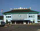
Tanjung Karang Station in Bandar Lampung is the terminus of the railway service from Palembang, although the railway track continues all the way until Panjang harbor and Tarahan coal offloading point. Many express trains connecting this city and Palembang, including Limex Sriwijaya and Rajabasa Express.
Education
In 2009, Bandar Lampung has a literacy rate of 94.3%,[9] slightly increased from 2005 which was 93.5%. However, the high school participation rate kept decreasing from 69.2% (2007) down to 61.4% (2009).[10] On the other hand, high school participation rate in Indonesia rose from 54.6% in 2007, to 55.8% in 2010.[11]

There are some notable high schools and universities in Bandar Lampung such as SMP Negeri 2 Bandar Lampung (public), SMP Negeri 1 Bandar Lampung (public), SMA Negeri 9 Bandar Lampung (public, known as Smalan), SMA Negeri 1 Bandar Lampung (public, known as Smansa), SMA Al-Kautsar Bandar Lampung (private), SMA Fransiskus Bandar Lampung (private), SMA Xaverius Pahoman (a Catholic private school teaching students from kindergarten to high school, locally known as Xavepa), Lampung University (public, locally known as Unila), Bandar Lampung University (private, locally known as UBL: Universitas Bandar Lampung),Muhammadiyah University of Lampung (known as UML: Universitas Muhammadiyah Lampung and Malahayati University (private). In March 2011, Unila already had 70,866 alumni.[12]
Sister cities
Bandar Lampung is twinned with:


References
- "Indeks Pembangunan Manusia 2007" (PDF). Badan Pusat Statistik Provinsi Lampung. 2007. Archived from the original (PDF) on 26 March 2012. Retrieved 3 July 2011.
- https://kodepos.nomor.net/_kodepos.php?_i=kecamatan-kodepos&sby=010000&daerah=Kota&jobs=Bandar%20Lampung
- "Peraturan Pemerintah Nomor 24 Tahun 1983". President of Republic Indonesia. 1983. Retrieved 5 July 2011.
- Kota Bandar Lampung Dalam Angka Tahun 2018 (BPS)
- "PORTAL Berita Resmi Pemerintahan Kota Bandar Lampung". bandarlampungkota.go.id. Retrieved 3 June 2020.
- Biro Pusat Statistik, Jakarta, 2011.
- https://en.climate-data.org/location/4812
- "Bandarlampung to unveil BRT as passenger-friendly transport". 22 September 2011.
- "Angka Melek Huruf Penduduk berumur 15 tahun ke atas menurut Kabupaten/Kota 2005-2009" (PDF). Badan Pusat Statistik Provinsi Lampung, Indonesia. 2010. Archived from the original (PDF) on 26 March 2012. Retrieved 3 July 2011.
- "Angka Partisipasi Sekolah menurut Kabupaten/Kota" (PDF). Badan Pusat Statistik Provinsi Lampung, Indonesia. 2010. Archived from the original (PDF) on 26 March 2012. Retrieved 3 July 2011.
- "Indikator Pendidikan Tahun 1994-2010". Badan Pusat Statistik. 2010. Archived from the original on 17 July 2011. Retrieved 3 July 2011.
- "WISUDA: Unila Lahirkan 1.403 Sarjana". Lampung Post. 16 March 2011. Retrieved 3 July 2011.
External links
| Wikivoyage has a travel guide for Bandar Lampung. |
| Wikimedia Commons has media related to Bandar Lampung. |
- Official Lampung Provincial Website (in Indonesian)
- Official Government Kota Bandar Lampung Website (in Indonesian)
- Trip to Bandar Lampung (in Japanese)
Regencies and cities of Lampung | ||
|---|---|---|
Capital: Bandar Lampung | ||
| Regencies | ||
| Cities |
| |
Articles Related to Bandar Lampung | |||||||||||
|---|---|---|---|---|---|---|---|---|---|---|---|
| |||||||||||
| Authority control |
|
|---|