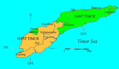
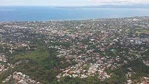
Kupang
Kupang (Indonesian: Kota Kupang, Indonesian pronunciation: [ˈkupaŋ] ; Dutch spelling: Koepang) is the capital of the Indonesian province of East Nusa Tenggara, and had an estimated population in 2019 of 434,972.[2] It is the biggest city and port on the island of Timor. Kupang is a part of the Timor Leste–Indonesia–Australia Growth Triangle[3] free trade zone.
Kupang | |
|---|---|
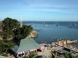 Kupang lighthouse and Sail Indonesia anchorage | |
 Seal | |
| Motto(s): Kupang Kota KASIH | |
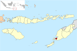 Location within East Nusa Tenggara | |
 Kupang 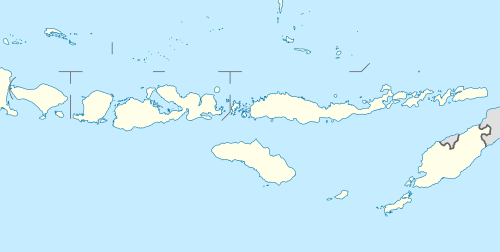 Kupang Kupang (Lesser Sunda Islands)  Kupang Kupang (Indonesia) | |
| Coordinates: 10°09′48″S 123°34′40″E | |
| Country | |
| Province | |
| Founded | 1886 |
| Government | |
| • Mayor | Jefri Riwu Kore |
| • Vice Mayor | Hermanus Man |
| Area | |
| • Total | 180.27 km2 (69.60 sq mi) |
| Elevation | 62 m (203 ft) |
| Population (2019)[2] | |
| • Total | 434,972 |
| • Density | 2,400/km2 (6,200/sq mi) |
| Time zone | UTC+8 (Indonesia Central Time) |
| Area code | (+62) 380 |
| Vehicle registration | DH |
| Website | kupangkota |
History
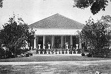
Kupang was an important port and trading point during the Portuguese and Dutch colonial eras. There are ruins and remnant signs of the colonial presence in the city.
Representatives of the Dutch East India Company (VOC) approached Kupang in 1613 after having conquered the Portuguese fort on Solor. At this time the place and its hinterland was governed by a raja of the Helong tribe which claimed descent from Ceram in Maluku. Kupang was well situated for strategic control over parts of Timor, since it was possible to monitor shipping activities to the south coast of the island. Moreover, the Koinino River provided fresh water for the inhabitants. A VOC-Helong agreement was made, but due to the lack of VOC commitment on Timor, Kupang was later influenced by the Portuguese mestizo population of Flores, the Topasses. A Portuguese stronghold was established by the 1640s. However, the VOC was firmly established on Solor in 1646, and renewed contacts with the local raja.[4] In January 1653 a Dutch fortification, Fort Concordia, was built on a height to the left of the river estuary. Kupang became the base of the Dutch struggle against the Portuguese. After a series of Dutch defeats in 1655, 1656 and 1657, large refugee groups from the VOC allies Sonbai and Amabi settled in the vicinity of Kupang in 1658 and formed small kingdoms on land that traditionally belonged to the Helong. They were followed by two other groups, Amfoan (1683) and Taebenu (1688). The Helong raja remained the "lord of the land" (tuan tanah) but was closely dependent on the VOC authorities. Apart from the old Helong territory, Timor was largely dominated by the Portuguese up to 1749.[5]
The Dutch set up a European administration with a chief executive (opperhoofd) and a council. Affairs with the indigenous populations were regulated through regular meetings (vergaderingen). The Kupang administration handled affairs with the VOC-allied islands Rote, Savu and Solor. Chinese traders and artisans settled by the early 18th century and soon became indispensable for the economic life. The town area was also settled by various indigenous groups from the region, and by mardijkers who were non-whites under Dutch jurisdiction. In 1752 the population was 827 Christians and an unspecified number of non-Christians.[6] The political importance of Kupang on a Timor-wide level increased greatly in 1749 when the Topasses were decisively defeated by the Dutch and their allies, which led to the extension of VOC influence over wide areas of western and central Timor. Nevertheless, some of this influence contracted after 1761 due to incompetence and inaction on the part of the colonial administration.
Kupang was the final destination of William Bligh who was set adrift in an open boat following the Mutiny on the Bounty (1789). The mutiny took place about 30 nautical miles (56 km) from Tofua in the Tonga islands. Lt William Bligh navigated the overcrowded 23 foot (7 m) open launch on an epic 41-day voyage first to Tofua and then to the West Timor city of Kupang equipped only with a quadrant, pocket watch and a compass — but no charts to navigate from.[7] He recorded the distance as 3,618 nautical miles (6710 km). He passed through the difficult Torres Strait along the way and landed on 14 June. The only casualty of his voyage was a crewman named John Norton who was stoned to death by the natives of Tofua, the first island they tried to land on.[8] News of the journey of Captain Bligh inspired the escape of a party of convicts from the penal colony at Sydney Cove, Australia. A group of nine convicts and two children, led by William Bryant, stole a small uncovered government boat and escaped from Port Jackson, Australia.[9] Ten weeks later, they arrived at Kupang, having covered 3,254 nautical miles (6,026 km).[10]
As a consequence of the occupation of the Netherlands at the hands of the French revolutionary armies in 1795, the VOC possessions in East India were attacked by British forces. Kupang was assaulted in 1797. The British were eventually expelled although the town was reduced to rubble. A new British attack was likewise defeated in 1811. After the British occupation of Java, Kupang finally surrendered in January 1812. The British returned the town to the Dutch in 1816. The political strongman in the early 19th century was Jacobus Arnoldus Hazaart who governed Dutch Timor as Resident in 1810–12, 1814–18 and 1819–32 and handled matters without much interference from the colonial government in Batavia.[11] During his time the Christian mission made a deeper impact through the efforts of the missionary Reint LeBruyn (1799-1829). The town was opened to foreign trade in 1825 and fees were abolished three years later. Kupang was often visited by whalers from Britain and North America. However, the relocation of whale hunting areas made Kupang a less lively place in the late 19th century, although it was a free port after 1866.[12] The five small kingdoms that surrounded the town area (the Helong kingdom of Kupang, Sonbai Kecil, Amabi, Taebenu and Funai) were merged into the zelfbesturend landschap (self-ruling territory) Kupang in 1917, but in spite of the name it did not include the town itself. From 1918 to 1955 it was governed by the Nisnoni family, a branch of the Sonbai Dynasty.[13]
In the early twentieth century, the city was used for landing and refueling by long distance airplane flights between Europe and Australia. It was occupied by the Japanese in 1942–1945, and much of the old town was destroyed by allied bombing. During the time of the Indonesian revolution 1945-1949 there was nationalist agitation in Kupang, but no actual fighting. Kupang was part of the colonial pseudo-state East Indonesia that was set up by the Dutch, and the town area was included in the zelfbesturend landschap Kupang.[14] The latter was phased out after the achievement of independence. Kupang was an important location during the conflict in East Timor, for the Indonesian military, as well as the militias. The camps around Kupang were also of significant impact on the city.
In 1967, the city was made the seat of the Diocese of Kupang. In 1989 the diocese was elevated to become the Archdiocese of Kupang.
Climate
Kupang's climate is a tropical wet and dry climate (Aw) by the Köppen climate classification. Unlike many cities outside Indonesia with this climate, Kupang's temperature varies a little between the hotter summer season (October to March) and the cooler winter season (April to September). October is the hottest month (average temperature 28.8 °C /83.8 °F) and July the coolest (average temperature 26.1 °C /79.0 °F). The city has a distinct wet season and dry season. January is the wettest month (precipitation total 386 millimetres/15.2 in). August and September are the driest months (precipitation total 2 millimetres /0.079 in)
| Climate data for Kupang, East Timor, Indonesia (1961-1975) | |||||||||||||
|---|---|---|---|---|---|---|---|---|---|---|---|---|---|
| Month | Jan | Feb | Mar | Apr | May | Jun | Jul | Aug | Sep | Oct | Nov | Dec | Year |
| Record high °C (°F) | 35.0 (95.0) |
34.4 (93.9) |
35.6 (96.1) |
36.1 (97.0) |
35.6 (96.1) |
34.4 (93.9) |
35.0 (95.0) |
36.7 (98.1) |
37.2 (99.0) |
38.3 (100.9) |
38.3 (100.9) |
36.7 (98.1) |
38.3 (100.9) |
| Average high °C (°F) | 30.1 (86.2) |
30.0 (86.0) |
31.1 (88.0) |
32.4 (90.3) |
32.3 (90.1) |
31.4 (88.5) |
31.3 (88.3) |
32.5 (90.5) |
33.4 (92.1) |
33.8 (92.8) |
33.1 (91.6) |
31.4 (88.5) |
31.9 (89.4) |
| Daily mean °C (°F) | 26.9 (80.4) |
26.6 (79.9) |
27.2 (81.0) |
27.7 (81.9) |
27.4 (81.3) |
26.2 (79.2) |
26.1 (79.0) |
26.7 (80.1) |
27.7 (81.9) |
28.8 (83.8) |
28.7 (83.7) |
27.6 (81.7) |
27.3 (81.1) |
| Average low °C (°F) | 23.8 (74.8) |
23.5 (74.3) |
23.3 (73.9) |
22.8 (73.0) |
22.3 (72.1) |
20.7 (69.3) |
20.2 (68.4) |
20.5 (68.9) |
21.2 (70.2) |
22.5 (72.5) |
23.6 (74.5) |
23.8 (74.8) |
22.4 (72.3) |
| Record low °C (°F) | 21.1 (70.0) |
20.0 (68.0) |
20.6 (69.1) |
17.2 (63.0) |
17.8 (64.0) |
15.6 (60.1) |
15.6 (60.1) |
15.6 (60.1) |
16.7 (62.1) |
18.3 (64.9) |
20.0 (68.0) |
21.1 (70.0) |
15.6 (60.1) |
| Average precipitation mm (inches) | 386 (15.2) |
347 (13.7) |
234 (9.2) |
65 (2.6) |
30 (1.2) |
10 (0.4) |
5 (0.2) |
2 (0.1) |
2 (0.1) |
17 (0.7) |
83 (3.3) |
232 (9.1) |
1,413 (55.8) |
| Average precipitation days (≥ 1.0 mm) | 18.1 | 15.5 | 13.2 | 5.0 | 2.5 | 1.2 | 0.8 | 0.3 | 0.3 | 1.3 | 6.9 | 14.7 | 79.8 |
| Average relative humidity (%) | 85 | 86 | 83 | 75 | 70 | 67 | 65 | 63 | 64 | 66 | 73 | 81 | 73 |
| Mean monthly sunshine hours | 189 | 195 | 223 | 267 | 276 | 276 | 288 | 304 | 306 | 288 | 264 | 205 | 3,081 |
| Source 1: Deutscher Wetterdienst[15] | |||||||||||||
| Source 2: Danish Meteorological Institute[16] | |||||||||||||
Demography
Kupang is a multi-ethnic city composed of the ethnic groups of West Timor, the nearby islands of Rote, Savu and Flores, a small ethnic Chinese community, and immigrants from Ambon and from other parts of Indonesia. Based on data from the Central Bureau of Statistics of Indonesia for 2019, the population of Kupang was 434,972.[2]
Government
The city of Kupang is, in administrative terms, a kota (city) which has the same status as a regency (kabupaten) within the Indonesian administrative system. The chief officers are the mayor and deputy mayor, elected officials who hold office for five years. The current mayor and deputy mayor are Jefri Riwu Kore and Harmanus Man who were sworn into office by the governor of the province of East Nusa Tenggara, Frans Lebu Raya, in Kupang on 1 August 2017. They will hold office for the period 2017–2022.[17]
Districts
In 2017 Kupang City was divided into 6 districts (kecamatan), tabulated below with their 2017 Census population.
| Name | Population Census 2017 |
|---|---|
| Alak | 63,229 |
| Maulafa | 79,581 |
| Oebobo | 100,149 |
| Kota Raja | 54,794 |
| Kelapa Lima | 80,260 |
| Kota Lama | 34,535 |
Economy
The formal sector of the manufacturing sector in the Kupang area is mainly based on the cement industry. The export and import of goods from the local port is also an important part of the regional economy. Local service sector activities (trading, transport, food and drinks) also employ significant numbers of people in the informal sector.
Fish Exports
Fish exports from East Nusa Tenggara are centralized through the Port of Fisheries in Tenau, Kupang. Japan, East Timor, United States, and Thailand are four fish export destinations.[18]
Sailing
Kupang is the first port of call for yachts in the annual Sail Indonesia[19] rally which starts in Darwin, Australia towards the end of July each year. In 2006 about 100 yachts from around the world took part in the rally. From Kupang yachts head north to Alor and then stop at various ports in Indonesia over a period of about three months ending up in Singapore.
Civil society organisations
Kupang City hosts some of the progressive civil society organisations such as Pikul Foundation, TF Indonesia and CIS Timor. Think tanks organisation also exist in the city and one of the leading think tank is the Institute of Resource Governance and Social Change.[20]
Transportation
Air
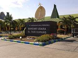
Kupang's El Tari Airport (formerly "Penfui Airport") serves domestic flights to several cities in Indonesia, as well as an international route to Dili, East Timor.
The airport previously operated direct flights to Darwin, Australia, but this was discontinued along with the Dili route in the 1990s, due to alleged human rights violations by the Indonesian Armed Forces in East Timor. The Kupang-Dili route was resumed on 15 December 2017, operated by Air Timor.
Sea
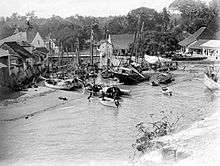
Kupang harbour is a harbour in Kupang that can serve both cargo and passenger ships. Passengers typically advance through Kupang to destinations such as Ruteng, Baa, Kalabahi and others. Currently the Commercial Port is located in Tenau and Bolok, which is a Kupang regency. Kupang Namosain is a natural sea port that is now laid out better. This port serves timber ships heading to Rote, Semau and areas around the city of Kupang. Previously the port was also used by fishermen to unload their catches. Kupang Harbor is an old sea port now berthing sailboats from abroad and has become a stopover in saling Indonesia from Darwin, Australia.
Land
Land transport system in Kupang is served by minibus transportation commonly called bemo.
Education
In 1962, the University of Nusa Cendana was established, and the city became important both in the field of education and also economically. Kupang is also the home of an private university, Artha Wacana Christian University, Widya Mandira Catholic University.
Tourism
Attractions
- Lasiana Beach
- Nostalgia Park
- Night Market[21]
See also
- List of colonial Residents of Dutch Timor
- History of Timor
References
- "Population of Kupang, Indonesia". Archived from the original on 18 June 2012. Retrieved 14 September 2012.
- "Penduduk Kota Kupang tahun 2019". BPS Kota Kupang (in Indonesian). 29 April 2020.
- "Boosting Growth through the Growth Triangle « Government of Timor-Leste". timor-leste.gov.tl.
- Arend de Roever, De jacht op sandelhout: De VOC en de tweedeling van Timor in de zeventiende eeuw (Zutphen 2002), pp. 105-255.
- Hans Hägerdal, Lords of the land, lords of the sea: Conflict and adaptation in early colonial Timor, 1600-1800 (Leiden 2012), pp. 199-309.
- Hans Hägerdal 2012, p. 254.
- "A Voyage to the South Sea". www.gutenberg.org. Retrieved 29 April 2020.
- Regarding the Mutineers, see: http://library.puc.edu/pitcairn/pitcairn/history.shtml
- T. Kenealy, Commonwealth of Thieves (Random House Australia 2005), p. 353.
- "A Voyage to the South Sea". www.gutenberg.org. Retrieved 29 April 2020.
- Steven Farram, "Jacobus Arnoldus Hazaart and the British interregnum in Netherlands Timor, 1812-1816", Bijdragen tot de Taal-, Land- en Volkenkunde 163-4 (2007), pp. 455-475.
- Hermann Fiedler, Die Insel Timor (Friedrichssegen 1929), p. 2.
- L.J. van Dijk, "De zelfbesturende landschappen in de Residentie Timor en Onderhoorigheden", Indische Gids 47 (1925).
- Steven Farram, From 'Timor Koepang' to 'Timor NTT': The political history of West Timor, 1901-1967 (PhD Thesis, Charles Darwin University 2004).
- "Klimatafel von Kupang / Insel Timor / Indonesien" (PDF). Federal Ministry of Transport and Digital Infrastructure. Retrieved 8 June 2016.
- "STATIONSNUMMER 97372" (PDF). Danish Meteorological Institute. Archived from the original on 16 January 2013. Retrieved 8 June 2016.CS1 maint: unfit url (link)
- Fointuna, Yemris (2 August 2012). "New Kupang mayor pledges pro-people policies". The Jakarta Post. Retrieved 26 January 2013.
- "NTT Ekspor Ikan ke Empat Negara". Victory News. 25 April 2012. Archived from the original on 5 February 2013. Retrieved 8 November 2012.
- http://www.sailindonesia.net/ Sail Indonesia
- IRGSC
- "Night Market".
External links
| Wikimedia Commons has media related to Kupang (city). |

Regencies and cities of East Nusa Tenggara | ||
|---|---|---|
Capital: Kupang | ||
| Regencies |  | |
| Cities | ||
| 2,000,000 and more | |
|---|---|
| 1,000,000–1,999,999 | |
| 500,000–999,999 | |
| 200,000–499,999 | |
| Authority control |
|
|---|