Yayladere
| Yayladere / XolXol | |
|---|---|
 Yayladere town | |
 Yayladere / XolXol | |
| Coordinates: 39°13′28″N 40°04′21″E / 39.22444°N 40.07250°ECoordinates: 39°13′28″N 40°04′21″E / 39.22444°N 40.07250°E | |
| Country | Turkey |
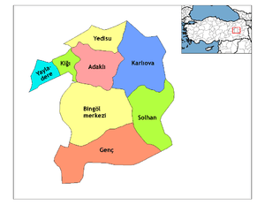
| Province | Bingöl |
| Government | |
| • Mayor | Sabri Akyürek (CHP) |
| • Kaymakam | Adem Ergül |
| Area[1] | |
| • District | 429.74 km2 (165.92 sq mi) |
| Population (2012)[2] | |
| • Urban | 1,249 |
| • District | 2,019 |
| • District density | 4.7/km2 (12/sq mi) |
| Post code | 12500 |
| Website | www.yayladere.bel.tr |
Yayladere (Old name: in Kurdish and Armenian -'Holhol /Xolxol) is a town and county of Bingöl Province in the Eastern Anatolia Region, it had previously been a sancak (district) of the province of Dersim. The county has an area of 430 km ² and is bordered on the west by Tunceli and Elazığ to the south. The Peri River forms the natural border to Elazig. The area is about 1,600 m above sea level. The mountains up to 2,800 m high. The two largest are the Sülbüs / Selbuz ( 2,884 m) and Sultan Mehmet / Taru. The local population is Kurdish with previous Armenian communities. The mayor is Sabri Akyürek (CHP). The district has twenty-six villages and eighty hamlets, most of the population are Alevi muslims, however in recent decades there has been a shift towards sunni Islam. There are 2,000 people living in the district as per 2007 estimates. It is known for its goat dishes.
References
- ↑ "Area of regions (including lakes), km²". Regional Statistics Database. Turkish Statistical Institute. 2002. Retrieved 2013-03-05.
- ↑ "Population of province/district centers and towns/villages by districts - 2012". Address Based Population Registration System (ABPRS) Database. Turkish Statistical Institute. Retrieved 2013-02-27.