Tunceli
| Tunceli | |
|---|---|
| Municipality | |
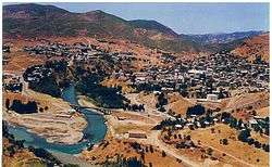 Tunceli in Munzur valley | |
 Tunceli Location in Turkey | |
| Coordinates: 39°06′N 39°33′E / 39.100°N 39.550°ECoordinates: 39°06′N 39°33′E / 39.100°N 39.550°E | |
| Country |
|
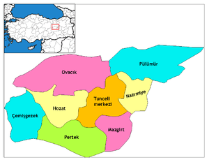
| Province | Tunceli Province |
| Government | |
| • Mayor | Mehmet Ali Bul (DBP) |
| Area[1] | |
| • District | 881.76 km2 (340.45 sq mi) |
| Elevation | 940 m (3,085 ft) |
| Population (2012)[2] | |
| • Urban | 31,469 |
| • District | 35,898 |
| • District density | 41/km2 (110/sq mi) |
| Time zone | UTC+2 (EET) |
| • Summer (DST) | UTC+3 (EEST) |
| Postal code | 62000 |
| Area code(s) | 0428 |
| Licence plate | 62 |
| Website | Website |
Tunceli (pronounced [tundʒeli]; Kurdish: Dêrsimê, Zazaki: Desim or Mamekiye) is a city in Turkey. It is the capital of Tunceli Province, located in the middle of Eastern Anatolia Region. Former names of Tunceli include Mamiki (from the Armenian: Mamikon), Kalan, and Dersim.[3]
Etymology
Tunceli, meaning "Iron hand" in Turkish was the name of the Turkish military operation to assimilate (turkify) the people by force.
Geography
Tunceli at 39°06′N 39°33′E / 39.100°N 39.550°E is situated just to the north of the intersection point of two rivers, Munzur and Pülümür, both flowing to south. The city is founded in the valley of Munzur which is known for its picturesque appearance. It is surrounded by high mountains called Munzur mountains. The city has a limited means of transport to other cities. The population of the city is 32815 as of 2011.[4] It is one of the least populated province centers of Turkey.
History
During the Ottoman Empire, Tunceli (then known as Kalan) was a part of the region named Dersim. In 1847 Dersim was declared a sanjak (a historical administrative unit smaller than the province). The capital of the sanjak was Hozat. During the Republican period Tunceli Province was established in 1935. In 1946 the former town of Kalan was renamed as Tunceli and it was declared as the capital city of the province.[5]
As a result of the Turkish campaign of "Turkisation" Tunceli became a main target of Turkish officials after the establishment of the Turkish Republic in 1923. Tunceli played a role in the Dersim rebellion which has been described by many as a genocide.
Tunceli is famous for excellent rankings in National Education statistics.[6]
Economy
The main economic activity is animal breeding. Wheat is the only notable agricultural product. There are chromium salt and marble deposits. But only salt is produced. There are a few factories based on agriculture.[7]
Climate
Tunceli has a dry-summer continental climate (Köppen climate classification: Dsa) with very hot, dry summers and freezing cold, snowy winters.
| Climate data for Tunceli (1960-2012) | |||||||||||||
|---|---|---|---|---|---|---|---|---|---|---|---|---|---|
| Month | Jan | Feb | Mar | Apr | May | Jun | Jul | Aug | Sep | Oct | Nov | Dec | Year |
| Record high °C (°F) | 14.2 (57.6) |
18.1 (64.6) |
26.0 (78.8) |
32.2 (90) |
36.6 (97.9) |
39.0 (102.2) |
43.5 (110.3) |
43.5 (110.3) |
40.3 (104.5) |
35.6 (96.1) |
27.0 (80.6) |
21.7 (71.1) |
43.5 (110.3) |
| Average high °C (°F) | 2.7 (36.9) |
4.5 (40.1) |
10.9 (51.6) |
17.9 (64.2) |
23.9 (75) |
29.9 (85.8) |
35.0 (95) |
35.2 (95.4) |
30.5 (86.9) |
22.7 (72.9) |
13.4 (56.1) |
5.5 (41.9) |
19.3 (66.8) |
| Daily mean °C (°F) | −2.0 (28.4) |
−0.4 (31.3) |
5.6 (42.1) |
11.9 (53.4) |
17.1 (62.8) |
22.7 (72.9) |
27.3 (81.1) |
26.9 (80.4) |
21.6 (70.9) |
14.7 (58.5) |
6.9 (44.4) |
1.0 (33.8) |
12.8 (55) |
| Average low °C (°F) | −5.8 (21.6) |
−4.6 (23.7) |
0.8 (33.4) |
6.2 (43.2) |
10.2 (50.4) |
14.5 (58.1) |
18.9 (66) |
18.4 (65.1) |
13.3 (55.9) |
8.2 (46.8) |
2.0 (35.6) |
−2.4 (27.7) |
6.6 (44) |
| Record low °C (°F) | −30.3 (−22.5) |
−29.0 (−20.2) |
−24.7 (−12.5) |
−7.1 (19.2) |
−0.1 (31.8) |
5.3 (41.5) |
9.2 (48.6) |
7.7 (45.9) |
2.6 (36.7) |
−4.0 (24.8) |
−16.4 (2.5) |
−25.6 (−14.1) |
−30.3 (−22.5) |
| Average precipitation mm (inches) | 127.2 (5.008) |
109.0 (4.291) |
111.2 (4.378) |
108.4 (4.268) |
70.1 (2.76) |
19.0 (0.748) |
3.7 (0.146) |
2.9 (0.114) |
13.9 (0.547) |
65.0 (2.559) |
104.9 (4.13) |
139.6 (5.496) |
874.9 (34.445) |
| Average precipitation days | 11.9 | 12.1 | 13.0 | 13.8 | 12.2 | 5.2 | 1.5 | 1.2 | 2.6 | 8.4 | 9.6 | 11.8 | 103.3 |
| Mean monthly sunshine hours | 105.4 | 112.0 | 167.4 | 192.0 | 279.0 | 336.0 | 368.9 | 350.3 | 291.0 | 213.9 | 150.0 | 93.0 | 2,658.9 |
| Source: Devlet Meteoroloji İşleri Genel Müdürlüğü [8] | |||||||||||||
See also
Notes
- ↑ "Area of regions (including lakes), km²". Regional Statistics Database. Turkish Statistical Institute. 2002. Retrieved 2013-03-05.
- ↑ "Population of province/district centers and towns/villages by districts - 2012". Address Based Population Registration System (ABPRS) Database. Turkish Statistical Institute. Retrieved 2013-02-27.
- ↑ Tahir Sezen, Osmanlı Yer Adları (Alfabetik Sırayla), T.C. Başbakanlık Devlet Arşivleri Genel Müdürlüğü, Yayın Nu 21, Ankara, p. 265.
- ↑ "Turkish statistical Institute". Archived from the original on 2014-10-12.
- ↑ Tunceli governor's page on history Archived 2013-09-28 at the Wayback Machine. (in Turkish)
- ↑ http://www.cnnturk.com/turkiye/egitim-siralamasinda-tunceli-birinci
- ↑ "TUNCELİ - Ekonomik Faaliyetler". www.cografya.gen.tr.
- ↑ "Archived copy". Archived from the original on 2011-04-30. Retrieved 2011-03-19.