Yatesville, Pennsylvania
| Yatesville, Pennsylvania | |
|---|---|
| Borough | |
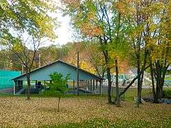 Park in Yatesville | |
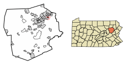 Location of Yatesville in Luzerne County, Pennsylvania. | |
 Yatesville Location of Yatesville in Luzerne County, Pennsylvania.  Yatesville Yatesville (the US) | |
| Coordinates: 41°18′11″N 75°46′54″W / 41.30306°N 75.78167°WCoordinates: 41°18′11″N 75°46′54″W / 41.30306°N 75.78167°W | |
| Country | United States |
| State | Pennsylvania |
| County | Luzerne |
| Region | Greater Pittston |
| Settled | 1809 |
| Incorporated | 1878 |
| Government | |
| • Type | Borough Council |
| Area[1] | |
| • Total | 0.61 sq mi (1.58 km2) |
| • Land | 0.61 sq mi (1.58 km2) |
| • Water | 0.00 sq mi (0.00 km2) |
| Population (2010) | |
| • Total | 607 |
| • Estimate (2016)[2] | 601 |
| • Density | 986.86/sq mi (381.25/km2) |
| Time zone | UTC-5 (Eastern (EST)) |
| • Summer (DST) | UTC-4 (EDT) |
| Area code(s) | 570 |
| FIPS code | 42-86952 |
Yatesville is a borough in the Greater Pittston area of Luzerne County, Pennsylvania. The population was 607 as of the 2010 census.[3]
History
In 1809, Joel Hale built the first frame house in what is now known as Yatesville. Mr. Hale owned most of the borough site. On May 20, 1878, Yatesville broke away from Jenkins Township and became a borough. The first election for the new community was held in June. The first burgess was T. T. Hale.[4][5]
Geography
Yatesville is located at 41°18′11″N 75°46′54″W / 41.30306°N 75.78167°W (41.302947, -75.781651).[6] According to the United States Census Bureau, the borough has a total area of 0.62 square miles (1.6 km2), all of it land. The borough is served by the Pittston Area School District.
Demographics
| Historical population | |||
|---|---|---|---|
| Census | Pop. | %± | |
| 1880 | 415 | — | |
| 1890 | 414 | −0.2% | |
| 1900 | 433 | 4.6% | |
| 1910 | 573 | 32.3% | |
| 1920 | 709 | 23.7% | |
| 1930 | 768 | 8.3% | |
| 1940 | 700 | −8.9% | |
| 1950 | 565 | −19.3% | |
| 1960 | 472 | −16.5% | |
| 1970 | 407 | −13.8% | |
| 1980 | 555 | 36.4% | |
| 1990 | 506 | −8.8% | |
| 2000 | 649 | 28.3% | |
| 2010 | 607 | −6.5% | |
| Est. 2016 | 601 | [2] | −1.0% |
| Sources:[7][8][9] | |||
As of the census[8] of 2000, there were 649 people, 233 households, and 188 families residing in the borough. The population density was 1,171.1 people per square mile (455.6/km2). There were 241 housing units at an average density of 434.9 per square mile (169.2/km2). The racial makeup of the borough was 99.69% White, 0.15% African American, and 0.15% from two or more races.
There were 233 households, out of which 31.8% had children under the age of 18 living with them, 63.5% were married couples living together, 12.9% had a female householder with no husband present, and 18.9% were non-families. 16.3% of all households were made up of individuals, and 7.3% had someone living alone who was 65 years of age or older. The average household size was 2.79 and the average family size was 3.11.
In the borough the population was spread out, with 22.8% under the age of 18, 6.0% from 18 to 24, 31.7% from 25 to 44, 25.4% from 45 to 64, and 14.0% who were 65 years of age or older. The median age was 38 years. For every 100 females there were 80.3 males. For every 100 females age 18 and over, there were 82.8 males.
The median income for a household in the borough was $46,429, and the median income for a family was $57,813. Males had a median income of $41,176 versus $23,333 for females. The per capita income for the borough was $24,551. About 1.5% of families and 2.9% of the population were below the poverty line, including 2.6% of those under age 18 and 5.6% of those age 65 or over.
References
- ↑ "2016 U.S. Gazetteer Files". United States Census Bureau. Retrieved Aug 14, 2017.
- 1 2 "Population and Housing Unit Estimates". Retrieved June 9, 2017.
- ↑ "Profile of General Population and Housing Characteristics: 2010 Demographic Profile Data (DP-1): Yatesville borough, Pennsylvania". U.S. Census Bureau, American Factfinder. Retrieved April 13, 2012.
- ↑ http://www.pagenweb.org/~luzerne/patk/yatesville.htm
- ↑ http://www.pagenweb.org/~luzerne/patk/patk.htm
- ↑ "US Gazetteer files: 2010, 2000, and 1990". United States Census Bureau. 2011-02-12. Retrieved 2011-04-23.
- ↑ "Census of Population and Housing". U.S. Census Bureau. Retrieved 11 December 2013.
- 1 2 "American FactFinder". United States Census Bureau. Retrieved 2008-01-31.
- ↑ "Incorporated Places and Minor Civil Divisions Datasets: Subcounty Resident Population Estimates: April 1, 2010 to July 1, 2012". Population Estimates. U.S. Census Bureau. Archived from the original on 17 June 2013. Retrieved 11 December 2013.
Municipalities and communities of Luzerne County, Pennsylvania, United States | ||
|---|---|---|
| Cities |  | |
| Boroughs |
| |
| Townships | ||
| CDPs | ||
| Unincorporated communities |
| |
| Footnotes | ‡This populated place also has portions in an adjacent county or counties | |