Browntown, Luzerne County, Pennsylvania
| Browntown, Pennsylvania | |
|---|---|
| Census-designated place | |
 Browntown, Pennsylvania Location within the state of Pennsylvania | |
| Coordinates: 41°18′46″N 75°47′8″W / 41.31278°N 75.78556°WCoordinates: 41°18′46″N 75°47′8″W / 41.31278°N 75.78556°W | |
| Country | United States |
| State | Pennsylvania |
| County | Luzerne |
| Township | Pittston |
| Area | |
| • Total | 0.5 sq mi (1.2 km2) |
| • Land | 0.5 sq mi (1.2 km2) |
| • Water | 0 sq mi (0 km2) |
| Population (2010) | |
| • Total | 1,418 |
| • Density | 3,100/sq mi (1,200/km2) |
| Time zone | UTC-5 (Eastern (EST)) |
| • Summer (DST) | UTC-4 (EDT) |
| ZIP code | 18640 |
| Area code(s) | 570 |
Browntown is a census-designated place (CDP) in Pittston Township, Luzerne County, Pennsylvania, United States, adjacent to Pittston City. The CDP population was 1,418 at the 2010 census.[1]
Geography
Browntown is located at 41°18′46″N 75°47′8″W / 41.31278°N 75.78556°W.[2]
According to the United States Census Bureau, the CDP has a total area of 0.46 square miles (1.2 km2), all of it land. Browntown is adjacent to the southeast border of Pittston City. The borough of Yatesville is to the south, and Hughestown is to the north. U.S. 11 passes through the northern part of the CDP.
References
- ↑ "Profile of General Population and Housing Characteristics: 2010 Demographic Profile Data (DP-1): Browntown CDP, Pennsylvania". U.S. Census Bureau, American Factfinder. Archived from the original on September 11, 2013. Retrieved April 19, 2012.
- ↑ "US Gazetteer files: 2010, 2000, and 1990". United States Census Bureau. 2011-02-12. Retrieved 2011-04-23.
Municipalities and communities of Luzerne County, Pennsylvania, United States | ||
|---|---|---|
| Cities | 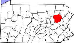 | |
| Boroughs |
| |
| Townships | ||
| CDPs | ||
| Unincorporated communities |
| |
| Footnotes | ‡This populated place also has portions in an adjacent county or counties | |
This article is issued from
Wikipedia.
The text is licensed under Creative Commons - Attribution - Sharealike.
Additional terms may apply for the media files.