Wanamie, Pennsylvania
| Wanamie | |
|---|---|
| Census-designated place | |
 Street in Wanamie | |
 Wanamie | |
| Coordinates: 41°10′24″N 76°02′08″W / 41.17333°N 76.03556°WCoordinates: 41°10′24″N 76°02′08″W / 41.17333°N 76.03556°W | |
| Country | United States |
| State | Pennsylvania |
| County | Luzerne |
| Area[1] | |
| • Total | 0.981 sq mi (2.54 km2) |
| • Land | 0.981 sq mi (2.54 km2) |
| • Water | 0 sq mi (0 km2) |
| Elevation | 676 ft (206 m) |
| Population (2010)[2] | |
| • Total | 612 |
| • Density | 620/sq mi (240/km2) |
| Time zone | UTC-5 (Eastern (EST)) |
| • Summer (DST) | UTC-4 (EDT) |
| Area code(s) | 570 |
| GNIS feature ID | 1190577[3] |
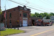
Fire station in Wanamie
Wanamie is an unincorporated community and census-designated place in Newport Township, Luzerne County, Pennsylvania. It is located in the southwest end of the Wyoming Valley and uses the Nanticoke zip code of 18634.[4] The South Branch Newport Creek forms the natural eastern boundary of Wanamie and drains it northeast via the Newport Creek into the Susquehanna River. The village is named after the Wanami tribe of the Lenni Lenape.[5] As of the 2010 census, its population was 612.[2]
References
- ↑ "US Gazetteer files: 2010, 2000, and 1990". United States Census Bureau. 2011-02-12. Retrieved 2011-04-23.
- 1 2 "American FactFinder". United States Census Bureau. Retrieved 2011-05-14.
- ↑ "Wanamie". Geographic Names Information System. United States Geological Survey.
- ↑ Nanticoke Pennsylvania ZIP Code Map
- ↑ Origins of Town Names in Northeast PA
Places adjacent to Wanamie, Pennsylvania | ||||||||||
|---|---|---|---|---|---|---|---|---|---|---|
| ||||||||||
Municipalities and communities of Luzerne County, Pennsylvania, United States | ||
|---|---|---|
| Cities | 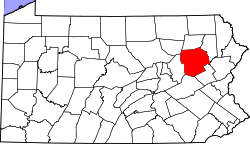 | |
| Boroughs |
| |
| Townships | ||
| CDPs | ||
| Unincorporated communities |
| |
| Footnotes | ‡This populated place also has portions in an adjacent county or counties | |
This article is issued from
Wikipedia.
The text is licensed under Creative Commons - Attribution - Sharealike.
Additional terms may apply for the media files.