Bear Creek Township, Luzerne County, Pennsylvania
| Bear Creek Township, Pennsylvania | |
|---|---|
| Township | |
.jpg) Bear Creek Falls | |
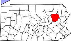
 Map of Luzerne County highlighting Bear Creek Township | |
 Map of Pennsylvania highlighting Luzerne County | |
| Country | United States |
| State | Pennsylvania |
| County | Luzerne |
| Government | |
| • Type | Board of supervisors |
| Area[1] | |
| • Total | 67.95 sq mi (176.00 km2) |
| • Land | 66.47 sq mi (172.17 km2) |
| • Water | 1.48 sq mi (3.83 km2) |
| Population (2010) | |
| • Total | 2,774 |
| • Estimate (2016)[2] | 2,761 |
| • Density | 41.53/sq mi (16.04/km2) |
| Time zone | UTC-5 (Eastern (EST)) |
| • Summer (DST) | UTC-4 (EDT) |
| FIPS code | 42-079-04592 |
| Website | Bear Creek Township |
Bear Creek Township is a township in Luzerne County, Pennsylvania, United States. The township has a total area of 67.8 square miles (176 km2), making it is the largest municipality (by total area) in Luzerne County. The population was 2,774 at the 2010 census.[3]
History
First settlers
Bear Creek was first settled in the late 18th century. The first log cabin was built in 1786 (about nine miles from Wilkes-Barre).[4] Bear Creek, with its abundance of trees, became the lumber king of Luzerne County. The first sawmill was built in 1800 by Oliver Helme. Many more sawmills were later constructed throughout the 19th century.[5]
Township
Bear Creek was later incorporated as a township; it was carved from territory taken from Wilkes-Barre, Pittston, Bucks, Plains, and Jenkins (in 1856). By 1890, the community had a population of 343.[6]
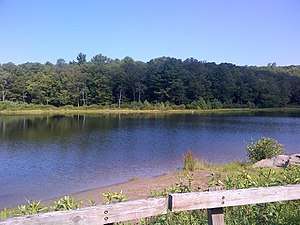
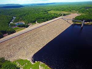
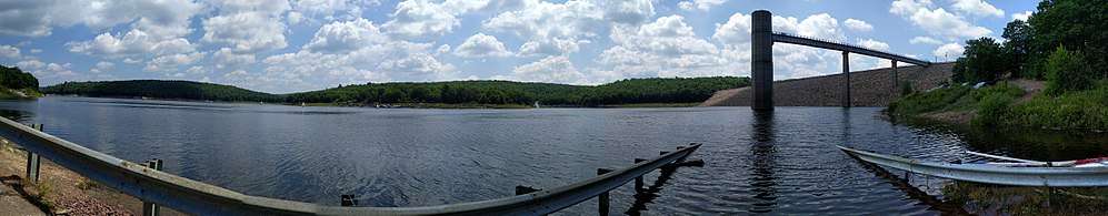
In 1961, the Bear Creek Dam was constructed in the southern portion of the township. The dam spans the Lehigh River at its confluence with the tributary Bear Creek. Although the dam was originally constructed for flood management, its reservoir has since become a popular recreational area for fishing, kayaking, and boating. In 1963, the dam was renamed after a United States Congressman (Francis E. Walter).[7][8][9]
In 1993, Bear Creek Village broke away from the township and became a borough. Today, the township is made up of several small villages, thick forests, lakes, and streams.
Air disaster
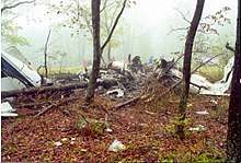
Bear Creek Township was the site of a plane crash on May 21, 2000; it crashed while attempting to land at the Wilkes-Barre/Scranton International Airport. As described by the BBC, the crash occurred in a "wooded area" of the township, near the intersection of Bear Creek Boulevard (PA-Route 115) and the Northeast Extension of the Pennsylvania Turnpike.
The accident killed the pilot as well as all 19 passengers. NTSB investigation ruled that the crash was probably due to low fuel. The incident spurred an FBI investigation and made news across the globe. Passenger safety in the aviation field became a major issue of the 2000 U.S. presidential election.[10]
21st century
The Bear Creek Wind Power Project began commercial operation in 2006. The wind farm consists of twelve Gamesa 2.0 MW wind turbines.[11]
Government
List of Bear Creek Township Supervisors:[12]
| Position | Name |
|---|---|
| Chairperson | Gary Zingaretti |
| Vice Chairperson | Joseph Masi |
| Supervisor | James Smith |
| Supervisor | Ruth A. Koval |
| Supervisor | Jeffrey Popple |
Geography
According to the United States Census Bureau, the township has a total area of 67.8 square miles (176 km2), of which 66.2 square miles (171 km2) is land and 1.6 square miles (4.1 km2), or 2.42%, is water. Bear Creek Township is the largest municipality (by total area) in Luzerne County. It is drained by both the Susquehanna and Lehigh rivers. The Francis E. Walter Dam and Reservoir is located in the southernmost section of the township (along the Lehigh River). The township's villages include Forest Park, Llewellyn Corners (also in Plains Township), and Pleasant View Summit.

Demographics
| Historical population | |||
|---|---|---|---|
| Census | Pop. | %± | |
| 2000 | 2,580 | — | |
| 2010 | 2,774 | 7.5% | |
| Est. 2016 | 2,761 | [2] | −0.5% |
| U.S. Decennial Census[13] | |||
As of the census[14] of 2000, there were 2,580 people, 997 households, and 754 families residing in the township. The population density was 39.0 people per square mile (15.0/km2). There were 1,216 housing units at an average density of 18.4/sq mi (7.1/km2). The racial makeup of the township was 98.88% White, 0.31% African American, 0.04% Native American, 0.31% Asian, 0.08% from other races, and 0.39% from two or more races. Hispanic or Latino of any race were 0.78% of the population.
There were 997 households, out of which 29.3% had children under the age of 18 living with them, 64.0% were married couples living together, 6.7% had a female householder with no husband present, and 24.3% were non-families. 20.5% of all households were made up of individuals, and 9.2% had someone living alone who was 65 years of age or older. The average household size was 2.55 and the average family size was 2.95.
In the township the population was spread out, with 21.7% under the age of 18, 6.0% from 18 to 24, 25.7% from 25 to 44, 29.2% from 45 to 64, and 17.4% who were 65 years of age or older. The median age was 43 years. For every 100 females, there were 104.4 males. For every 100 females age 18 and over, there were 101.1 males.
The median income for a household in the township was $43,900, and the median income for a family was $49,107. Males had a median income of $36,726 versus $26,053 for females. The per capita income for the township was $19,427. About 4.6% of families and 5.9% of the population were below the poverty line, including 5.1% of those under age 18 and 5.2% of those age 65 or over.
Gallery
References
- ↑ "2016 U.S. Gazetteer Files". United States Census Bureau. Retrieved Aug 14, 2017.
- 1 2 "Population and Housing Unit Estimates". Retrieved June 9, 2017.
- ↑ "Profile of General Population and Housing Characteristics: 2010 Demographic Profile Data (DP-1): Bear Creek township, Luzerne County, Pennsylvania". U.S. Census Bureau, American Factfinder. Archived from the original on September 11, 2013. Retrieved April 13, 2012.
- ↑ http://www.pagenweb.org/~luzerne/patk/bearcrk.htm
- ↑ http://www.pagenweb.org/~luzerne/patk/bearcrk.htm
- ↑ http://www.pagenweb.org/~luzerne/patk/bearcrk.htm
- ↑ "Francis E. Walter Dam Flow Management Plan". United States Army Corps of Engineers. Retrieved 26 June 2017.
- ↑ "USGS 01447780 Francis E. Walter Reservoir near White Haven, PA". USGS. Retrieved 26 June 2017.
- ↑ "Public Law 88-56". Act No. H.R. 5367 of 8 July 1963 (PDF).
- ↑ http://www.cnn.com/TRANSCRIPTS/0005/21/wv.10.html
- ↑ "Wind Farms in Pennsylvania". Pa Wind Working Group. Archived from the original on 30 January 2010. Retrieved 1 March 2010.
- ↑ http://bearcreektownship.org/index.php?minutes
- ↑ "Census of Population and Housing". Census.gov. Retrieved June 4, 2016.
- ↑ "American FactFinder". United States Census Bureau. Archived from the original on 2013-09-11. Retrieved 2008-01-31.
Municipalities and communities of Luzerne County, Pennsylvania, United States | ||
|---|---|---|
| Cities | | |
| Boroughs |
| |
| Townships | ||
| CDPs | ||
| Unincorporated communities |
| |
| Footnotes | ‡This populated place also has portions in an adjacent county or counties | |
Coordinates: 41°07′29″N 75°45′04″W / 41.12472°N 75.75111°W