Edwardsville, Pennsylvania
| Edwardsville, Pennsylvania | |
|---|---|
| Borough | |
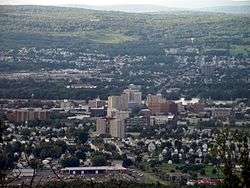 Edwardsville can be seen in the background (behind Wilkes-Barre City). | |
 Location of Edwardsville in Luzerne County, Pennsylvania. | |
 Edwardsville Location of Edwardsville in Luzerne County, Pennsylvania.  Edwardsville Edwardsville (the US) | |
| Coordinates: 41°15′58″N 75°54′30″W / 41.26611°N 75.90833°WCoordinates: 41°15′58″N 75°54′30″W / 41.26611°N 75.90833°W | |
| Country | United States |
| State | Pennsylvania |
| County | Luzerne |
| Settled | 1768[1] |
| Incorporated | 1884[1] |
| Government | |
| • Type | Borough Council |
| • Mayor | Bernard J. Dubaskas |
| Area[2] | |
| • Total | 1.19 sq mi (3.09 km2) |
| • Land | 1.16 sq mi (3.00 km2) |
| • Water | 0.04 sq mi (0.09 km2) |
| Population (2010) | |
| • Total | 4,816 |
| • Estimate (2016)[3] | 4,702 |
| • Density | 4,060.45/sq mi (1,567.11/km2) |
| Time zone | UTC-5 (Eastern (EST)) |
| • Summer (DST) | UTC-4 (EDT) |
| Zip code | 18704 |
| Area code(s) | 570 |
| FIPS code | 42-22672 |
| Website |
www |
Edwardsville is a borough in Luzerne County, Pennsylvania, United States. The population was 4,816 at the 2010 census.[4]
History
Edwardsville was first settled in 1768 by settlers from Connecticut. It was later incorporated as a borough in 1884.[1]
Geography

Edwardsville is located at 41°15′58″N 75°54′30″W / 41.26611°N 75.90833°W (41.266081, -75.908457).[5]
According to the United States Census Bureau, the borough has a total area of 1.2 square miles (3.1 km2), of which 1.2 square miles (3.0 km2) is land and 0.04 square miles (0.1 km2), or 2.95%, is water.[6] The Susquehanna River makes up the borough’s southern border.
Transportation
U.S. Route 11 is the only major highway running through Edwardsville.
Demographics
| Historical population | |||
|---|---|---|---|
| Census | Pop. | %± | |
| 1890 | 3,284 | — | |
| 1900 | 5,165 | 57.3% | |
| 1910 | 8,407 | 62.8% | |
| 1920 | 9,027 | 7.4% | |
| 1930 | 8,847 | −2.0% | |
| 1940 | 7,998 | −9.6% | |
| 1950 | 6,686 | −16.4% | |
| 1960 | 5,711 | −14.6% | |
| 1970 | 5,633 | −1.4% | |
| 1980 | 5,729 | 1.7% | |
| 1990 | 5,399 | −5.8% | |
| 2000 | 4,984 | −7.7% | |
| 2010 | 4,816 | −3.4% | |
| Est. 2016 | 4,702 | [3] | −2.4% |
| Sources:[7][8][9] | |||
As of the census[8] of 2000, there were 4,984 people, 2,345 households, and 1,280 families residing in the borough. The population density was 4,233.5 people per square mile (1,630.8/km2). There were 2,587 housing units at an average density of 2,197.4 per square mile (846.5/km2). The racial makeup of the borough was 95.43% White, 2.57% African American, 0.30% Native American, 0.30% Asian, 0.36% from other races, and 1.04% from two or more races. Hispanic or Latino of any race were 1.18% of the population.
There were 2,345 households, out of which 26.6% had children under the age of 18 living with them, 31.2% were married couples living together, 18.9% had a female householder with no husband present, and 45.4% were non-families. 41.1% of all households were made up of individuals, and 21.3% had someone living alone who was 65 years of age or older. The average household size was 2.09 and the average family size was 2.81.
In the borough the population was spread out, with 22.7% under the age of 18, 8.8% from 18 to 24, 26.7% from 25 to 44, 20.6% from 45 to 64, and 21.2% who were 65 years of age or older. The median age was 38 years. For every 100 females there were 78.8 males. For every 100 females age 18 and over, there were 73.0 males.
The median income for a household in the borough was $20,000, and the median income for a family was $26,908. Males had a median income of $25,733 versus $21,657 for females. The per capita income for the borough was $13,464. About 26.9% of families and 25.9% of the population were below the poverty line, including 34.6% of those under age 18 and 28.1% of those age 65 or over.
References
- 1 2 3 "Edwardsville Borough". Retrieved July 7, 2011.
- ↑ "2016 U.S. Gazetteer Files". United States Census Bureau. Retrieved Aug 14, 2017.
- 1 2 "Population and Housing Unit Estimates". Retrieved June 9, 2017.
- ↑ "Profile of General Population and Housing Characteristics: 2010 Demographic Profile Data (DP-1): Edwardsville borough, Pennsylvania". U.S. Census Bureau, American Factfinder. Archived from the original on September 11, 2013. Retrieved April 11, 2012.
- ↑ "US Gazetteer files: 2010, 2000, and 1990". United States Census Bureau. 2011-02-12. Retrieved 2011-04-23.
- ↑ "Geographic Identifiers: 2010 Demographic Profile Data (G001): Edwardsville borough, Pennsylvania". U.S. Census Bureau, American Factfinder. Archived from the original on September 11, 2013. Retrieved April 11, 2012.
- ↑ "Census of Population and Housing". U.S. Census Bureau. Archived from the original on 12 May 2015. Retrieved 11 December 2013.
- 1 2 "American FactFinder". United States Census Bureau. Archived from the original on 2013-09-11. Retrieved 2008-01-31.
- ↑ "Incorporated Places and Minor Civil Divisions Datasets: Subcounty Resident Population Estimates: April 1, 2010 to July 1, 2012". Population Estimates. U.S. Census Bureau. Archived from the original on 17 June 2013. Retrieved 11 December 2013.
External links
Municipalities and communities of Luzerne County, Pennsylvania, United States | ||
|---|---|---|
| Cities | 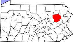 | |
| Boroughs |
| |
| Townships | ||
| CDPs | ||
| Unincorporated communities |
| |
| Footnotes | ‡This populated place also has portions in an adjacent county or counties | |