Hughestown, Pennsylvania
| Hughestown, Pennsylvania | |
|---|---|
| Borough | |
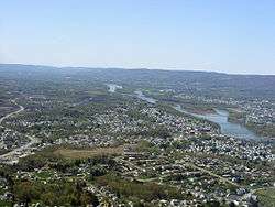 An image of Greater Pittston. Hughestown can be seen in the foreground. | |
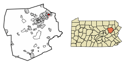 Location of Hughestown in Luzerne County, Pennsylvania. | |
 Hughestown Location of Hughestown in Luzerne County, Pennsylvania.  Hughestown Hughestown (the US) | |
| Coordinates: 41°19′38″N 75°46′31″W / 41.32722°N 75.77528°WCoordinates: 41°19′38″N 75°46′31″W / 41.32722°N 75.77528°W | |
| Country | United States |
| State | Pennsylvania |
| County | Luzerne |
| Region | Greater Pittston |
| Settled | 1836 |
| Incorporated | 1879 |
| Government | |
| • Type | Borough Council |
| • Mayor | Wayne D. Quick, Jr. |
| Area[1] | |
| • Total | 0.91 sq mi (2.36 km2) |
| • Land | 0.91 sq mi (2.36 km2) |
| • Water | 0.00 sq mi (0.00 km2) |
| Population (2010) | |
| • Total | 1,392 |
| • Estimate (2016)[2] | 1,373 |
| • Density | 1,505.48/sq mi (581.59/km2) |
| Time zone | UTC-5 (Eastern (EST)) |
| • Summer (DST) | UTC-4 (EDT) |
| Area code(s) | 570 |
| FIPS code | 42-36152 |
Hughestown is a borough in the Greater Pittston area of Luzerne County, Pennsylvania, United States. The population was 1,392 at the 2010 census.[3]
History
In 1934, the right arm of Hughestown resident Harry Tompkins was crushed by an Erie Railroad train. The resulting U.S. Supreme Court case, Erie Railroad Co. v. Tompkins, laid the foundation for a large part of modern American civil procedure.
Government
Hughestown's current mayor is Wayne D. Quick, Jr., and the President of Council is Robert Gable.
Geography

Hughestown is located at 41°19′38″N 75°46′31″W / 41.32722°N 75.77528°W (41.327180, -75.775336).[4]
According to the United States Census Bureau, the borough has a total area of 0.93 square miles (2.4 km2), all of it land. U.S. Route 11 runs through the southern portion of the borough. Hughestown is served by the Pittston Area School District. Robert Yaple Memorial Park is located in central Hughestown. Most of the homes and businesses are located in the western portion of the borough, while the eastern section consists of mostly forests and culm banks.
Demographics
| Historical population | |||
|---|---|---|---|
| Census | Pop. | %± | |
| 1880 | 1,192 | — | |
| 1890 | 1,454 | 22.0% | |
| 1900 | 1,548 | 6.5% | |
| 1910 | 2,024 | 30.7% | |
| 1920 | 2,244 | 10.9% | |
| 1930 | 2,252 | 0.4% | |
| 1940 | 2,340 | 3.9% | |
| 1950 | 1,888 | −19.3% | |
| 1960 | 1,615 | −14.5% | |
| 1970 | 1,407 | −12.9% | |
| 1980 | 1,783 | 26.7% | |
| 1990 | 1,734 | −2.7% | |
| 2000 | 1,541 | −11.1% | |
| 2010 | 1,392 | −9.7% | |
| Est. 2016 | 1,373 | [2] | −1.4% |
| Sources:[5][6][7] | |||
As of the census[6] of 2000, there were 1,541 people, 615 households, and 444 families residing in the borough. The population density was 1,734.6 people per square mile (668.5/km2). There were 659 housing units at an average density of 741.8 per square mile (285.9/km2). The racial makeup of the borough was 99.35% White, 0.13% African American, 0.06% Pacific Islander, 0.13% from other races, and 0.32% from two or more races. Hispanic or Latino of any race were 0.13% of the population.
There were 615 households, out of which 25.2% had children under the age of 18 living with them, 57.6% were married couples living together, 10.4% had a female householder with no husband present, and 27.8% were non-families. 24.6% of all households were made up of individuals, and 13.8% had someone living alone who was 65 years of age or older. The average household size was 2.50 and the average family size was 2.98.
In the borough the population was spread out, with 19.1% under the age of 18, 7.1% from 18 to 24, 27.1% from 25 to 44, 28.5% from 45 to 64, and 18.2% who were 65 years of age or older. The median age was 43 years. For every 100 females there were 97.3 males. For every 100 females age 18 and over, there were 88.2 males.
The median income for a household in the borough was $41,750, and the median income for a family was $50,938. Males had a median income of $33,611 versus $22,422 for females. The per capita income for the borough was $20,246. About 4.7% of families and 5.7% of the population were below the poverty line, including 4.2% of those under age 18 and 7.1% of those age 65 or over.
References
- ↑ "2016 U.S. Gazetteer Files". United States Census Bureau. Retrieved Aug 14, 2017.
- 1 2 "Population and Housing Unit Estimates". Retrieved June 9, 2017.
- ↑ "Profile of General Population and Housing Characteristics: 2010 Demographic Profile Data (DP-1): Hughestown borough, Pennsylvania". U.S. Census Bureau, American Factfinder. Retrieved April 12, 2012.
- ↑ "US Gazetteer files: 2010, 2000, and 1990". United States Census Bureau. 2011-02-12. Retrieved 2011-04-23.
- ↑ "Census of Population and Housing". U.S. Census Bureau. Archived from the original on 12 May 2015. Retrieved 11 December 2013.
- 1 2 "American FactFinder". United States Census Bureau. Retrieved 2008-01-31.
- ↑ "Incorporated Places and Minor Civil Divisions Datasets: Subcounty Resident Population Estimates: April 1, 2010 to July 1, 2012". Population Estimates. U.S. Census Bureau. Archived from the original on 17 June 2013. Retrieved 11 December 2013.
Municipalities and communities of Luzerne County, Pennsylvania, United States | ||
|---|---|---|
| Cities |  | |
| Boroughs |
| |
| Townships | ||
| CDPs | ||
| Unincorporated communities |
| |
| Footnotes | ‡This populated place also has portions in an adjacent county or counties | |