Borough of Woking
| Borough of Woking | |
|---|---|
| Non-metropolitan district | |
|
Motto(s): Fide et Diligentia (Latin: In faith and diligence) | |
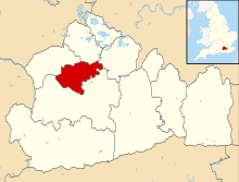 Woking shown within Surrey | |
| Sovereign state | United Kingdom |
| Constituent country | England |
| Region | South East England |
| Non-metropolitan county | Surrey |
| Status | Non-metropolitan district |
| Admin HQ | Woking |
| Incorporated | 1 April 1974 |
| Government | |
| • Type | Non-metropolitan district council |
| • Body | Woking Borough Council |
| • Leadership | Leader & Cabinet (Conservative) |
| • MPs | Jonathan Lord |
| Area | |
| • Total | 24.6 sq mi (63.6 km2) |
| Area rank | 259th (of 326) |
| Population (mid-2017 est.) | |
| • Total | 101,100 |
| • Rank | 237th (of 326) |
| • Density | 4,100/sq mi (1,600/km2) |
| • Ethnicity[1] |
91.3% White 6.3% S.Asian 1.7% Mixed 1.1% Black British 1.4% Chinese or Other |
| Time zone | UTC0 (GMT) |
| • Summer (DST) | UTC+1 (BST) |
| ONS code |
43UM (ONS) E07000217 (GSS) |
| OS grid reference | TQ0040358550 |
| Website |
www |
- See Woking for the town.
The Borough of Woking is a local government district with borough status in the west of Surrey, England. It is one of eleven districts in the county which has administrative status as to a different set of local government powers and responsibilities.
History
The borough's forebear was formed in 1895 — an urban district under the Local Government Act 1894. The precursor administrative areas were parishes run by vestries, which gradually ceded power after 1895:
This area was centred radically north of Woking Hundred; the other three parishes lay in Godley Hundred.[3]
The present borough was established in 1974 under the Local Government Act 1972, and is one of two districts in Surrey to retain the boundaries of a single former urban district, the other being Epsom and Ewell.
Geography
This is the only district of Surrey which does not border another county; the nearest is Berkshire, northwest of the relatively narrow shape of Surrey Heath, which is another district.
Woking Borough Council's head offices — named the Civic Offices — are in the centre of the town of Woking, just outside the town square.[4]
At the 2001 Census, the population of the borough was 88,125, over 70% of whom (62,796) lived in the town itself. The rest of the borough is divided into five villages with a modest semi-rural hinterland (which includes some of Surrey's 141 golf courses as at 2013):[5]
- Brookwood, population 1,442
- Byfleet, population 6,995
- Knaphill, population 10,062
- Mayford, population 1,776
- West Byfleet, population 5,054[6]
Byfleet constitutes a civil parish in the borough (no longer covering West Byfleet); a third-tier of local government does not serve the remaining bulk of the borough.
Elections
Elections to the council are held in three out of every four years, with one third of the 36 seats on the council being elected at each election. The elections are normally battled out between the Conservative Party and the Liberal Democrats. From the 1998 election to 2007 no party had a majority on the council, but in the 2007 election the Conservative party won a majority.[7] Since then until 2009, the Conservatives had 19 seats on the council compared to 17 for the Liberal Democrats.[8] Following the resignation of councillor Peter Ankers from the Conservatives to sit as an independent in 2009[9] the Conservatives continued in administration as the largest Party with 18 seats but with no overall control. At the 2011 election 20 Conservative and 16 Liberal Democrats were elected giving the Conservatives an overall majority once again.[10] In the 2012 elections the Conservatives took a further seat from the Liberal Democrats, giving them 21 seats to the Liberal Democrats 15.
Following the 2018 local elections, the Liberal Democrats gained one councillor at the expense of the conservatives. This gave the Conservatives a majority of 2 on the Council.
See also
References
- ↑ Office for National Statistics: Neighbourhood Statistics: Woking
- ↑ http://www.visionofbritain.org.uk/unit/10107477 University of Portsmouth and Others A Vision of Britain - historic statistics
- ↑ 'The hundred of Woking: Introduction and map', in A History of the County of Surrey: Volume 3, ed. H E Malden (London, 1911), p. 339. British History Online http://www.british-history.ac.uk/vch/surrey/vol3/p339
- ↑ Surrey Council Archived 2011-09-26 at the Wayback Machine.
- ↑ "Does gorgeous Surrey need golf course No 142?" Max Davidson, The Daily Telegraph, 8 Jun 2013
- ↑ Surrey County council census data Archived October 25, 2007, at the Wayback Machine.
- ↑ "Woking". BBC News Online. Retrieved 2010-01-24.
- ↑ "Woking". BBC News Online. 2008-04-19. Retrieved 2010-01-24.
- ↑ Woodger, Beth (16 July 2009). "Tory councillor quits party in council debt protest". getsurrey. Retrieved 12 February 2011.
- ↑ "Woking". BBC News Online. 19 April 2009. Retrieved 13 February 2011.
External links
| Towns, villages and hamlets | | ||||
|---|---|---|---|---|---|
| Parks | |||||
| Places of worship | |||||
| Education | |||||
| Transport | |||||
| Buildings and structures | |||||
| Sport |
| ||||
Coordinates: 51°19′0.08″N 0°33′32.86″W / 51.3166889°N 0.5591278°W