Warton Crag
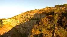

Warton Crag is a limestone hill in north west Lancashire, England. It lies to the north west of Warton village, in City of Lancaster district. At 163 metres (535 ft) it is the highest point in the Arnside and Silverdale Area of Outstanding Natural Beauty,[1] and is listed as a "HuMP" or "Hundred Metre Prominence", its parent being Hutton Roof Crags.[2] Two areas are Local Nature Reserves, called Warton Crag[3][4] and Warton Crag Quarry.[5][6] Different sections are owned by Lancashire County Council, the Wildlife Trust for Lancashire, Manchester and North Merseyside, Lancaster City Council and the Royal Society for the Protection of Birds.[7]
Two caves on the west side of the hill called Dog Holes and Badger Hole show signs of early human occupation, with excavations finding a range of artefacts.[8][9][10]
The summit of the hill was the site of a small multivallate hillfort during the Iron Age period. The approximately 3.2-hectare (7.9-acre) enclosure was defended by rock scarps and steep slopes to the south and west with triple stone ramparts forming an arc on the other sides.[11][12][13]
Many plants are found on the crag, including horseshoe vetch near its northern limit, spindle tree and many ferns.[14] The site is rich in butterflies, including the rare pearl bordered fritillary and high brown fritillary.[14] Much of the hill is listed as a Site of Special Scientific Interest, being considered the best example of limestone grassland in Lancashire, with areas of Limestone pavement.[15]
The former quarry on the west of the crag is a regular breeding site for peregrine falcons and is protected by a Falcon Watch team of volunteers.[16]
The crag is used by rock-climbers,[17] and a fell race on the crag takes place annually as part of Warton Children's Sports Day.[18]
See also
References
- ↑ Arnside and Silverdale AONB. A Guide to Warton Crag Nature Reserves. p. 3.
- ↑ Jackson, Mark (2009). "Carlisle to the Ribble and the Aire". More Relative Hills of Britain (PDF). p. 136.
- ↑ "Warton Crag". Local Nature Reserves. Natural England. Retrieved 26 July 2013.
- ↑ "Map of Warton Crag". Local Nature Reserves. Natural England. Retrieved 26 July 2013.
- ↑ "Warton Crag Quarry". Local Nature Reserves. Natural England. Retrieved 26 July 2013.
- ↑ "Map of Warton Crag Quarry". Local Nature Reserves. Natural England. Retrieved 26 July 2013.
- ↑ Arnside and Silverdale AONB. A Guide to Warton Crag Nature Reserves. pp. 10–11.
- ↑ Historic England. "Dog Holes Cave (41539)". PastScape. Retrieved 10 March 2018.
- ↑ Historic England. "Badger Hole (41540)". PastScape. Retrieved 10 March 2018.
- ↑ John Wilfrid Jackson (1913). Third report on the exploration at Dog Holes, Warton Crag, Lancs. R. Gill. Retrieved 10 March 2018.
- ↑ Historic England. "Warton Crag small multivallate hillfort (1007633)". National Heritage List for England. Retrieved 25 February 2018.
- ↑ Historic England. "Warton Crag hilltop enclosure (41541)". PastScape. Retrieved 10 March 2018.
- ↑ Farrer, William; Brownbill, John, eds. (1908). The Victoria History of the County of Lancaster Vol 2. Victoria County History - Constable & Co. pp. 508–511. OCLC 59375181. Retrieved 10 March 2018.
- 1 2 "Warton Crag". Wildlife Trust for Lancashire, Manchester and North Merseyside. Retrieved 10 February 2017.
- ↑ "Warton Crag SSSI" (PDF). Natural England. Retrieved 10 March 2018.
- ↑ "New male Peregrine takes up residence: Warton Crag has a new male Peregrine". Arnside and Silverdale AONB. 21 December 2010. Retrieved 28 November 2012.
- ↑ "Warton Crag". LakesBloc: Lake District Bouldering. Retrieved 28 November 2012.
- ↑ "Warton Crag: Race Details". Fellrunner.org.uk. Retrieved 28 November 2012.
External links
- AONB website
- pdf of the AONB's 20-page guide
- Chapman, Gerg. "Warton Crag Bouldering" (PDF). LakesBloc. p. 8. Retrieved 28 November 2012.
- Map of Warton Crag Local Nature Reserve