Wall Street (IRT Broadway–Seventh Avenue Line)
Wall Street | |||||||||||||
|---|---|---|---|---|---|---|---|---|---|---|---|---|---|
|
| |||||||||||||
 148th Street-bound 3 train leaves the station | |||||||||||||
| Station statistics | |||||||||||||
| Address |
Wall Street & William Street New York, NY 10005 | ||||||||||||
| Borough | Manhattan | ||||||||||||
| Locale | Financial District | ||||||||||||
| Coordinates | 40°42′23″N 74°00′34″W / 40.706311°N 74.009528°WCoordinates: 40°42′23″N 74°00′34″W / 40.706311°N 74.009528°W | ||||||||||||
| Division | A (IRT) | ||||||||||||
| Line | IRT Broadway–Seventh Avenue Line | ||||||||||||
| Services |
2 3 | ||||||||||||
| Structure | Underground | ||||||||||||
| Platforms | 1 island platform | ||||||||||||
| Tracks | 2 | ||||||||||||
| Other information | |||||||||||||
| Opened | July 1, 1918 | ||||||||||||
| Station code | 335[1] | ||||||||||||
| Wireless service |
| ||||||||||||
| Traffic | |||||||||||||
| Passengers (2017) |
6,935,020[3] | ||||||||||||
| Rank | 62 out of 425 | ||||||||||||
| Station succession | |||||||||||||
| Next north |
Fulton Street: 2 | ||||||||||||
| Next south |
Clark Street: 2 | ||||||||||||
| |||||||||||||
| |||||||||||||
| |||||||||||||


Wall Street is a station on the IRT Broadway–Seventh Avenue Line of the New York City Subway, located at the intersection of Wall Street and William Street in the Financial District of Manhattan. It is served by the 2 train at all times and the 3 train at all times except late nights.
History

The Wall Street station was built on the portion of the IRT Broadway–Seventh Avenue Line built as part of the Dual Contracts, which is the section south of Times Square–42nd Street. The line first opened as a shuttle to 34th Street–Penn Station on June 3, 1917,[4][5] and then south to South Ferry on July 1, 1918. On this same date, the Wall Street station opened, with service to the station running as a shuttle between Chambers Street and Wall Street, on the line's Brooklyn Branch.[6] On August 1, 1918, the new "H" system was implemented on August 1, 1918, joining the two halves of the Broadway–Seventh Avenue Line and sending all West Side trains south from Times Square.[7] As a result, shuttle service to this station was replaced by through service.[8] This station was the line's terminus until April 15, 1919, when the Clark Street Tunnel opened, allowing service to run to Brooklyn.[9]
During the 1964–1965 fiscal year, the platforms at Wall Street, along with those at four other stations on the Broadway–Seventh Avenue Line, were lengthened to 525 feet to accommodate a ten-car train of 51-foot IRT cars.[10]
In 1995, as a result of service reductions, the MTA was considering permanently closing one of the two Wall Street stations, as well as two other stations citywide, due to their proximity to each other. Either the IRT Broadway–Seventh Avenue Line or the IRT Lexington Avenue Line station would have been closed.[11]
Station layout
| G | Street Level | Exit/ Entrance |
| M | Mezzanine | Fare control, station agent |
| P Platform level |
Northbound | ← ← |
| Island platform, doors will open on the left | ||
| Southbound | → → | |
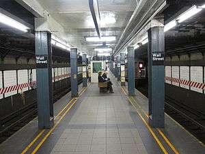
This underground station is the southernmost in Manhattan on the Brooklyn Branch of the Broadway–Seventh Avenue Line.[12] South of here, the line travels under the East River via the Clark Street Tunnel to Brooklyn Heights. The single island platform is between the two tracks, and is very narrow compared to other stations in system. It has blue I-beam columns and dark blue floors tiles. The walls by the tracks have small "W" tablets on a mosaic trim except at the north end, where they have "WALL ST" written in black letters on white tablets over a green trim line. This is where the platform was extended in 1964–1965.[10]
There is a narrow full length mezzanine above the platform that has mosaics pointing to and connecting all four station entrances.
Exits
This station has four entrances/exits:
- The first exit is at the northern end of the station. It has a customer assistance booth with a bank of turnstiles and long passageway to a set of doors, where a short staircase goes up to the front entrance of One Chase Manhattan Plaza. Though signs at this entrance/exit say it leads to Cedar and William Streets, which are right outside the building, it does not go to the actual streets and the building entrance has no signs informing people that there is a subway entrance inside. This entrance is only open on weekdays.[13]
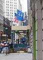
- The second exit, also open weekdays only, contains a bank of turnstiles and passageway to a spiral staircase that leads to Pine Street outside 60 Wall Street. The passageway has an artwork called Subway Wall by Harry Roseman made in 1990 and installed after a 1993 station renovation. This exit also has a set of doors to two escalators and a double-wide staircase that go up to the public atrium lobby of 60 Wall Street. This entrance has two red globes and overhead signs, giving the impression of an outdoor station entrance built in the lobby.[13]
- The third exit was the first to open to the station and is staffed full-time. It has a bank of turnstiles and staircases to both northern corners of William and Wall Streets. The entrance at the northeast corner is made of ornate medal and has a sign reading "Interborough Rapid Transit Co-to All Trains."
- The last exit is at the south end of the station, which leads to the same intersection as the third exit but is in a separate fare control area. A single double-wide staircase from the platform leads to two HEET turnstiles and two regular turnstiles. Staircases lead to the both southern corners of William and Wall Streets. This exit, though open at all times, is unstaffed as there is no token booth.[13]
Image gallery
 Entrance/Exit #3 from Wall Street
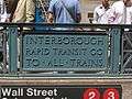 Old IRT sign at an entrance
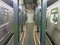 The platform viewed from the extremely narrow north end
 Mezzanine above the platforms
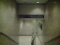 Entrance #1, from One Chase Manhattan Plaza
 Part-time entrance #2 is from the lobby of 60 Wall Street
References
- ↑ "Station Developers' Information". Metropolitan Transportation Authority. Retrieved June 13, 2017.
- ↑ "NYC Subway Wireless – Active Stations". Transit Wireless Wifi. Retrieved May 18, 2016.
- ↑ "Facts and Figures: Annual Subway Ridership 2012–2017". Metropolitan Transportation Authority. July 12, 2018. Retrieved July 12, 2018.
- ↑ "Three New Links of the Dual Subway System Opened, Including a Shuttle Service from Times Square to Thirty-Fourth Street — Service on the Jerome Avenue Branch From 149th Street North to About 225th Street Began Yesterday Afternoon — The Event Celebrated by Bronx Citizens and Property Owners — The Seventh Avenue Connection Opened This Morning" (PDF). The New York Times. June 3, 1917. p. 1. Retrieved November 6, 2016.
- ↑ "Annual report. 1916-1917". HathiTrust. Interborough Rapid Transit Company. December 12, 2013. p. 22. Retrieved September 5, 2016.
- ↑ "Open New Subway to Regular Traffic — First Train on Seventh Avenue Line Carries Mayor and Other Officials — To Serve Lower West Side — Whitney Predicts an Awakening of the District — New Extensions of Elevated Railroad Service" (PDF). The New York Times. July 2, 1918. p. 11. Retrieved November 6, 2016.
- ↑ "Open New Subway Lines to Traffic; Called a Triumph — Great H System Put in Operation Marks an Era in Railroad Construction — No Hitch in the Plans — But Public Gropes Blindly to Find the Way in Maze of New Stations — Thousands Go Astray — Leaders in City's Life Hail Accomplishment of Great Task at Meeting at the Astor" (PDF). The New York Times. August 2, 1918. p. 1. Retrieved November 6, 2016.
- ↑ Whitney, Travis H. (March 10, 1918). "The Seventh and Lexington Avenue Subways Will Revive Dormant Sections — Change in Operation That Will Transform Original Four-Tracked Subway Into Two Four-Tracked Systems and Double Present Capacity of the Interborough" (PDF). The New York Times. p. 12. Retrieved August 26, 2016.
- ↑ "New Subway Service Between Brooklyn and Manhattan Boroughs". The New York Times. April 13, 1919. Retrieved September 5, 2009.
- 1 2 Annual Report 1964–1965. New York City Transit Authority. 1965.
- ↑ Perez-Pena, Richard (1995-02-25). "BOARD VOTES CUTS FOR CITY TRANSIT". The New York Times. Retrieved 2018-05-16.
- ↑ "ALL ROADS NOW LEAD TO TIMES SQUARE; Old Tube the Base of the New. The Fifth Spoke in the Hub. How the "H" Is Formed. Difficulties of the Work. Much Depends on the Public" (PDF). Retrieved July 4, 2016.
- 1 2 3 "MTA Neighborhood Maps: Lower Manhattan" (PDF). mta.info. Metropolitan Transportation Authority. 2014. Retrieved August 3, 2016.
External links
| Wikimedia Commons has media related to Wall Street (IRT Broadway – Seventh Avenue Line). |
- nycsubway.org – IRT West Side Line: Wall Street
- nycsubway.org – Subway Wall Artwork by Harry Roseman (1990)
- Station Reporter – 2 Train
- Station Reporter – 3 Train
- TheSubwayNut Pictures – Wall Street (2,3)
- MTA's Arts For Transit – Wall Street (IRT Broadway–Seventh Avenue Line)
- Wall Street and William Street entrance from Google Maps Street View
- One Chase Manhattan Plaza entrance from Google Maps Street View
- Pine Street entrance from Google Maps Street View
- 60 Wall Street entrance from Google Maps Street View
- Platform from Google Maps Street View