Værøy
| Værøy kommune | |||
|---|---|---|---|
| Municipality | |||
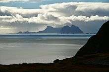
 View of the village of Værøy | |||
| |||
 Værøy within Nordland | |||
| Coordinates: 67°40′23″N 12°40′09″E / 67.67306°N 12.66917°ECoordinates: 67°40′23″N 12°40′09″E / 67.67306°N 12.66917°E | |||
| Country | Norway | ||
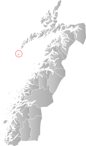
| County | Nordland | ||
| District | Lofoten | ||
| Established | 1838 | ||
| Administrative centre | Sørland | ||
| Government | |||
| • Mayor (2015) | Dagfinn Arntsen (KrF) | ||
| Area | |||
| • Total | 18.64 km2 (7.20 sq mi) | ||
| • Land | 18.60 km2 (7.18 sq mi) | ||
| • Water | 0.04 km2 (0.02 sq mi) | ||
| Area rank | #417 in Norway | ||
| Population (2017) | |||
| • Total | 744 | ||
| • Rank | #411 in Norway | ||
| • Density | 40.0/km2 (104/sq mi) | ||
| • Change (10 years) | -0.5% | ||
| Demonym(s) | Værøyværing[1] | ||
| Time zone | UTC+01:00 (CET) | ||
| • Summer (DST) | UTC+02:00 (CEST) | ||
| ISO 3166 code | NO-1857 | ||
| Official language form | Bokmål | ||
| Website |
varoy | ||
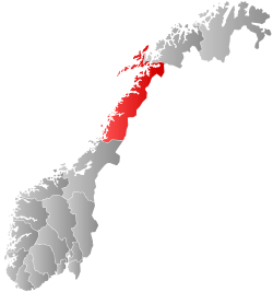
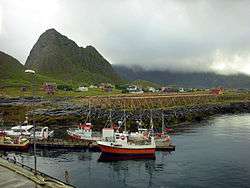
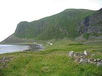
Værøy is an island and municipality in Nordland county, Norway. It is part of the traditional district of Lofoten. The administrative centre of the municipality is the village of Sørland. The other village in Værøy is Nordland. Most of the residents live in the Sørland area surrounding the main harbor. The old Værøy Lighthouse sits at the end of that harbor.
The 19-square-kilometre (7.3 sq mi) municipality is the 417th largest by area out of the 422 municipalities in Norway. Værøy is the 411th most populous municipality in Norway with a population of only 415. The municipality's population density is 40 inhabitants per square kilometre (100/sq mi) and its population has decreased by 0.5% over the last decade.[2]
General information
The municipality of Værøy was established on 1 January 1838 (see formannskapsdistrikt). On 1 July 1928, the southern district of Værøy (population: 731) was separated to become the new municipality of Røst.[3]
Name
The Old Norse form of the name was Veðrøy. The first element is veðr which means "weather" (here referring to harsh weather and the exposed and unsheltered position of the island). The last element is øy which means "island". Historically, the name has been spelled Værø.[4]
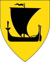
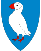
Coat-of-arms
The coat-of-arms is from modern times; they were granted on 10 July 1988. The arms show a puffin on a blue background. Puffins nest in large numbers in the area and used to be of great importance for the village, both for meat and down.[5]
Churches
The Church of Norway has one parish (sokn) within the municipality of Værøy. It is part of the Bodø domprosti (arch-deanery) in the Diocese of Sør-Hålogaland.
| Parish (Sokn) | Church Name | Location of the Church | Year Built |
|---|---|---|---|
| Værøy | Værøy Church | Sørland | 1939 |
| Old Værøy Church | Nordland | 1799 |
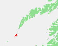
Geography
The island municipality is made up of many islands, the two largest islands being Værøya and Mosken. It is located at the end of the Lofoten archipelago. The Norwegian Sea lies to the northwest and the Vestfjorden lies to the southeast. The Moskenstraumen maelstrom lies to the north between Værøy and Moskenesøya.
Climate
The weather in Værøy can be very changeable. Sunshine, rain, wind, and mist may interchange rapidly. The winter climate is mild and the temperature seldom drops below 0 °C (32 °F). This makes conditions for stockfish exceptionally good.
Røst and Værøy are famous with meteorologists, as they are the most northern locations in the world where there is no meteorological winter because the average temperature generally stays above freezing all year. The winter temperatures in southern Lofoten represent the highest temperature anomaly in the world relative to latitude due to the Gulf Stream from the Caribbean Sea. However, the winter weather is rather windy and damp, so it does not feel so mild.[6]
The polar night occurs from December 13- 29 and the midnight sun occurs from May 28- July 15.
Government
All municipalities in Norway, including Værøy, are responsible for primary education (through 10th grade), outpatient health services, senior citizen services, unemployment and other social services, zoning, economic development, and municipal roads. The municipality is governed by a municipal council of elected representatives, which in turn elect a mayor.
Municipal council
The municipal council (Kommunestyre) of Værøy is made up of 13 representatives that are elected to four year terms. Currently, the party breakdown is as follows:[7]
| Party Name | Name in Norwegian | Number of representatives | |
|---|---|---|---|
| Labour Party | Arbeiderpartiet | 2 | |
| Christian Democratic Party | Kristelig Folkeparti | 3 | |
| Local Lists | Lokale lister | 8 | |
| Total number of members: | 13 | ||
Transportation
Helicopter transport is available from Bodø at the Værøy Heliport in Sørland. There was airplane service at Værøy Airport, but it was discontinued after the Værøy accident in 1990 in which five people lost their lives. The airport was determined to be in a bad position, due to the location next to a mountain and the frequent presence of strong and unpredictable winds, which made takeoffs and landings dangerous.[8] Ferry service is also available from Bodø, Moskenes, and Røst.
Tourist attractions
- Sportfishing for cod, coalfish, and halibut is practiced here.
- Turstien is a floodlit track which was opened in 1999. The surface is suitable for bikers, prams, and wheelchairs.
- Breivika is situated on the road between Sørland and Nordland, and is the location of the Skarsursanden beach. From the main road there is a signposted path going up Breivikdalen.
- Heia has views of the island. It can be reached via a step path called Bjørka, or by following the tarred road up Rømdalen. About halfway there is an old eagle trapping site.
- Eagle trapping is a tradition peculiar to the Værøy islanders. They caught eagles with their bare hands. Ancient sites can still be seen, at Rømdalen, for instance.
- Gjerdeheia forms a vast and completely flat plateau on top. It can be reached from Breiviksdalen by turning left at the end of the valley or following the path going up Rømdalen and turning right before passing Hornet.
- Nordlandsnupen is Værøy's highest mountain. One must reach it by walking up Breiviksdalen and turning right at the end of the valley.
- Mollbakken in Nordland consists of smoothly ground round stones. Here, many burial sites from the Viking Age have been found.
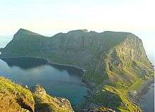
- Old Værøy Church in Nordland is the oldest church in Lofoten, built around 1740. The altarpiece dates back to about 1714 and features alabaster figures made in England in 1430.
- Nordlandshagen - the Garden of Nordland - is a popular area for the outdoor life. The midnight sun can be seen here from May 30 to July 13.
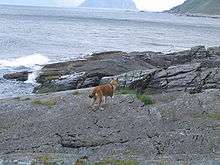
- Mostad is located in the south. The mountainside more or less hangs right over the old, derelict village of Mostad. This is where the puffin dog originated. Often people will walk from Nordlandshagen.
- Norwegian Lundehund or Puffin dog is one of Norway's seven breeds of dogs, and the rarest one. It has an extra toe, is small, and very agile. Puffin dogs were used solely for the puffin hunt and because the hunt was of such great importance to the islanders, this race of dogs managed to survive in Værøy.
- Sanden is a beach with a 400-metre (1,300 ft) tall wall of rock towers over the spot, making it incredibly warm on fine summer days. Access is only by boat.
In literature
- The island of "Vurrgh" in Edgar Allan Poe's story A Descent into the Maelström (1841) is Værøy.[9]
References
- ↑ "Navn på steder og personer: Innbyggjarnamn" (in Norwegian). Språkrådet. Retrieved 2015-12-01.
- ↑ Statistisk sentralbyrå (2017). "Table: 06913: Population 1 January and population changes during the calendar year (M)" (in Norwegian). Retrieved 2017-09-23.
- ↑ Jukvam, Dag (1999). "Historisk oversikt over endringer i kommune- og fylkesinndelingen" (PDF) (in Norwegian). Statistisk sentralbyrå.
- ↑ Rygh, Oluf (1905). Norske gaardnavne: Nordlands amt (in Norwegian) (16 ed.). Kristiania, Norge: W. C. Fabritius & sønners bogtrikkeri. p. 351.
- ↑ Norske Kommunevåpen (1990). "Nye kommunevåbener i Norden". Retrieved 2008-11-30.
- ↑ "Lofoten Temperature Anomalies". Atlas Obscura. Retrieved 2017-09-23.
- ↑ "Table: 04813: Members of the local councils, by party/electoral list at the Municipal Council election (M)" (in Norwegian). Statistics Norway. 2015.
- ↑ "Accident description". Aviation-Safety.net. Retrieved 2008-11-30.
- ↑ Fisher, Benjamin F., ed. (2004). The Essential Tales and Poems of Edgar Allan Poe. Spark Educational Publishing. p. 231. ISBN 1-59308-064-6.
External links
| Wikimedia Commons has media related to Værøy. |

- Municipal fact sheet from Statistics Norway (in Norwegian)
| |||||||||||||||||
| |||||||||||||||||