Union Parish, Louisiana
| Union Parish, Louisiana | |
|---|---|
 Union Parish Courthouse in Farmerville | |
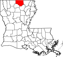 Location in the U.S. state of Louisiana | |
 Louisiana's location in the U.S. | |
| Founded | March 13, 1839 |
| Named for | Union of American states |
| Seat | Farmerville |
| Largest town | Farmerville |
| Area | |
| • Total | 905 sq mi (2,344 km2) |
| • Land | 877 sq mi (2,271 km2) |
| • Water | 28 sq mi (73 km2), 3.06% |
| Population (est.) | |
| • (2015) | 22,477 |
| • Density | 26/sq mi (10/km2) |
| Congressional district | 4th |
| Time zone | Central: UTC−6/−5 |
Union Parish (French: Paroisse de l'Union) is a parish located in the U.S. state of Louisiana. As of the 2010 census, the population was 22,721.[1] The parish seat is Farmerville.[2] The parish was created on March 13, 1839, from a section of Ouachita Parish. Its boundaries have changed four times since then (in 1845, 1846, 1867, and 1873, respectively).[3]
Union Parish is part of the Monroe, LA Metropolitan Statistical Area.
Union Parish/Union County monument
In 1931, a monument was erected at the Union Parish border with Union County, Arkansas, through the private efforts of former Arkansas Governor George Washington Donaghey (1856–1937).[4] He was born in Union Parish and grew up in the border area before moving with his family as a teenager to Conway, Arkansas. As governor of Arkansas, Donaghey oversaw the construction of the state capitol building in Little Rock and implemented founding of the state health unit and its agricultural colleges.
Long having felt a kinship to both states, after his gubernatorial tenure Donaghey commissioned a park on the border land and a monument. The monument is known for its intricate carvings and Art Deco style. It includes references to different modes of transportation in 1831 and 1931 and mentions Louisiana Governor Huey P. Long, Jr., whose educational program Donaghey admired. The land was not registered with the state parks offices in either state, timber companies cut trees thereabouts, and the monument was forgotten. In 1975, State Representative Louise B. Johnson gained passage of a law to refurbish the monument. A completed restoration was unveiled in 2009.[4]
Geography
According to the U.S. Census Bureau, the parish has a total area of 905 square miles (2,340 km2), of which 877 square miles (2,270 km2) is land and 28 square miles (73 km2) (3.1%) is water.[5]
Geographically, north central Louisiana closely resembles Lincoln Parish, to which Union Parish is deeply tied culturally, politically, and educationally. The Piney Hills country is very different from the flat, hardwood delta lands of northeastern Louisiana.
Major highways
Adjacent parishes and counties
- Union County, Arkansas (northwest)
- Ashley County, Arkansas (northeast)
- Morehouse Parish (east)
- Ouachita Parish (southeast)
- Lincoln Parish (southwest)
- Claiborne Parish (west)
National protected areas
Demographics
| Historical population | |||
|---|---|---|---|
| Census | Pop. | %± | |
| 1840 | 1,838 | — | |
| 1850 | 8,203 | 346.3% | |
| 1860 | 10,389 | 26.6% | |
| 1870 | 11,685 | 12.5% | |
| 1880 | 13,526 | 15.8% | |
| 1890 | 17,304 | 27.9% | |
| 1900 | 18,520 | 7.0% | |
| 1910 | 20,451 | 10.4% | |
| 1920 | 19,621 | −4.1% | |
| 1930 | 20,731 | 5.7% | |
| 1940 | 20,943 | 1.0% | |
| 1950 | 19,141 | −8.6% | |
| 1960 | 17,624 | −7.9% | |
| 1970 | 18,447 | 4.7% | |
| 1980 | 21,167 | 14.7% | |
| 1990 | 20,690 | −2.3% | |
| 2000 | 22,803 | 10.2% | |
| 2010 | 22,721 | −0.4% | |
| Est. 2016 | 22,487 | [6] | −1.0% |
| U.S. Decennial Census[7] 1790-1960[8] 1900-1990[9] 1990-2000[10] 2010-2013[1] | |||
As of the census[11] of 2000, there were 22,803 people, 8,857 households, and 6,412 families residing in the parish. The population density was 26 people per square mile (10/km²). There were 10,873 housing units at an average density of 12 per square mile (5/km²). The racial makeup of the parish was 69.79% White, 27.95% Black or African American, 0.19% Native American, 0.26% Asian, 0.05% Pacific Islander, 1.26% from other races, and 0.50% from two or more races. 2.02% of the population were Hispanic or Latino of any race.
There were 8,857 households out of which 31.30% had children under the age of 18 living with them, 55.30% were married couples living together, 13.70% had a female householder with no husband present, and 27.60% were non-families. 24.90% of all households were made up of individuals and 11.00% had someone living alone who was 65 years of age or older. The average household size was 2.52 and the average family size was 3.01.
In the parish the population was spread out with 25.70% under the age of 18, 9.10% from 18 to 24, 26.50% from 25 to 44, 23.80% from 45 to 64, and 14.90% who were 65 years of age or older. The median age was 37 years. For every 100 females there were 94.50 males. For every 100 females age 18 and over, there were 90.90 males.
The median income for a household in the parish was $29,061, and median income of a family was $36,035. Males had a median income of $30,494 versus $21,070 for females. The per capita income for the parish was $14,819. About 14.30% of families and 18.60% of the population were below the poverty line, including 25.60% of those under age 18 and 17.70% of those age 65 or over.
Politics
Located in far northern Louisiana next to the Arkansas state line, Union Parish is heavily Republican in most competitive elections, particularly at the presidential level. In 2012, Mitt Romney received 7,561 votes (70.2 percent) of the parish total to 3,075 (28.6 percent) for U.S. President Barack Obama.[12]
| Year | Republican | Democratic | Third parties |
|---|---|---|---|
| 2016 | 73.2% 7,972 | 24.7% 2,691 | 2.1% 231 |
| 2012 | 70.2% 7,561 | 28.6% 3,075 | 1.2% 130 |
| 2008 | 70.1% 7,619 | 28.6% 3,103 | 1.3% 146 |
| 2004 | 69.6% 7,457 | 28.8% 3,089 | 1.6% 172 |
| 2000 | 61.8% 5,772 | 34.3% 3,205 | 3.9% 366 |
| 1996 | 46.3% 4,418 | 44.6% 4,260 | 9.1% 865 |
| 1992 | 44.0% 4,434 | 39.8% 4,005 | 16.2% 1,630 |
| 1988 | 63.0% 5,900 | 34.3% 3,210 | 2.8% 259 |
| 1984 | 67.7% 6,585 | 30.0% 2,916 | 2.3% 222 |
| 1980 | 55.8% 5,130 | 41.8% 3,841 | 2.5% 227 |
| 1976 | 52.4% 4,139 | 45.5% 3,600 | 2.1% 166 |
| 1972 | 70.2% 4,322 | 23.8% 1,465 | 6.0% 370 |
| 1968 | 16.5% 1,113 | 19.8% 1,336 | 63.7% 4,297 |
| 1964 | 79.7% 4,534 | 20.3% 1,155 | |
| 1960 | 49.6% 2,017 | 25.5% 1,034 | 24.9% 1,012 |
| 1956 | 40.5% 1,384 | 25.7% 878 | 33.8% 1,156 |
| 1952 | 48.0% 1,894 | 52.0% 2,055 | |
| 1948 | 9.1% 259 | 25.4% 724 | 65.6% 1,873 |
| 1944 | 31.3% 803 | 68.7% 1,765 | |
| 1940 | 11.6% 371 | 88.5% 2,842 | |
| 1936 | 13.3% 272 | 86.7% 1,778 | |
| 1932 | 2.5% 58 | 97.5% 2,285 | |
| 1928 | 28.0% 422 | 71.9% 1,085 | 0.1% 2 |
| 1924 | 0.8% 7 | 99.1% 875 | 0.1% 1 |
| 1920 | 7.4% 98 | 92.6% 1,221 | |
| 1916 | 2.0% 22 | 98.0% 1,106 | 0.1% 1 |
| 1912 | 1.4% 11 | 87.7% 696 | 11.0% 87 |
Education
Residents are assigned to Union Parish Public Schools.
Communities
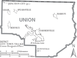
Towns
- Bernice
- Farmerville (parish seat)
- Marion
Villages
Unincorporated communities
- Alabama Landing
- Point
- Shiloh
Notable people
Two Louisiana governors came from the Shiloh Community in Union Parish:
- William Wright Heard, 1900–1904
- Ruffin Pleasant, 1916-1920
Two Arkansas governors were natives of Union Parish:
- George Washington Donaghey, governor of Arkansas from 1909 to 1913
- Tom Jefferson Terral, governor of Arkansas from 1925 to 1927
Other Union Parish residents have included:
- Lonnie O. Aulds (1925-1984), state representative from 1968 to 1972 from Shreveport, real estate developer, born in Union Parish[14]
- George Washington Bolton (1841-1931), state representative from 1888 to 1896 from Alexandria; Speaker of the House from 1892 to 1896; businessman, banker, school board member, Southern Baptist layman in Alexandria, lived and educated in Union Parish in his father's private school prior to the American Civil War[15]
- Grady A. Dugas - physician in Marion who invented a system of wheelchair locks[16]
- Harvey Fields, state senator from 1916 to 1920, member of the Louisiana Public Service Commission from 1927 to 1936, briefly a law partner of Huey Pierce Long, Jr., in Shreveport[17] His son, T. T. Fields, served in the Louisiana House of Representatives from 1952 to 1964 and 1968 to 1972.
- Jay McCallum - Chief Judge of the Louisiana 3rd Judicial District Court (elected in 2003); ran un-opposed in 2014 for a term ending in 2020; state representative for Lincoln and Union parishes, 1992-2003; formerly practiced law in Farmerville after graduating from Louisiana State University School of Law in 1985[18]
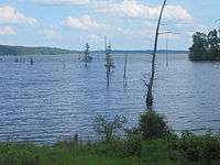
- B. R. Patton (1920-1999), state senator for Lincoln and Union parishes, 1956 to 1964; worked on the establishment of Lake D'Arbonne at Farmerville
- Fred Preaus (1912-1987), businessman from Farmerville, ran unsuccessfully in the 1956 Democratic gubernatorial primary election; lost to Earl Kemp Long
- Robert Roberts, Jr., Union Parish native born 1872, mayor of Farmerville c. 1900, mayor of Minden 1905-1906, state representative for Webster Parish 1908-1914, and state district judge 1920 to 1925[19]
- James Peyton Smith (1925-2006), born in the Conway Community in Union Parish; state representative from Union and Morehouse parishes from 1964 to 1972; namesake of Louisiana Highway 33 bridge over Lake D'Arbonne in Farmerville[20]
- Lee Emmett Thomas, was born in Marion in Union Parish and educated as a child in the Shiloh Community at the former Concord Institute. He was mayor of Shreveport (1922–1930) and Speaker of the Louisiana House of Representative (1912–1916). Thomas also served by appointment in both the Heard and Pleasant administrations.[21]
See also
Sources
Many facts concerning events in early Union Parish history come from the conveyance, probate, and lawsuit records on file in the Union Parish courthouse, as well as records of the United States Land Offices available in the National Archives. Other sources include:
1) Williams, E. Russ, Jr., Spanish Poste d’Ouachita: The Ouachita Valley in Colonial Louisiana 1783–1804, and Early American Statehood, 1804–1820, Williams Genealogical Publications, Monroe, LA, 1995.
2) Williams, E. Russ, Jr., Encyclopedia of Individuals and Founding Families of the Ouachita Valley of Louisiana From 1785 to 1850: Organized into Family Groups with Miscellaneous Materials on Historical Events, Places, and Other Important Topics, Part Oe A – K, Williams Genealogical and Historical Publications, Monroe, LA, 1996.
3) Williams, E. Russ, Jr., Encyclopedia of Individuals and Founding Families of the Ouachita Valley of Louisiana From 1785 to 1850: Organized into Family Groups with Miscellaneous Materials on Historical Events, Places, and Other Important Topics, Part Two L – O, Williams Genealogical and Historical Publications, Monroe, LA, 1997.
4) Williams, Max Harrison, Union Parish (Louisiana) Historical Records: Police Jury Minutes, 1839–1846, D’Arbonne Research and Publishing Co., Farmerville, LA, 1993.
References
- 1 2 "State & County QuickFacts". United States Census Bureau. Retrieved August 18, 2013.
- ↑ "Find a County". National Association of Counties. Archived from the original on May 31, 2011. Retrieved 2011-06-07.
- ↑ "Archived copy". Archived from the original on March 29, 2015. Retrieved January 22, 2015.
- 1 2 "Matthew Hamil, "Monument Forgotten by Time"". Monroe News Star, August 31, 2009. Archived from the original on September 3, 2009. Retrieved August 31, 2009.
- ↑ "2010 Census Gazetteer Files". United States Census Bureau. August 22, 2012. Archived from the original on September 28, 2013. Retrieved September 2, 2014.
- ↑ "Population and Housing Unit Estimates". Retrieved June 9, 2017.
- ↑ "U.S. Decennial Census". United States Census Bureau. Archived from the original on May 12, 2015. Retrieved September 2, 2014.
- ↑ "Historical Census Browser". University of Virginia Library. Retrieved September 2, 2014.
- ↑ "Population of Counties by Decennial Census: 1900 to 1990". United States Census Bureau. Retrieved September 2, 2014.
- ↑ "Census 2000 PHC-T-4. Ranking Tables for Counties: 1990 and 2000" (PDF). United States Census Bureau. Retrieved September 2, 2014.
- ↑ "American FactFinder". United States Census Bureau. Archived from the original on September 11, 2013. Retrieved 2008-01-31.
- ↑ "Union Parish presidential election returns, November 6, 2012". staticresults.sos.la.gov. Retrieved November 11, 2012.
- ↑ Leip, David. "Dave Leip's Atlas of U.S. Presidential Elections". uselectionatlas.org. Retrieved 2018-03-07.
- ↑ "Membership of the Louisiana House of Representatives, 1812-2012" (PDF). legis.la.gov. Archived from the original (PDF) on October 4, 2013. Retrieved July 8, 2013.
- ↑ "Bolton, George Washington". Louisiana Historical Association: A Dictionary of Louisiana Biography. Archived from the original on April 13, 2014. Retrieved April 9, 2014.
- ↑ "Dr. Grady A. Dugas". The Monroe News-Star. March 26, 2007. Archived from the original on February 18, 2015. Retrieved February 18, 2015.
- ↑ "Harvey Goodwyn Fields, Sr". findagrave.com. Retrieved October 24, 2014.
- ↑ "Louisiana: McCallum, Jay Bowen", Who's Who in American Politics, 2003-2004, 19th ed., Vol. 1 (Alabama-Montana) (Marquis Who's Who: New Providence, New Jersey, 2003), p. 787
- ↑ Henry E. Chambers, "Robert Roberts, Jr.", A History of Louisiana, Vol. 2 (Chicago and New York City, American Historical Society, Inc., 1925), pp. 21-22
- ↑ "Greg Hilburn, State honors the late Rep. Smith with bridge renaming, September 12, 2013". Monroe News-Star. Archived from the original on May 14, 2014. Retrieved September 13, 2013.
- ↑ "Thomas, Lee Emmett". Louisiana Historical Association, A Directory of Louisiana Biography (lahistory.org). Archived from the original on September 23, 2010. Retrieved December 29, 2010.
Places adjacent to Union Parish, Louisiana | ||||||||||
|---|---|---|---|---|---|---|---|---|---|---|
| ||||||||||
Municipalities and communities of Union Parish, Louisiana, United States | ||
|---|---|---|
| Towns | | |
| Villages | ||
| Unincorporated communities | ||
| Footnotes | ‡This populated place also has portions in an adjacent parish or parishes | |