Union station (TTC)
Union | ||||||||||||||||||||
|---|---|---|---|---|---|---|---|---|---|---|---|---|---|---|---|---|---|---|---|---|
.jpg) Union station eastbound platform | ||||||||||||||||||||
| Location |
55 Front Street West, Toronto, Ontario Canada | |||||||||||||||||||
| Coordinates | 43°38′44″N 79°22′50″W / 43.64556°N 79.38056°WCoordinates: 43°38′44″N 79°22′50″W / 43.64556°N 79.38056°W | |||||||||||||||||||
| Platforms | Side platforms | |||||||||||||||||||
| Connections |
| |||||||||||||||||||
| Construction | ||||||||||||||||||||
| Structure type | Underground | |||||||||||||||||||
| Disabled access | Yes | |||||||||||||||||||
| History | ||||||||||||||||||||
| Opened | March 30, 1954 | |||||||||||||||||||
| Rebuilt | 2011–2015 | |||||||||||||||||||
| Traffic | ||||||||||||||||||||
| Passengers (2016[1]) | 118,450 | |||||||||||||||||||
| Services | ||||||||||||||||||||
| ||||||||||||||||||||
Union is a subway station on Line 1 Yonge–University of the rapid transit system in Toronto, Ontario, Canada. It opened in 1954 as one of twelve original stations on the first phase of the Yonge line, the first rapid transit line in Canada. It was the southern terminus of the line until the opening of the University line in 1963, and is today the inflection point of the U-shaped line. Along with Spadina station, it is one of two stations open overnight.[2]
Union station is located on Front Street between the Yonge Street and University Avenue sections of the line. It is named for and directly connects to the railway station and regional bus terminal of the same name, serving all GO Transit train lines and train-bus services as well as Via Rail intercity routes (including Amtrak's Maple Leaf service to New York City). It connects to the Union Pearson Express (UPX), a dedicated rail link to Toronto Pearson International Airport. It is the only subway station with a direct connection to Via services.
Based on Toronto's street grid, Union is the southernmost subway station and the closest to Lake Ontario; however, using standard compass directions, Kipling and Islington stations are further south. It serves approximately 100,000 people a day, ranking it as the fourth-busiest station in the system, after Bloor–Yonge, St. George, and Sheppard–Yonge, and the busiest served by only one line. Adjacent to the subway station is an underground terminal loop for two streetcar routes, the 509 Harbourfront and 510 Spadina.
In 2007, Union subway station became the first location on the TTC where Presto cards could be used, as part of a trial. Wi-Fi service has been available at this station since 2014.[3]
Entrances
North side entrances:
- Street-level stairs on north side of Front Street.
- Underground connection from Royal Bank Plaza
- Underground connection from Brookfield Place
South side entrances:
- 2 street-level staircases on south side of Front Street.
- Outdoor connections via the "moat" to the Union railway station
History
The station opened as the southern terminus of the original Yonge subway line on March 30, 1954.
On February 28, 1963, Union became a through station with the opening of the University section of the Yonge–University line.
On June 22, 1990, Union became the terminus of route 604 Harbourfront LRT, now part of the 509 Harbourfront and 510 Spadina streetcar routes. A new underground streetcar platform was built south of the subway tracks, connected to the station concourse by a 30-metre pedestrian tunnel and a flight of stairs.[4]
Elevators were installed in 1996, making Union one of the first wheelchair-accessible subway stations in Toronto.[5] An elevator was added to the streetcar platforms, even though streetcars were not accessible themselves. By the time accessible streetcars began serving the station in 2014, the elevator had been replaced as a part of the station expansion.[4]
On August 18, 2014, a second subway platform was opened to serve Yonge line trains, leaving the existing platform to serve only University line trains.[6]
Flexity Outlook streetcars started to serve Union from route 510 Spadina on October 12, 2014,[7] and from route 509 Harbourfront on March 29, 2015.[8] As a result, passengers are now required to have Proof-of-payment (POP) to depart Union by streetcar.[9]
Station expansion
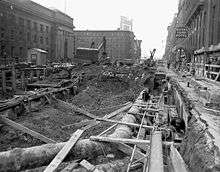
In 2003, planning began on a station expansion to address overcrowding in the station. Despite being one of the busiest stations in the system, the station had only one narrow island platform serving both the University and Yonge lines, and a small concourse area.
The resulting plan was to build a new subway platform on the south side of the tracks to serve the Yonge line, leaving the existing island platform to serve only the University line. This new platform would feature a level connection to the streetcar platform. The project also included significantly expanding the concourse level and replacing all finishes.
Preparatory work began in 2006, and construction began in February 2011.[6] The new second platform opened on August 18, 2014.[4][10]
Station decor
When the station opened in 1954, the wall coverings were glossy yellow Vitrolite tiles with red lettering and trim, and the station name on the walls was in the TTC's unique Toronto Subway Font.
During renovations in the 1980s, the yellow vitrolite tiles were replaced with brown ceramic tiles and vinyl siding and the station font was changed to Univers.
The 2011–2015 station expansion replaced these tiles and panels with white tiles and black trim, and the station name was returned to its original Toronto Subway typeface.[4]
As part of the second platform project, a glass wall was built to block off the southern side of the old platform, since it now only serves the University line. It features the art piece "Zones of Immersion" by Stuart Reid, a professor at the OCAD University[11][12] The work comprises 166 large glass panels, each measuring more than one by two metres, extending 170-metre (560 ft) along the length of the platform. Mostly transparent, it is visible from both the Yonge and University platforms. Each panel contains images or words, many based on sketches that Reid drew while riding the subway.

_-_Artwork_-_Zones_of_Immersion_-_2_women_on_a_train.JPG)
Subway infrastructure in the vicinity
_-_signal_on_platform.JPG)
The station lies on an east–west axis axis along Front Street. It is one of three stations on Line 1 with an east–west orientation, the others being St. George and Downsview Park. Leaving the station eastbound, the Yonge leg of the line runs briefly under the street and turns 90 degrees north to run under Yonge Street; leaving westbound, the University leg also runs under Front Street, and shortly after turns 90 degrees north to run under University Avenue.
This station is one of only three that have a slightly curved platform (the other two being St. Clair and Museum stations). The station is also noted as being one of only three where a signal is publicly accessible (the others being Davisville and Islington stations). The signal is located on the east (trailing) end of the University line platform. It is an interlocking signal that protects the crossover to the northbound Yonge Line and is only occasionally used to reverse Yonge Line trains at Union.[4]
Streetcar loop
Union Station Loop was opened for streetcar service in 1990. It is located at the north end of a tunnel under Bay Street from the underground Queens Quay station at the street named Queens Quay. The tunnel is over 500 metres long. Union Station Loop is currently inadequate for the volume of customers it currently handles because of its single track and its curved, narrow platform. The present loop will not be able to handle the peak demand of 3700 people per hour projected for 2041.[13]
A 2010 Environmental Assessment (EA) for the East Bayfront LRT (a proposed streetcar line) approved rebuilding the existing streetcar loop plus the construction of a connection from the streetcar tunnel to the East Bayfront LRT on Queens Quay East. The EA design would rebuild the loop to have four platforms, each with a bypass track, so that a streetcar could bypass other streetcars loading or unloading. Design work was 30% complete, but the project was never funded. Expansion of the loop's capacity is needed in order to support an East Bayfront LRT.[13]
As of 2017, two options are being considered to increase capacity:[13]
- Rebuilding the loop as per the 2010 EA, or
- Replace streetcar service at Union station with a funicular in the tunnel to Queens Quay station, where passengers transfer to streetcar service.
Nearby landmarks
Nearby landmarks include the Union Station railway station, the Royal York Hotel, Scotiabank Arena, Rogers Centre, the Metro Toronto Convention Centre, the CN Tower, Royal Bank Plaza, Brookfield Place, the Hockey Hall of Fame, and the Sony Centre for the Performing Arts.
Surface connections
A direct connection between the subway and streetcars within the fare-paid zone is provided for these routes:
| Route | Name | Additional Information |
|---|---|---|
| 509 | Harbourfront | Westbound to Exhibition Loop |
| 510 | Spadina | Northbound to Spadina station via Harbourfront |
| 310 | Spadina Blue Night | Northbound to Spadina station via Harbourfront |
Access to these routes is also available while the subway is not running, as the station is open overnight.
A transfer is required to connect between the subway or streetcars and these bus routes at curbside stops:
| Route | Name | Additional Information |
|---|---|---|
| 6 | Bay | Southbound to Queens Quay and Sherbourne Street |
| 6A | Northbound to Dupont Street | |
| 6B | Northbound to Bloor Street West (Davenport Road/Yonge Street) | |
| 72B | Pape | Northbound to Pape station via Queens Quay and Commissioners Street |
| 97B | Yonge | Northbound to York Mills station and southbound to Queens Quay |
| 121A | Fort York-Esplanade | Eastbound to Distillery and Westbound to Exhibition (Princes' Gates Loop) |
| 121D | Eastbound to Cherry Beach Loop via Distillery and Westbound to Ontario Place (Seasonal service) | |
| 320 | Yonge Blue Night | Northbound to Steeles Avenue East and southbound to Queens Quay |
References
- ↑ "Subway ridership, 2016" (PDF). Toronto Transit Commission. Retrieved July 3, 2018.
This table shows the typical number of customer-trips made on each subway on an average weekday and the typical number of customers travelling to and from each station platform on an average weekday.
- ↑ "Route 510 - The Spadina Streetcar - Transit Toronto - Content". transit.toronto.on.ca. Retrieved 2018-05-29.
- ↑ "Wi-fi Now Available At". TCONNECT. Archived from the original on February 20, 2015. Retrieved January 8, 2015.
Each of the 65 underground stations will have wireless and Wi-Fi service by 2017.
- 1 2 3 4 5 James Bow. "Union". Transit Toronto. Retrieved May 15, 2015.
- ↑ "Milestones". About the TTC. Toronto Transit Commission. Retrieved December 7, 2014.
1996: Downsview Station, Bloor-Yonge Station, and Union Station become the first accessible subway stations.
- 1 2 Robert Mackenzie. "TTC opening second subway platform at Union Station, August 18". Toronto Transit Commission. Retrieved May 17, 2015.
- ↑ Munro, Steve (October 12, 2014). "Streetcars Return to Queens Quay". Steve Munro. Retrieved June 16, 2015.
- ↑ Steve Munro (February 6, 2015). "TTC Service Changes Effective March 29, 2015". Steve Munro. Retrieved May 17, 2015.
- ↑ "Proof-of-Payment (POP)". Fares & Passes. Toronto Transit Commission. Archived from the original on April 4, 2015. Retrieved May 17, 2015.
- ↑ http://transit.toronto.on.ca/archives/weblog/2014/08/15-ttc_openin.shtml
- ↑ Nick Westoll (August 17, 2014). "TTC opens Union Subway Station second platform". Retrieved August 18, 2014.
The TTC will also be installing a 500-foot glass art wall to block off the southern side of the University line platform. Stuart Reid won an international public art competition for his piece, "Zones of Immersion," in 2012.
- ↑ Christopher Hume (March 31, 2015). "Union Station artwork an exercise in artistic transparency". The Toronto Star. Retrieved May 13, 2015.
- 1 2 3 "Waterfront Transit Update" (PDF). Toronto Transit Commission. November 13, 2017. Retrieved November 13, 2017.
External links

- Union Station at the Toronto Transit Commission
- Stuart Reid – "Zones of Immersion" union station toronto,[sic] anticipated completion 2014
- History of Union station at Transit Toronto