Davisville station
Davisville | |||||||||||
|---|---|---|---|---|---|---|---|---|---|---|---|
 | |||||||||||
| Location |
1900 Yonge Street Toronto, Ontario Canada | ||||||||||
| Coordinates | 43°41′52″N 79°23′50″W / 43.69778°N 79.39722°WCoordinates: 43°41′52″N 79°23′50″W / 43.69778°N 79.39722°W | ||||||||||
| Platforms |
Centre platform Side platform | ||||||||||
| Tracks | 3 | ||||||||||
| Connections |
| ||||||||||
| Construction | |||||||||||
| Structure type | Above ground | ||||||||||
| Disabled access | Yes | ||||||||||
| History | |||||||||||
| Opened | 30 March 1954 | ||||||||||
| Traffic | |||||||||||
| Passengers (2016[1]) | 24,300 | ||||||||||
| Services | |||||||||||
| |||||||||||
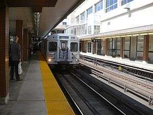
Davisville is a subway station on Line 1 Yonge–University in Toronto, Ontario, Canada. It is located at 1900 Yonge Street at Chaplin Crescent/Davisville Avenue. The station opened in 1954 as part of the original Toronto subway. In 2002, this station became accessible with elevators. The station is on three levels: the entrances are located on street level, the concourse and collector are on the second level, and the subway platforms are on the lower level.
Entrances
There are four entrances that connect the station to two buildings in the area:
- three accessible entrances from the TTC head office
- an automatic entrance at 1910 Yonge Street, near Chaplin Crescent, which leads directly to the northbound subway platform (accessible only by Presto Card)
Subway infrastructure in the vicinity
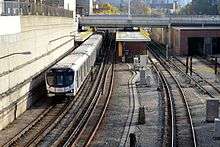
The station is constructed above ground, but below street level, with separate canopies over each platform. It is adjacent to the Davisville Subway Yard, which is visible from the trains and platforms. The station has a unique semi-active third platform, on the yard side - actually referred to as the Davisville Buildup - which can be used by trains entering or leaving the yard on service or as an alternate route if one of the running lines is blocked.
The line continues in open cut in both directions: north as far as the Berwick Portal, immediately before Eglinton station; and south as far as the Muir Portal, roughly halfway to St. Clair station, from which it continues in tunnel.
Davisville is one of only three stations in the subway system where a track signal is publicly accessible (with the other being Islington station). The signal is located at the southern end of the southbound platform, below the pedestrian overpass to the bus terminal.
Nearby landmarks
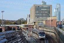
Nearby landmarks include the Mount Pleasant Cemetery, the Upper Canada College campus, and the TTC's main administrative office building, the Wm. C. McBrien Building. The station's bus platforms are under the western half of the building at street level, and the open-air northbound subway platform abuts against the building's west wall.
The former Canadian National Railways Belt Line Railway railway corridor crosses over the subway tracks south of the station. It has been converted into a pedestrian and biking trail, called the Beltline Trail.
Surface connections
TTC routes serving the station include:
| Route | Name | Additional Information |
|---|---|---|
| 11A | Bayview | Northbound to Steeles Avenue East via Sunnybrook Hospital |
| 11C | Northbound to Sunnybrook Hospital | |
| 14 | Glencairn | Westbound to Caledonia Road |
| 28 | Bayview South | Southbound to Evergreen Brick Works |
| 97A | Yonge | Northbound to York Mills station via Yonge Boulevard |
| 97B | Northbound to York Mills station and Southbound to Queens Quay (Rush hour service) | |
| 97F | Northbound to Steeles Avenue |
References
- ↑ "Subway ridership, 2016" (PDF). Toronto Transit Commission. Retrieved July 3, 2018.
This table shows the typical number of customer-trips made on each subway on an average weekday and the typical number of customers travelling to and from each station platform on an average weekday.
External links
![]()