Ulukışla
| Ulukışla | |
|---|---|
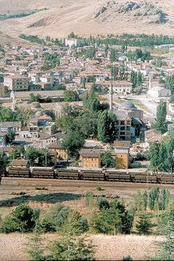 General view of Ulukışla | |
 Ulukışla | |
| Coordinates: 37°32′48″N 34°29′04″E / 37.54667°N 34.48444°ECoordinates: 37°32′48″N 34°29′04″E / 37.54667°N 34.48444°E | |
| Country |
|
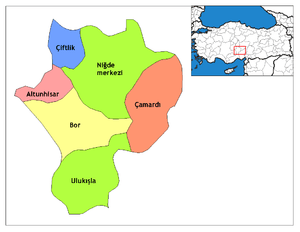
| Province | Niğde |
| Government | |
| • Mayor | Ali Ugurlu (AKP) |
| • Kaymakam | Ozan Gazel |
| Area[1] | |
| • District | 1,512.69 km2 (584.05 sq mi) |
| Population (2012)[2] | |
| • Urban | 5,009 |
| • District | 20,897 |
| • District density | 14/km2 (36/sq mi) |
| Website | www.ulukisla.bel.tr/ |
Ulukışla is a town and district of Niğde Province in the Central Anatolia region of Turkey. It covers an area of 1,502 km², and the altitude is 1,427 m. Population is 22,728 of which 5,594 live in the town of Ulukışla.[3]
The town of Ulukışla lies in a valley between the Medetsiz and Bolkar ranges of the Taurus Mountains, throughout history an important crossing from the Mediterranean to the plains of Konya and other parts of central Anatolia. This is a mountainous district and minerals including gold, silver, lead, coal and limestone have been mined here over the centuries. The climate is dry and the vegetation typical of the dry steppes of central Anatolia, summers are hot and dry, winters are cold and it snows. Wheat is grown in the valley.
History
There are burial mounds höyük and other signs of occupation going back to the Hittites and even earlier. The area was later occupied by Phrygians, and Romans. the tomb of Faustina the Younger, wife of Emperor Marcus Aurelius was found in the village of Toraman, and the baths of Çiftehan claim among their patrons Cleopatra (in the time when she was living in Tarsus). The Byzantines had armies based here, and then Ulukışla remained an important town in the time of the Ottoman Empire.
Ulukışla today
Ulukışla is a small market town in a rural area. The railway and the E5 highway from Adana and the south-east of Turkey to Ankara and the west pass through here. There is a technical college of Niğde University here.
Places of interest
- The therapeutic mineral baths of Çiftehan.
- The 17th century caravanserai of Öküz Mehmet Paşa, a classical example of the roadside havens built for journeys on the Silk Road to Iran and points east. The inspiration for Han Duvarları a famous poem by Faruk Nafiz Çamlıbel.
- Medetsiz mountain and other peaks in the Bolkar range are popular with climbers, and there are also caves and canyons for adventure sports.
References
Falling Rain Genomics, Inc. "Geographical information on Ulukışla, Turkey". Retrieved 2008-03-14.
- ↑ "Area of regions (including lakes), km²". Regional Statistics Database. Turkish Statistical Institute. 2002. Retrieved 2013-03-05.
- ↑ "Population of province/district centers and towns/villages by districts - 2012". Address Based Population Registration System (ABPRS) Database. Turkish Statistical Institute. Retrieved 2013-02-27.
- ↑ Statistical Institute Archived 2011-08-24 at the Wayback Machine.
External links
- District governor's official website (in Turkish)
- District municipality's official website (in Turkish)
- A web portal of Niğde (in Turkish)
- Yesilbor.com (in Turkish)
| Authority control |
|---|