Udawalawe Dam
| Uda Walawe Dam | |
|---|---|
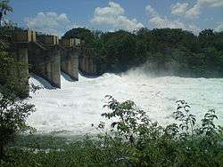 The dam with all four spillways open. | |
| Country | Sri Lanka |
| Location | Udawalawe |
| Coordinates | 06°26′02″N 80°51′15″E / 6.43389°N 80.85417°ECoordinates: 06°26′02″N 80°51′15″E / 6.43389°N 80.85417°E |
| Purpose | Irrigation, Power |
| Status | Operational |
| Dam and spillways | |
| Type of dam | Embankment dam |
| Impounds | Walawe River |
| Length | 3.9 km (2.4 mi) |
| Spillways | 4 |
| Spillway type | Tainter gate |
| Reservoir | |
| Creates | Udawalawe Reservoir |
| Total capacity | 267MCM |
| Maximum length | 8.6 km (5.3 mi) |
| Maximum width | 7 km (4.3 mi) |
| Udawalawe Power Station | |
| Coordinates | 06°25′55″N 80°51′02″E / 6.43194°N 80.85056°E |
| Operator(s) | CEB |
| Commission date | April 1969 |
| Type | Conventional |
| Turbines | 3 × 2 MW |
| Installed capacity | 6 MW |
The Udawalawe Dam is a large irrigation dam in Udawalawe, in the Southern Province of Sri Lanka. The dam consists of an embankment section and a gravity section, combining the total dam length to approximately 3.9 km (2.4 mi). The dam is also used for hydroelectric power generation, powering three 2 MW units, commissioned in April 1969.[1]
The water level of the reservoir is controlled by the five tainter gate spillways located at the eastern end of the dam, with two additional spillways located more towards to the centre of the dam. The reservoir measures approximately 8.6 km (5.3 mi) in length, with a maximum perpendicular width of 7 km (4.3 mi).
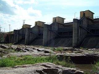
The four tainter gate spillways.

Road over the larger embankment dam.
See also
| Wikimedia Commons has media related to Udawalawe Dam. |
References
- ↑ "CEB Generation Network". Ceylon Electricity Board. Archived from the original on 16 January 2014. Retrieved 13 February 2014.
This article is issued from
Wikipedia.
The text is licensed under Creative Commons - Attribution - Sharealike.
Additional terms may apply for the media files.