Yodha Ela
| Yodha Ela | |
|---|---|
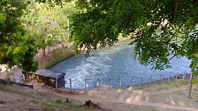 The Bisokotuwa of Kala wewa passes water through its Sorowwa where Yodha Ela starts. | |
| Specifications | |
| Length | 87 km (54 miles) |
| History | |
| Date completed | 459 AD |
| Geography | |
| Start point | Kala Wewa |
| End point | Tissa Wewa |
Yoda Ela (Giant Canal) or Jaya Ganga, an 87 km (54 mi) long single banking water canal carrying excess water from Kala Wewa reservoir to Thissa Wewa reservoir in Anuradhapura, is a construction dependent on remarkable instrumentation precision. Its gradient of 10 to 20 cm per kilometre still baffles experts today for its minute precision[1].
Construction
Yodha Ela was constructed during King Dathusena's reign in 459 AD. It is 87 km (54 mi) long[2]. It is a trans-basin diversion canal transferring water from Kala Oya Basin to Malwathu Oya Basin, but because of the mild slope to which it had been constructed. Its mild-gradient had been found to be of the order of 0.32 m (1.0 ft) drop along 1.61 km (1.00 mi). Even with the modern day survey equipment achieve the said accuracy.[3]
Functions
Yodha Ela functions in a way of a moving reservoir because of its single banking aspect which is different from the present day double banking irrigation canals'. It feeds water in an area of 470 km2 (180 sq mi) feeding 4,630 ha (11,400 acres) of paddy lands and 120 small tanks on its way from Kala Wewa to Tissa Wewa[4]