Rajanganaya Dam
| Rajanganaya Dam | |
|---|---|
 | |
| Country | Sri Lanka |
| Location | Rajanganaya |
| Coordinates | 08°08′30″N 80°13′23″E / 8.14167°N 80.22306°ECoordinates: 08°08′30″N 80°13′23″E / 8.14167°N 80.22306°E |
| Purpose | Irrigation |
| Status | Operational |
| Operator(s) | Ministry of Irrigation |
| Dam and spillways | |
| Impounds | Kala Oya |
| Length | 350 m (1,150 ft) |
| Reservoir | |
| Total capacity | 100.37×10⁶ m3 (3,545×106 cu ft) |
| Catchment area | 76,863.60 hectares (189,934.1 acres) |
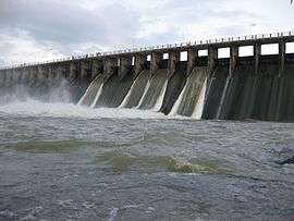
The Rajanganaya Dam (also sometimes called Rajangana) is an irrigation dam built across the Kala Oya river, at Rajanganaya, bordering the North Western and North Central provinces of Sri Lanka. The main concrete dam measures approximately 350 m (1,150 ft) and creates the Rajanganaya Reservoir, which has a catchment area of 76,863.60 hectares (189,934.1 acres) and a total storage capacity of 100.37 million cubic metres (3,545×106 cu ft).[1]
See also
References
- ↑ "Reservoirs in Sri Lanka". Ministry of Irrigation and Water Resources Management. Retrieved 6 December 2015.
External links
- "Sluice gates of Deduru Oya and Rajangana opened". News.lk. Retrieved 6 December 2015.
This article is issued from
Wikipedia.
The text is licensed under Creative Commons - Attribution - Sharealike.
Additional terms may apply for the media files.