List of dams and reservoirs in Sri Lanka

Hydroelectricity accounts for nearly half of the installed power capacity of Sri Lanka.

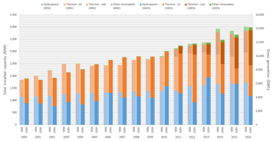
The following page lists most dams in Sri Lanka. Most of these dams are governed by the Mahaweli Authority, while the Ceylon Electricity Board operates dams used for hydroelectric power generation. Hydroelectric dams, including small hydros accounts for nearly half of the installed power capacity of Sri Lanka.

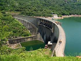
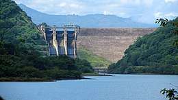
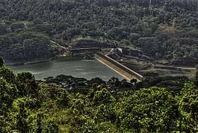
Sri Lanka is pockmarked with a large number of irrigation dams with its water resource distributed across nearly the entirety of the island for agricultural purposes via artificial canals and streams. Utilization of hydro resources for agricultural production dates back pre-Colonial era, with current crop productions now largely dependand on these water resources.

Dams in Sri Lanka

The Victoria Dam on 15 April 2011. Three days after its 26th anniversary of opening.
Upstream view of the Kotmale Dam.
Open spillways of the Rajanganaya Dam.

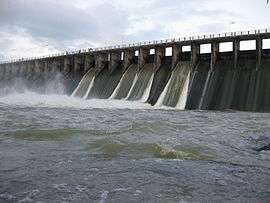
Irrigation dams with a length and height of more than 100 m (330 ft) and 10 m (33 ft) are listed, including all the state-run hydroelectric power stations. Privately owned "small-hydro" facilities (which are limited to a maximum nameplate capacity of 10 MW), are not included in this list. Nearly all hydroelectric dams are also used for providing water resource for irrigation purposes, hence for the sake of identifying the hydroelectric dams, any dam with hydroelectric involvement is stated as such in the below table, even if the primary purpose of building the dam is to retain water for irrigation.

DamLocationPurposeLength
(m)
Height
(m)
Gen.TypeRef
Bowatenna07°40′00″N 80°40′00″E / 7.66667°N 80.66667°E / 7.66667; 80.66667 (Bowatenna Dam)Hydroelectricity2263040Gravity 
Broadlands06°58′50″N 80°27′09″E / 6.98056°N 80.45250°E / 6.98056; 80.45250 (Broadlands Hydropower Project)Hydroelectricity1142435Gravity[1]
Canyon06°52′18″N 80°31′34″E / 6.87167°N 80.52611°E / 6.87167; 80.52611 (Canyon Dam)Hydroelectricity  100Arch-gravity
Castlereigh06°52′24″N 80°33′59″E / 6.87333°N 80.56639°E / 6.87333; 80.56639 (Castlereigh Dam)Hydroelectricity  50Gravity 
Deduru Oya07°43′06″N 80°16′28″E / 7.71833°N 80.27444°E / 7.71833; 80.27444 (Deduru Oya Dam)Hydroelectricity2,400201.5Embankment[2]
Dyraaba06°53′13″N 80°57′23″E / 6.88694°N 80.95639°E / 6.88694; 80.95639 (Dyraaba Dam)Hydroelectricity16550120Gravity[3]
Gal Oya07°12′37″N 81°32′10″E / 7.21028°N 81.53611°E / 7.21028; 81.53611 (Gal Oya Dam)Hydroelectricity1,1004312Embankment 
Inginimitiya07°56′40″N 80°07′54″E / 7.94444°N 80.13167°E / 7.94444; 80.13167 (Inginimitiya Dam)Irrigation4,88018N/AEmbankment 
Kalu Ganga07°33′35″N 80°50′09″E / 7.55972°N 80.83583°E / 7.55972; 80.83583 (Kalu Ganga Dam)Irrigation54667N/AGravity 
Kandalama07°53′00″N 80°41′40″E / 7.88333°N 80.69444°E / 7.88333; 80.69444 (Kandalama Dam)Irrigation1,60021N/AEmbankment 
Kantale08°21′40″N 80°59′29″E / 8.36111°N 80.99139°E / 8.36111; 80.99139 (Kantale Dam)Irrigation4,20015N/AEmbankment 
Kotmale07°03′39″N 80°35′50″E / 7.06083°N 80.59722°E / 7.06083; 80.59722 (Kotmale Dam)Hydroelectricity60087201Gravity 
Kukule Ganga06°34′48″N 80°19′37″E / 6.58000°N 80.32694°E / 6.58000; 80.32694 (Kukule Ganga Dam)Hydroelectricity1102080Gravity 
Laxapana06°55′08″N 80°29′22″E / 6.91889°N 80.48944°E / 6.91889; 80.48944 (Laxapana Dam)Hydroelectricity  75Gravity 
Lunugamwehera06°21′11″N 81°12′09″E / 6.35306°N 81.20250°E / 6.35306; 81.20250 (Lunugamwehera Dam)Irrigation  N/AEmbankment 
Maduru Oya07°38′53″N 81°12′50″E / 7.64806°N 81.21389°E / 7.64806; 81.21389 (Maduru Oya Dam)Irrigation1,09041N/AEmbankment 
Maskeliya06°50′37″N 80°32′56″E / 6.84361°N 80.54889°E / 6.84361; 80.54889 (Maskeliya Dam)Hydroelectricity  60Gravity 
Moragahakanda07°42′17″N 80°46′59″E / 7.70472°N 80.78306°E / 7.70472; 80.78306 (Moragahakanda Dam)Hydroelectricity 6525Gravity[4][5][6]
Moragolla Hydroelectricity 3530Gravity[7]
Norton06°54′50″N 80°31′18″E / 6.91389°N 80.52167°E / 6.91389; 80.52167 (Norton Dam)Hydroelectricity  50Gravity 
Nilambe07°11′18″N 80°37′52″E / 7.18833°N 80.63111°E / 7.18833; 80.63111 (Nilambe Dam)Hydroelectricity70 3.2Gravity 
Polgolla07°19′18″N 80°38′42″E / 7.32167°N 80.64500°E / 7.32167; 80.64500 (Polgolla Barrage)Hydroelectricity14414.640Gravity 
Puhulpola06°54′51″N 80°56′00″E / 6.91417°N 80.93333°E / 6.91417; 80.93333 (Puhulpola Dam)Irrigation17545NAGravity[3]
Rajanganaya08°08′30″N 80°13′23″E / 8.14167°N 80.22306°E / 8.14167; 80.22306 (Rajanganaya Dam)Irrigation  N/AEmbankment 
Randenigala07°12′00″N 80°55′30″E / 7.20000°N 80.92500°E / 7.20000; 80.92500 (Randenigala Dam)Hydroelectricity48594126Embankment 
Rambakan Oya07°33′53″N 81°27′17″E / 7.56472°N 81.45472°E / 7.56472; 81.45472 (Rambakan Oya Dam)Irrigation122524.7N/AEmbankment 
Rantembe07°12′00″N 80°57′00″E / 7.20000°N 80.95000°E / 7.20000; 80.95000 (Rantembe Dam)Hydroelectricity4204252Gravity 
Ratkinda07°30′30″N 81°03′24″E / 7.50833°N 81.05667°E / 7.50833; 81.05667 (Ratkinda Dam)Irrigation4,96025N/AEmbankment[8]
Samanala06°40′54″N 80°47′54″E / 6.68167°N 80.79833°E / 6.68167; 80.79833 (Samanala Dam)Hydroelectricity530110124Embankment 
Udawalawe06°26′02″N 80°51′15″E / 6.43389°N 80.85417°E / 6.43389; 80.85417 (Udawalawe Dam)Hydroelectricity3,900 6Embankment 
Ulhitiya07°28′20″N 81°03′17″E / 7.47222°N 81.05472°E / 7.47222; 81.05472 (Ulhitiya Dam)Irrigation  N/AEmbankment 
Upper Kotmale06°56′48″N 80°39′29″E / 6.94667°N 80.65806°E / 6.94667; 80.65806 (Upper Kotmale Dam)Hydroelectricity18035150Gravity[9][10]
Victoria07°14′29″N 80°47′05″E / 7.24139°N 80.78472°E / 7.24139; 80.78472 (Victoria Dam)Hydroelectricity520122210Arch[11]

See also

References

  1. "About the Broadlands Hydropower Project". BHPCEB.lk. Archived from the original on 4 October 2013. Retrieved 2 October 2013.
  2. P. Krishnaswamy (12 January 2014). "Deduru Oya Reservoir Project commissioning, a landmark event". Sunday Observer. Retrieved 4 November 2015.
  3. 1 2 Sriyananda, Shanika (27 March 2015). "Uma Oya Project: More damages than benefits?". Daily FT. Retrieved 1 July 2017.
  4. Principal project features of the Moragahakanda Dam and appurtenant structures, retrieved 2010-09-22
  5. Moragahakanda & Kaluganga Development Project, retrieved 2010-09-22
  6. Saudi gives Rs.5,332M for Kaluganga Project, retrieved 2010-09-22
  7. "Moragolla Hydropower". Ministry of Power and Renewable Energy. Retrieved 2 July 2017.
  8. Ratkinda/Ulhitiya Dam Archived 2009-07-28 at the Wayback Machine.
  9. Upper Kotmale Dam, retrieved 2010-08-08
  10. Upper Kotmale power project to be completed soon, retrieved 2010-08-08
  11. Victoria Dam, retrieved 2010-08-08


This article is issued from Wikipedia. The text is licensed under Creative Commons - Attribution - Sharealike. Additional terms may apply for the media files.