Tissa Wewa (Tissamaharama)
| Tissa Wewa | |
|---|---|
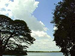 View of Tissa Wewa | |
| Location | Tissamaharama |
| Coordinates | 6°17′N 81°17′E / 6.283°N 81.283°ECoordinates: 6°17′N 81°17′E / 6.283°N 81.283°E |
| Type | Reservoir |
| Basin countries | Sri Lanka |
| Surface area | 652 acres (2.64 km²) |
| Average depth | 13 ft (4 m) |
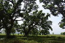
Bats on the western side of Tissa Wewa
The lake, an artificial reservoir, is thought to have been constructed in the 3rd Century BC, either by Mahanaga of Ruhuna or his successor Yatala Tissa of Ruhuna, in order to irrigate paddy lands and supply water to the flourishing city of Tissamaharama.
The lake was restored in 1871. The embankment (or bund) on the southern shore supports the Tissa-Kataragama road (B464), which is lined by old Indian rain trees planted by the British to provide shade.[1]
References
- ↑ The Rough Guide to Sri Lanka, Gavin Thomas, Rough Guides, 2012, p. 185.
This article is issued from
Wikipedia.
The text is licensed under Creative Commons - Attribution - Sharealike.
Additional terms may apply for the media files.