Turmus Ayya
| Turmus 'Ayyā | |
|---|---|
| Other transcription(s) | |
| • Arabic | ترمسعيّا |
| • Also spelled |
Turmus'ayyeh (official) Tourmous Ayyeh (unofficial) |
 | |
 Turmus 'Ayyā Location of Turmus 'Ayyā within Palestine | |
| Coordinates: 32°02′09″N 35°17′10″E / 32.03583°N 35.28611°ECoordinates: 32°02′09″N 35°17′10″E / 32.03583°N 35.28611°E | |
| Palestine grid | 177/160 |
| Governorate | Ramallah & al-Bireh |
| Government | |
| • Type | Village council |
| • Head of Municipality | Mohammed Ibrahim |
| Area | |
| • Jurisdiction | 17,606 dunams (17.6 km2 or 6.8 sq mi) |
| Population (2007) | |
| • Jurisdiction | 3,736 |
| Name meaning | Thormasia[1] |
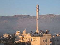
Turmus Ayya (Arabic: ترمسعيّا) is a Palestinian town located in the Ramallah and al-Bireh Governorate in the West Bank. According to the Palestinian Central Bureau of Statistics (PCBS), it had a population of 3,736 in 2007.[2]
Geography
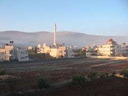
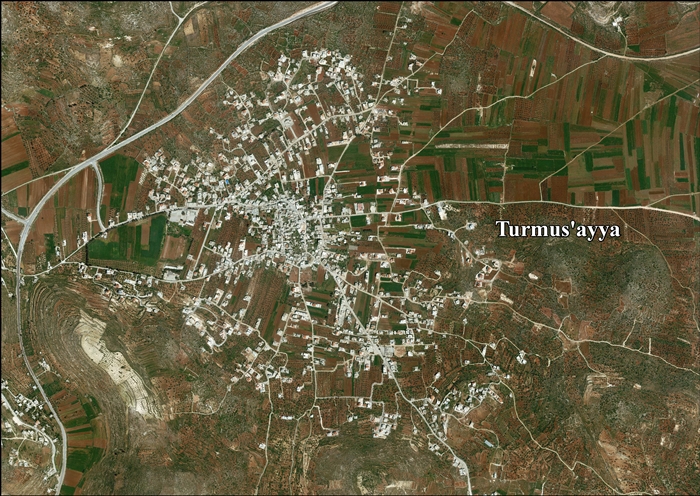
Turmus Ayya is located 22 kilometres (14 mi) northeast of the city of Ramallah. Its surrounding villages are Sinjil (سنجل), Khirbet Abu Falah (خربة ابو فلاح) and the Israeli settlement of Shilo. Its jurisdiction is about 18,000 acres (73 km2). Turmus Ayya is 720 m above sea level. It is also the northernmost town in the Ramallah District. Turmus Ayya's climate is similar to that of the central West Bank, which is rainy in the winter, and hot and humid in the summer.
Etymology
Turmus Ayya appears in older maps and reference books, such as Mustafa Murad al-Dabbagh's encyclopedia "Palestine, Our Land,” as Thorinasia. The name is broken down into three parts - Tur-Massh-Ayya: Tur means mountain, Massh is the pulp left after squeezing grapes, and Ayya means humid. Alternately, the name might come from the Latin: Terra (land) and Messiae (of Messiah), hence "Land of the Messiah."[1] or "Terra" (land) and "Mosea" (of Moses), hence, "Land of Moses".
History

Potsherds from the late Iron Age (8 -7th century B.C.E.) period and later have been found, and it is estimated that the village has existed continuously since then.[5]
Turmus Ayya is generally accepted as being the Turbasaim in Crusader sources.[6]
Just North-East of Turmus Ayya is Kh. Ras ad Deir/Deir el Fikia, believed to be the Crusader village of Dere.[7][8]
In 1145, half of the income from both villages were given to the Abbey of Mount Tabor, so that they could maintain the church at Sinjil.[9] In 1175, all three villages; Turmus Ayya, Dere and Sinjil, were transferred to the Church of the Holy Sepulchre.[10]
Ottoman era
In 1517, Turmus Ayya was incorporated into the Ottoman Empire with the rest of Palestine, and in 1596 it appeared in the tax registers as being in the Nahiya of Quds of the Liwa of Quds. It had a population of 43 households, all Muslim, and paid taxes on wheat, barley, olive trees, vineyards, fruit trees, goats and/or beehives; a total of 7,200 Akçe. 11/24 of the revenue went to a Waqf.[11]
In 1838, Edward Robinson noted that Turmus Aya was within the province of Jerusalem, but the province of Nablus was just north of it.[12] It was further noted that it was situated "on a low rocky mound in the level valley."[13]
French explorer Victor Guérin visited the village in 1870, and found here ancient cisterns, cut stones built up in the houses, a broken lintel with a garland carved upon and the fragments of a column.[14] He further noted that the village had about seven hundred inhabitants, and was administered by two sheikhs and divided into two different areas. Some ancient cisterns were almost completely dry, and women were forced to fetch water either from Ain Siloun, or Ain Sindjel.[15] An official Ottoman village list from about 1870 showed that "Turmus Aja" had a total of 88 houses and a population of 301, though the population count included men, only.[16][17]
In the Palestine Exploration Fund's Survey of Western Palestine in 1882, Turmus 'Aya was described as "a village on a low knoll, in a fertile plain, with a spring to the south. The village is of moderate size, and surrounded by fruit trees. On the south at the foot of the mound is the conspicuous white dome of the sacred place."[18]
In 1896 the population of Turmus 'aija was estimated to be about 834 persons.[19]
British Mandate era
In the 1922 census of Palestine, conducted by the British Mandate authorities, Turmus Ayya had a population of 707, all Muslim,[20] while in the 1931 census, the village had 185 occupied houses and a population of 717, all Muslims except one Christian woman.[21]
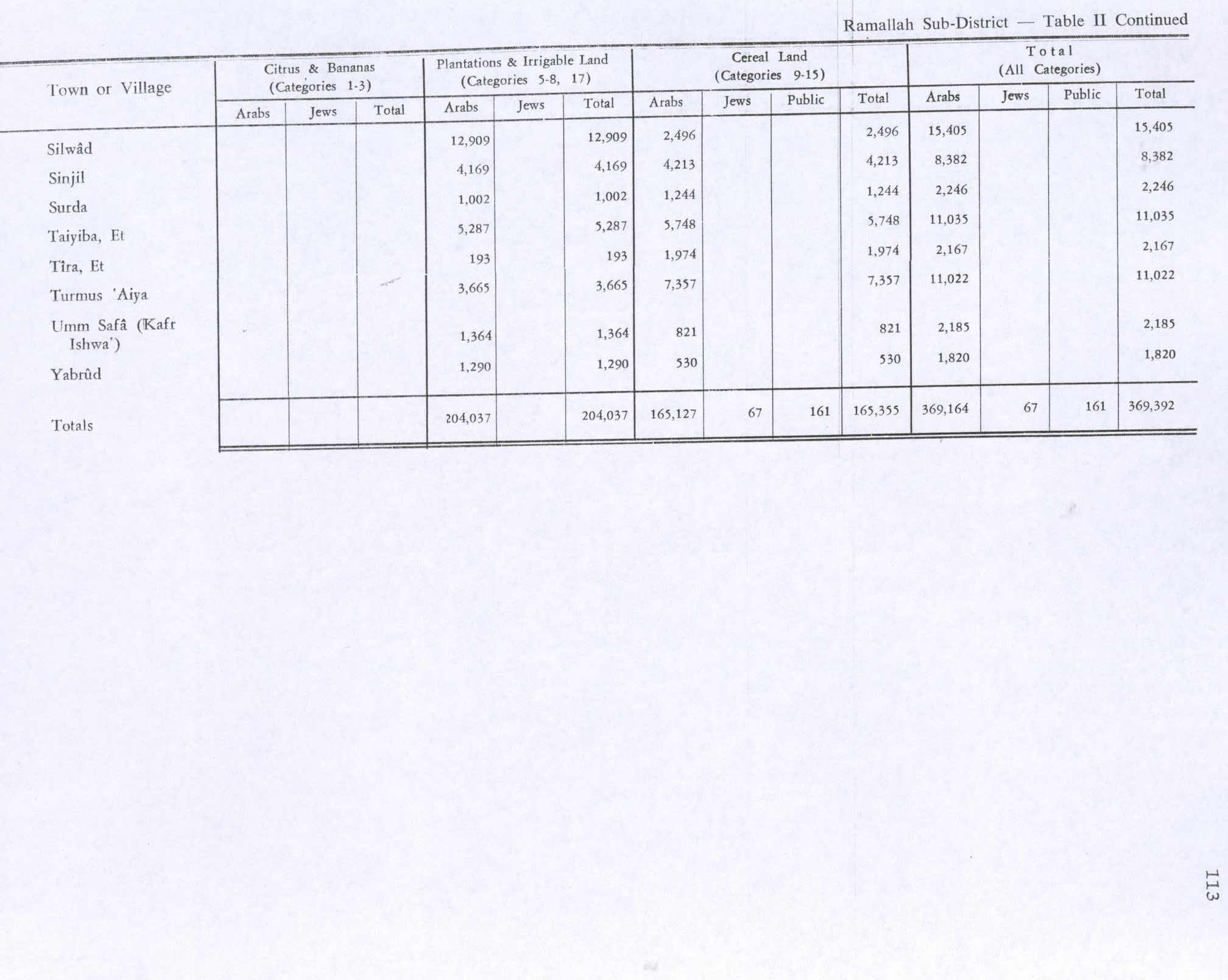
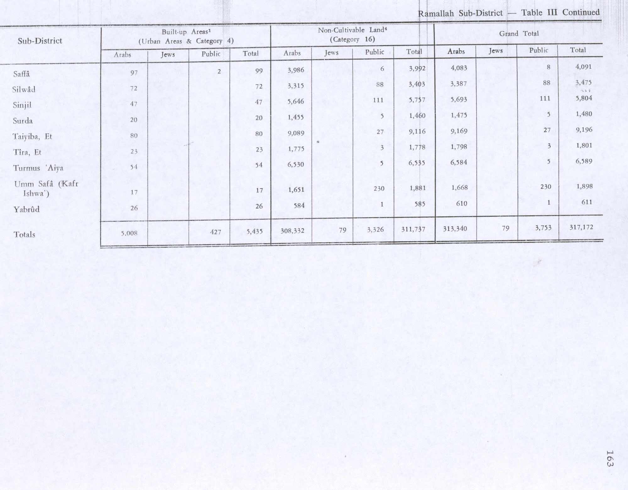
In 1945 the population was 960, all Muslim,[22] while the total land area was 17,611 dunams, according to an official land and population survey.[23] Of this, 3,665 were allocated for plantations and irrigable land, 7,357 for cereals,[24] while 54 dunams were classified as built-up areas.[25]
Jordanian era
In the wake of the 1948 Arab–Israeli War, and after the 1949 Armistice Agreements, Turmus Ayya came under Jordanian rule.
1967-present
After the Six-Day War in 1967, Turmus Ayya has been under Israeli occupation. According to an Israeli census in 1967, there were 1,562 people. By 1989, the population rose to 5,140. The original residents of Turmus Ayya come from the following clans: Abu-Awad (أبوعواد), Ijbara (اجبرا), Kük(كوك), Hazama/Nofal(حزمة) or Shalabi (شلبي).
Under the Oslo Accords of 1995, 64.7 % of village land belongs to Area B, while the remaining 35.3 % is Area C.[27] Israel has confiscated 752 dunam of village land for the Israeli settlement of Shilo, and another 372 dunams for Mizpe Rahel.[28]
In December 2014, the town was the site of the controversial death of Palestinian official Ziad Abu Ein, during a protest against Israeli occupation.[29]
Education
There are three schools in Turmus Ayya: a girls school (grades 1–12), a boys school (grades 1–12) and a co-ed school (grades 1–4). There is also a community center housing a pre-school and kindergarten.
Economy
The economy is based primarily on olive orchards and fruit trees. It is also the home of the Turmus Aya Equestrian Club.
Local services
Turmus Ayya is governed by a local council. Water is supplied by Ramallah Water Systems; electricity by Jerusalem Energy; and phone service by the Palestinian Communications Company. Turmus Ayya has a new hospital on the northern side of town (al-Muntazah). There are two mosques in the town: Masjid Abu Bakir Asadeek and the newer Masjid al Farook. An older, non-functioning mosque is Al-Masjid Alqadeem ("the old mosque)."
References
- 1 2 Palmer, 1881, p. 246
- ↑ 2007 PCBS Census. Palestinian Central Bureau of Statistics. p.112.
- ↑ Savignac, 1913, pp. 106–111
- ↑ Michon, 1913, pp. 111–118
- ↑ Finkelstein, 1997, pp. 651-652
- ↑ Röhricht, 1887, p. 206; cited in Finkelstein, 1997, p. 651
- ↑ "Foundations and heaps of stones. Ruins of a monastery and chapel, the masonry in the walls rude, the stones drafted in some cases with a rustic boss. The place appears to be Crusading work;" Conder and Kitchener, 1882, SWP II, p. 331
- ↑ Pringle, 1993, p. 196
- ↑ Röhricht, 1893, RHH, p. 59, No. 234; cited in Pringle, 1993, p. 196
- ↑ Röhricht, 1893, RHH, p. 141, No. 529; cited in Pringle, 1993, p. 196
- ↑ Hütteroth and Abdulfattah, 1977, p. 113.
- ↑ Robinson and Smith, 1841, vol. 3, p. 83
- ↑ Robinson and Smith, 1841, vol. 3, p 85
- ↑ Guérin, 1875, p. 28, as translated in Conder and Kitchener, 1882, SWP II, p. 378
- ↑ Guérin, 1875, p. 28
- ↑ Socin, 1879, p. 162 It was located in the Beni Murra district
- ↑ Hartmann, 1883, p. 115 noted 82 houses
- ↑ Conder and Kitchener, 1882, SWP II, p. 292
- ↑ Schick, 1896, p. 122
- ↑ Barron, 1923, Table VII, Sub-district of Ramallah, p. 17
- ↑ Mills, 1932, p. 51.
- ↑ Government of Palestine, Department of Statistics, 1945, p. 26
- ↑ Government of Palestine, Department of Statistics. Village Statistics, April, 1945. Quoted in Hadawi, 1970, p. 65
- ↑ Government of Palestine, Department of Statistics. Village Statistics, April, 1945. Quoted in Hadawi, 1970, p. 113
- ↑ Government of Palestine, Department of Statistics. Village Statistics, April, 1945. Quoted in Hadawi, 1970, p. 163
- ↑ Government of Jordan, Department of Statistics, 1964, p. 24
- ↑ Turmus’ayya Town Profile, ARIJ, p. 16
- ↑ Turmus’ayya Town Profile, ARIJ, p. 17
- ↑ Palestine’s land conflict: Death in the olive groves, economist.com.
Bibliography
- Barron, J. B., ed. (1923). Palestine: Report and General Abstracts of the Census of 1922. Government of Palestine.
- Conder, C.R.; Kitchener, H. H. (1882). The Survey of Western Palestine: Memoirs of the Topography, Orography, Hydrography, and Archaeology. 2. London: Committee of the Palestine Exploration Fund.
- Finkelstein, I.; Lederman, Zvi, eds. (1997). Highlands of many cultures. Tel Aviv: Institute of Archaeology of Tel Aviv University Publications Section. ISBN 965-440-007-3.
- Government of Jordan, Department of Statistics (1964). First Census of Population and Housing. Volume I: Final Tables; General Characteristics of the Population (PDF).
- Government of Palestine, Department of Statistics (1945). Village Statistics, April, 1945.
- Guérin, V. (1869). Description Géographique Historique et Archéologique de la Palestine (in French). 1: Judee, pt. 2. Paris: L'Imprimerie Nationale.
- Hadawi, S. (1970). Village Statistics of 1945: A Classification of Land and Area ownership in Palestine. Palestine Liberation Organization Research Center.
- Hartmann, M. (1883). "Die Ortschaftenliste des Liwa Jerusalem in dem türkischen Staatskalender für Syrien auf das Jahr 1288 der Flucht (1871)". Zeitschrift des Deutschen Palästina-Vereins. 6: 102–149.
- Hütteroth, Wolf-Dieter; Abdulfattah, Kamal (1977). Historical Geography of Palestine, Transjordan and Southern Syria in the Late 16th Century. Erlanger Geographische Arbeiten, Sonderband 5. Erlangen, Germany: Vorstand der Fränkischen Geographischen Gesellschaft. ISBN 3-920405-41-2.
- Michon, E. (1913). "Sarcophage representant Bacchus et les Genies des saisons decouvert a Tourmous'aya". Revue Biblique. 10: 111–118.
- Mills, E., ed. (1932). Census of Palestine 1931. Population of Villages, Towns and Administrative Areas. Jerusalem: Government of Palestine.
- Neubauer, A. (1868). La géographie du Talmud : mémoire couronné par l'Académie des inscriptions et belles-lettres (in French). Paris: Lévy. (p. 279; but see Abel 1938:257; Elitzur 1985b.)
- Palmer, E. H. (1881). The Survey of Western Palestine: Arabic and English Name Lists Collected During the Survey by Lieutenants Conder and Kitchener, R. E. Transliterated and Explained by E.H. Palmer. Committee of the Palestine Exploration Fund.
- Pringle, Denys (1993). The Churches of the Crusader Kingdom of Jerusalem: A-K (excluding Acre and Jerusalem). I. Cambridge University Press. ISBN 0 521 39036 2.
- Robinson, E.; Smith, E. (1841). Biblical Researches in Palestine, Mount Sinai and Arabia Petraea: A Journal of Travels in the year 1838. 3. Boston: Crocker & Brewster.
- Röhricht, R. (1887). "Studien zur mittelalterlichen Geographie und Topographie Syriens". Zeitschrift des Deutschen Palästina-Vereins. 10: 195–344.
- Röhricht, R. (1893). (RRH) Regesta regni Hierosolymitani (MXCVII-MCCXCI) (in Latin). Berlin: Libraria Academica Wageriana.
- Saulcy, L.F. de (1854). Narrative of a journey round the Dead Sea, and in the Bible lands, in 1850 and 1851. 1, new edition. London: R. Bentley. (Saulcy, 1854, vol 1, p. 104)
- Savignac, R. (1913). "Decouvertes a Tourmous'aya". Revue Biblique. 10: 106–111.
- Schick, C. (1896). "Zur Einwohnerzahl des Bezirks Jerusalem". Zeitschrift des Deutschen Palästina-Vereins. 19: 120–127.
- Socin, A. (1879). "Alphabetisches Verzeichniss von Ortschaften des Paschalik Jerusalem". Zeitschrift des Deutschen Palästina-Vereins. 2: 135–163.
External links
- Welcome To Turmus 'Ayya
- Turmus ‘Ayya, Welcome to Palestine
- Survey of Western Palestine, Map 14: IAA, Wikimedia commons
- Turmusayya Town (Fact Sheet), Applied Research Institute - Jerusalem (ARIJ)
- Turmus’ayya Town Profile, Applied Research Institute - Jerusalem, (ARIJ)
- Turmus’ayya Aerial photo, Applied Research Institute - Jerusalem, (ARIJ)
- or Palestinian Americans, home brings little freedom March 31, 2013, The National
- http://www.turmusaya.com
- In West Bank, Peace Symbol Now Signifies Struggle, Isabel Kershner, October 12, 2010, The New York Times
- Land confiscation in Turmus 'Aya village, POICA, 23, December, 2003,
