Mazgirt
| Mazgirt | |
|---|---|
 Mazgirt | |
| Coordinates: 39°01′18″N 39°36′30″E / 39.02167°N 39.60833°ECoordinates: 39°01′18″N 39°36′30″E / 39.02167°N 39.60833°E | |
| Country | Turkey |
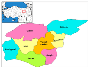
| Province | Tunceli |
| Government | |
| • Mayor | Tekin Türkel (ÖDP) |
| • Kaymakam | Haluk Çakmak |
| Area[1] | |
| • District | 673.51 km2 (260.04 sq mi) |
| Elevation | 1,447 m (4,747 ft) |
| Population (2012)[2] | |
| • Urban | 2,107 |
| • District | 8,622 |
| • District density | 13/km2 (33/sq mi) |
| Post code | 628xx |
| Climate | Dsa |
| Website | www.mazgirt.bel.tr |
Mazgirt, Kurdish: Mêzgir or Mazgêrd) is a small city and its surrounding district in Tunceli Province of Turkey. The city has a population of 1,712, most of which are Alevi. The mayor is Tekin Türkel (ÖDP). The town has a number of interesting buildings, such as an abandoned castle,[3] an old Mosque, and an Armenian Church which is soon to be renovated.[4][5][6]
References
- ↑ "Area of regions (including lakes), km²". Regional Statistics Database. Turkish Statistical Institute. 2002. Retrieved 2013-03-05.
- ↑ "Population of province/district centers and towns/villages by districts - 2012". Address Based Population Registration System (ABPRS) Database. Turkish Statistical Institute. Retrieved 2013-02-27.
- ↑ 39.023698, 39.600318
- ↑ https://amongarmenianruins.wordpress.com/2015/09/02/to-mazgirt/
- ↑ http://armenpress.am/eng/news/798987/armenian-church-in-dersim-to-be-renovated.html
- ↑ https://www.google.com/maps/@39.022818,39.60567,3a,75y,90t/data=!3m8!1e2!3m6!1s25043068!2e1!3e10!6s%2F%2Fstorage.googleapis.com%2Fstatic.panoramio.com%2Fphotos%2Fsmall%2F25043068.jpg!7i2816!8i2112
This article is issued from
Wikipedia.
The text is licensed under Creative Commons - Attribution - Sharealike.
Additional terms may apply for the media files.