Tremont, Bronx
| Tremont | |
|---|---|
| Neighborhood of the Bronx | |
 The Grand Concourse runs through the neighborhood. | |
|
Location in New York City | |
| Coordinates: 40°51′00″N 73°54′22″W / 40.85°N 73.906°WCoordinates: 40°51′00″N 73°54′22″W / 40.85°N 73.906°W | |
| Country |
|
| State |
|
| City |
|
| Borough |
|
| Area[1] | |
| • Total | 0.78 km2 (0.301 sq mi) |
| Population (2011)[1] | |
| • Total | 24,739 |
| • Density | 32,000/km2 (82,000/sq mi) |
| Economics | |
| • Median income | $26,290 |
| Ethnicity[2] | |
| • Hispanic | 67.5% |
| • Black | 27.1% |
| • White | 1.3% |
| • Asian | 2% |
| • Others | 2.1% |
| ZIP codes | 10453, 10457 |
| Area code | 718, 347, 929, and 917 |
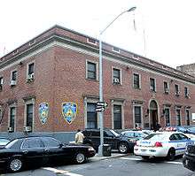
Tremont, is a residential neighborhood in the West Bronx, New York City. The neighborhood is part of Bronx Community Board 6. Its boundaries, starting from the north and moving clockwise are: East 181st Street to the north, Third Avenue to the east, the Cross-Bronx Expressway to the south, and the Grand Concourse to the West. East Tremont Avenue is the primary thoroughfare through Tremont. The local subway is the IND Concourse Line (B and D trains), operating along the Grand Concourse. Zip codes include 10453 and 10457. The area is patrolled by the NYPD's 48th Precinct located at 450 Cross Bronx Expressway within Tremont.[3]
Demographics
Tremont has a population of around 24,739. The neighborhood is now predominantly Dominican, with a significant longstanding Puerto Rican and African American population.[1][4]
Land use and terrain
Tremont is dominated by 5 and 6-story apartment houses. The total land area is less than 1-square-mile (2.6 km2). The area is elevated above adjacent areas and is very hilly. Stair streets connect areas located at different elevations.
Morris Avenue Historic District
The landmarked Morris Avenue Historic District lines Morris Avenue between East Tremont and East 179th Street. The district consists of attached brownstones.[5][6]
Etymology
Rather than having come from a colonial settlement, the name "Tremont" was invented by a postmaster in the 1800s, derived from the three ("tre") neighborhoods of Mount Eden, Mount Hope, and Fairmount in the west-central Bronx.[7]
Education
Public:
- PS 9: Ryer (East 183rd Street and Ryer Avenue)
- PS 28: Mount Hope (Mount Hope Place and Anthony Avenue)
- PS 79: Creston (East 181st Street and Creston Avenue)
- PS 163: Arthur Alonso Schomburg (East 180th Street and Webster Avenue)
- PS 173: (Walton Avenue and Mount Hope Place)
- PS/MS 279: Captain Manuel Rivera (East 181st Street and Walton Avenue)
- MS 117: Joseph H. Wade (East 176th Street and Morris Avenue)
- MS 331: The Bronx School of Science Inquiry and Investigation (West Tremont Avenue and Davidson Avenue)
- MS 391: Angelo Patri (East 182nd Street and Webster Avenue)
- PS 70: Max Schonberg School (Weeks Avenue bet. E. 173rd and E. 174th Streets)
Parochial:
- St. Margaret Mary School (121 East and 177th Street)[8]
Transportation
The following MTA Regional Bus Operations bus routes serve Tremont:[9]
- Bx1: to Riverdale or Third Avenue–138th Street station (6 and <6> trains, via Grand Concourse)
- Bx2: to Kingsbridge Heights or Third Avenue–138th Street station (6 and <6> trains, via Grand Concourse)
- Bx36: to Castle Hill or George Washington Bridge Bus Terminal (via 180th Street)
- Bx40: to SUNY Maritime College or Morris Heights (via Tremont and Burnside Avenues)
- Bx41 and Bx41 SBS: to Gun Hill Road station (2 and 5 trains) or Third Avenue–149th Street station (2 and 5 trains, via Webster Avenue)
- Bx42: to Throgs Neck or Morris Heights (via Tremont and Burnside Avenues)
The following New York City Subway stations serve Tremont:[10]
- Tremont Avenue station (B and D trains)
- 182nd–183rd Streets station (B and D trains)
- 176th Street station (4 train)
- Burnside Avenue station (4 train)
- 183rd Street station (4 train)
The Metro-North Railroad's Harlem Line also serves Tremont at the Tremont station.
References
- 1 2 3 "Mount Hope neighborhood in New York". Retrieved 13 September 2015.
- ↑ "Center for Urban Research". Archived from the original on 13 October 2015. Retrieved 14 September 2015.
- ↑ "46th Precinct".
- ↑ "Bronx Community District 5" (PDF). Archived from the original (PDF) on 4 March 2016. Retrieved 14 September 2015.
- ↑ Morris Avenue Historic District
- ↑ "Morris Avenue Historic District Designation Report" (PDF). Retrieved 14 September 2015.
- ↑ "Tremont Park". Retrieved 14 September 2015.
- ↑ "St. Margaret Mary". Retrieved 14 September 2015.
- ↑ "Bronx Bus Map" (PDF). Metropolitan Transportation Authority. September 2017. Retrieved April 24, 2018.
- ↑ "Subway Map" (PDF). Metropolitan Transportation Authority. January 18, 2018. Retrieved January 18, 2018.
| South Bronx |  | |
|---|---|---|
| West Bronx | ||
| East Bronx | ||
| Related areas |
| |