Crotona Park East, Bronx
| Crotona Park East | |
|---|---|
| Neighborhood of the Bronx | |
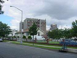 Ranch style homes along Charlotte Street | |
|
Location in New York City | |
| Coordinates: 40°50′20″N 73°53′42″W / 40.839°N 73.895°WCoordinates: 40°50′20″N 73°53′42″W / 40.839°N 73.895°W | |
| Country |
|
| State |
|
| City |
|
| Borough |
|
| Community District | Bronx 3[1] |
| Area[2] | |
| • Total | 1.27 km2 (0.491 sq mi) |
| Population (2011)[2] | |
| • Total | 37,075 |
| • Density | 29,000/km2 (76,000/sq mi) |
| Economics | |
| • Median income | $26,509 |
| Ethnicity[3] | |
| • Hispanic | 65.3% |
| • Black | 32% |
| • White | 0.9% |
| • Asian | 0.6% |
| • Others | 1.2% |
| ZIP codes | 10459, 10460 |
| Area code | 718, 347, 929, and 917 |
Crotona Park East, also known as Crotona (not to be confused with Crotona Avenue in nearby East Tremont) or East Morrisania, is a residential neighborhood geographically located in the southwest Bronx in New York City. The neighborhood is part of Bronx Community Board 3.[4] Its boundaries, starting from the north and moving clockwise are: the Cross-Bronx Expressway to the north, the Bronx River to the east, East 167th Street to the south, and Crotona/Prospect Avenues to the west. Southern Boulevard is the primary thoroughfare through the area. Zip codes include 10459 and 10460. The area is patrolled by the NYPD's 42nd Precinct[5] located at 830 Washington Ave in Morrisania. NYCHA property in the area is patrolled by P.S.A. 7 at 737 Melrose Avenue in the Melrose section of the Bronx. Crotona Park East is considered part of the socioeconomic South Bronx.
Demographics
Crotona Park East is a low-income neighborhood with a population of around 37,075. The neighborhood predominantly consists of Latin Americans and African Americans. The vast majority of households are renter-occupied, 93.5% of all housing. Almost half of the population lives below the federal poverty line.[2]
Land use and terrain
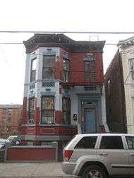
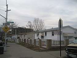
Crotona Park East is dominated by public housing projects and newly constructed subsidized attached multi-unit townhouses and apartment buildings, although tenement buildings, older multi-unit homes, and vacant lots are also present. Most of the original housing stock was structurally damaged by arson and were eventually razed by the city. The total land area is less than a square mile. The terrain is somewhat hilly.
Low-income public housing projects
There are eight NYCHA properties located in Crotona Park East.[6]
- Bryant Avenue-East 174th Street; one 6-story building
- East 173rd Street-Vyse Avenue; seven buildings, 3 stories tall
- Hoe Avenue-East 173rd Street; one 6-story building
- Murphy Houses; two 20-story buildings
- Prospect Avenue M.H.O.P. (Multi Family Homeownership Program); one rehabilitated 5-story tenement building
- West Farms Square Rehab; four rehabilitated tenement buildings, 6 stories tall
- West Farms Square (Conventional); one 5-story rehabilitated tenement building
- West Farms Square M.H.O.P. (Multi Family Homeownership Program); two rehabilitated tenement buildings, 5 and 6 stories tall
History
From 1670, the land of the neighborhood was the estate of the Morris family in Westchester County.
In the 1970s, Crotona Park East and many other low income sections of the New York City were being ravaged by arson. By the 1980s, the South Bronx had become a national symbol of urban decay; Charlotte Street, a street in the neighborhood's heart, had decayed the worst.[7] The area was filled with many burned-out tenement buildings, empty lots, and arsons happening nearly every day, as more than 66% of residents left the area.[8] On October 5, 1977, then-President Jimmy Carter visited Charlotte Street, declaring the South Bronx to be the worst neighborhood in the United States.[9] A year later, the city still had not renovated Charlotte Street.[7] The urban decay of Charlotte Street was used as one of the symbolic locations for the 1981 film Wolfen.[10][11]
Community groups such as Banana Kelly CIA Inc., the Mid-Bronx Desperadoes, and SEBCO (South East Bronx Community Organization) were helping to maintain existing buildings which were structurally intact after fires.[12][13][14] They played a pivotal role in the construction of subsidized multi-family homes and apartment buildings in most of Crotona Park East. The subsidized homes built along Charlotte Street during the late 1980s in Crotona Park East, which originally cost $50,000[8] were the first and still are the only ranch style homes in the South Bronx today; these homes are now worth over $500,000. This type of housing was selected due to its desirable traits. Today they are home to many African American and Puerto Rican families. The funding for these homes was provided in part by former Assemblyman Louis Niñé, in whose honor Wilkins Avenue was renamed "Louis Niñé Boulevard", following his death in 1983.[8]
Education
Schools include:
- PS 50: Clara Barton (East 172nd Street and Vyse Avenue)
- PS 61/MS 190: Francisco Oller (Charlotte Street and Crotona Park East)
- PS 66: Daniel Boone (Jennings Street and Boone Avenue)
- PS 134: George Frederic Bristow (Freeman and Bristow Streets)
- IS 98: Herman Ridder (East 173rd Street and Boston Road)
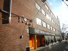
- PS 271: East Bronx Academy for the Future
Transportation
The following MTA Regional Bus Operations bus routes serve Crotona Park East:[15]
- Bx11: to Simpson Street station or George Washington Bridge Bus Terminal (via 170th Street–Claremont Parkway)
- Bx17: to Fordham Plaza Bus Terminal or Port Morris (via Prospect–Crotona Avenues)
- Bx19: to New York Botanical Gardens or Riverbank State Park (via 149th Street–Southern Boulevard)
- Bx21: to Westchester Square station or Third Avenue–138th Street station (via Boston Road–Morris Park Avenue)
- Bx27: to Clason Point (via Rosedale Avenue)
- Bx35: to Simpson Street station or George Washington Bridge Bus Terminal (via 167th Street)
- Bx36: to Castle Hill or George Washington Bridge Bus Terminal (via 180th Street)
The following New York City Subway stations serve Crotona Park East:[16]
- 174th Street (2 and 5 trains)
- Freeman Street (2 and 5 trains)
- West Farms Square–East Tremont Avenue (2 and 5 trains)
References
- ↑ "NYC Planning | Community Profiles". communityprofiles.planning.nyc.gov. New York City Department of City Planning. Retrieved 25 February 2018.
- 1 2 3 "Crotona Park East neighborhood in New York". Retrieved 18 August 2015.
- ↑ "Center for Urban Research". Archived from the original on 13 October 2015. Retrieved 18 August 2015.
- ↑ "Bronx Community District 3" (PDF). Retrieved 12 October 2015.
- ↑ "42nd Precinct". Retrieved 12 October 2015.
- ↑ NYCHA Archived May 25, 2015, at the Wayback Machine.
- 1 2 The South Bronx Through a New Lens - NY Times
- 1 2 3 The greatest real estate turnaround - CNN
- ↑ When Presidents Visited the South Bronx - NY Times
- ↑ "Faces in the Rubble". The New York Times. Retrieved 12 October 2015.
- ↑ "Out of Blight, a Step-Up Neighborhood". The New York Times. Retrieved 12 October 2015.
- ↑ Banana Kelly CIA, Inc.
- ↑ SEBCO
- ↑ Mid-Bronx Desperadoes
- ↑ "Bronx Bus Map" (PDF). Metropolitan Transportation Authority. September 2017. Retrieved April 24, 2018.
- ↑ "Subway Map" (PDF). Metropolitan Transportation Authority. January 18, 2018. Retrieved January 18, 2018.
External links
| Wikimedia Commons has media related to Crotona Park East, Bronx. |
| South Bronx |  | |
|---|---|---|
| West Bronx | ||
| East Bronx | ||
| Related areas |
| |