Parkchester, Bronx
| Parkchester | |
|---|---|
| Neighborhood of the Bronx | |
|
Location in New York City | |
| Coordinates: 40°50′20″N 73°51′36″W / 40.839°N 73.86°WCoordinates: 40°50′20″N 73°51′36″W / 40.839°N 73.86°W | |
| Country |
|
| State |
|
| City |
|
| Borough |
|
| Community District | The Bronx 9[1] |
| Area[2] | |
| • Total | 0.96 km2 (0.370 sq mi) |
| Population (2010)[3] | |
| • Total | 29,821 |
| • Density | 31,000/km2 (81,000/sq mi) |
| Economics | |
| • Median income | $41,075 |
| Ethnicity[4] | |
| • Hispanic | 38.1% |
| • Black | 42.8% |
| • White | 3.7% |
| • Asian | 12.5% |
| • Others | 2.9% |
| ZIP codes | 10462 |
| Area code | 718, 347, 929, and 917 |
| Website |
www |
Parkchester is a planned community originally developed by the Metropolitan Life Insurance Company and located in the southeast Bronx, New York City. The neighborhood is part of Bronx Community Board 9. Its boundaries, starting from the north and moving clockwise, are East Tremont Avenue to the north, Castle Hill Avenue to the east, East 177th Street[5]-Westchester Avenue to the south (Westchester Avenue is the southern border east of Metropolitan Avenue), and White Plains Road to the west. Metropolitan Avenue is the primary thoroughfare through Parkchester. The 6 and <6> trains of the New York City Subway operate along Westchester Avenue. The local ZIP code is 10462. The neighborhood is patrolled by the New York City Police Dept 43rd Precinct[6] located at 900 Fteley Avenue in Soundview. The privately owned housing complex is patrolled by Parkchester Department of Public Safety. New York City Housing Authority (NYCHA) property in the area is patrolled by PSA 8 at 2794 Randall Avenue in Throggs Neck.
History
The housing development has the same origins as Stuyvesant Town–Peter Cooper Village, and Riverton Houses in Manhattan, which were also originally developed and owned by MetLife. The name was later unofficially applied to the entire neighborhood surrounding the apartment complex. The name "Parkchester" itself was derived from the two neighborhoods on each side of the site of the housing development — Park Versailles[7] and Westchester Heights.[8][9]
MetLife displayed an intricate scale model of the proposed development at the 1939 New York World's Fair. The model showed all of the buildings and facilities, and was accurate down to inclusion of each of the 66,000 windows in the complex. The 51 groups of buildings were planned to house 12,000 families.[10]
The Parkchester residential development was originally designed and operated as a self-contained rental community for middle-class families new to home ownership. To that end, there is an abundance of worker- and family-oriented resources, including access to transportation, nearby schools and churches, retail shopping space, and proximity to a major medical center.
It was built from 1939 to 1942 (despite emergency building restrictions during World War II) on the farmland of the Catholic Protectory, a home for orphaned and troubled boys conducted by the Brothers of the Christian Schools, which relocated to Lincolndale (and still exists in) Westchester County. In 1974, approximately one-third of the complex was converted to condominiums, with the remaining portion, now Parkchester South Condominium converted later, in 1986. The complex is best known for its broad, tree-lined walkways between the distinctive red-brown buildings, and for its Works Progress Administration-style terracotta decorations on the buildings, that represent animal and human figures of many types. Many of these are the work of sculptor Joseph Kiselewski.[11]
It was a welcome affordable haven for returning WWII vets and their burgeoning families in the early 1940s. While racially segregated, it peacefully housed people from all religious backgrounds.
In 2015 Parkchester celebrated its 75th anniversary with a family event on the Parkchester North Ball Field.[12]
Parkchester Department of Public Safety
Parkchester Department of Public Safety protects to the residents, visitors, and property of the Parkchester Housing condominiums.
Land use
_(14764732012).jpg)
Parkchester is composed of 171 four-sided brick buildings, either eight or 13 stories in height and numbered M (for Main) through 7 and M through 12, respectively. The 13 story buildings have dual elevators positioned side-by-side, the eight-story buildings have but one. Some buildings even have a Terrace level - apartments that are located on the ground floor and noted by the T in front of the apartment letter, i.e., TA, TB, etc. These apartments differ from all others in the community in that they have an additional screened door in the living room section of the apartment that leads out onto a concrete patio where tenants usually put patio/lawn furniture.
The surrounding area, commonly referred to as "Parkchester," is dominated by multi-unit private homes, as well as rental units in buildings unrelated to Parkchester. Retail locations are interspersed throughout the neighborhood as well as along Starling Avenue, McGraw Avenue, Metropolitan Avenue, Tremont Avenue, Unionport Road, and White Plains Road; the latter four streets are considered the backbones of the area.
Points of interest include:
- American Theater, formerly Loews American, established in 1939—and most recently operated by Bow Tie Cinemas as a seven-screen multiplex; ceased operating in 2013[13] CLOSED
- Macy's Department Store, the first branch store since 1941
- Zaro's Bakery, established in 1959, temporarily closed in 2015, reopened its doors in 2017 close to its original location.[14][15][16][17][18][19]
There are two subsections of the neighborhood. Parkchester Apartment Complex is a subsection of Parkchester. Its boundaries, starting from the north and moving clockwise, are East Tremont Avenue to the north, Castle Hill Avenue to the east, McGraw Avenue to the south, and White Plains Road to the west. The apartment complex has recently undergone gut renovations of many of their apartments.[20] Additionally, Stratton Park is on the west part of Parkchester. Its boundaries, starting from the north and moving clockwise, are the Amtrak Northeast Corridor to the west and north, White Plains Road to the east, and East 177th Street (the Cross-Bronx Expressway service road) to the south. Its zip code is 10460, and its residents consider themselves as part of Parkchester.
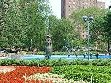
At the heart of Parkchester is the 2 acres (0.81 ha) Aileen B. Ryan Oval, formerly Metropolitan Oval.[21]
Artwork
Parkchester was designed with aesthetics in mind as evidenced by intricate patterns of brickwork. The development contains 500 terra cotta statuettes and 600 plaques such as bullfighters, animal figurines, soldiers, mermaids and Native American chiefs created by sculptor Joseph Kiselewski. They adorn the entrances and can also be seen high on the corners of the taller buildings.[11] In the Aileen B. Ryan Oval, a fountain, named "Fantasia," created by sculptor Raymond Granville Barger, was installed in 1941 and is often the backdrop of photographs.[22] A small collection photographs of the sculptures can be found in "Forgotten New York."[23]
Demographics
Based on data from the 2010 United States Census, the population of Parkchester was 29,821, an increase of 468 (1.6%) from the 29,353 counted in 2000. Covering an area of 210.76 acres (85.29 ha), the neighborhood had a population density of 141.5 inhabitants per acre (90,600/sq mi; 35,000/km2).[3]
The racial makeup of the neighborhood was 42.8% (12,765) African American, 12.4% (3,721) Asian, 3.7% (1,105) Non-Hispanic White, 0.2% (73) Native American, 0.0% (11) Pacific Islander, 0.6% (171) from other races, and 2.0% (611) from two or more races. Hispanic or Latino of any race were 38.1% (11,364) of the population.[4]
The Parkchester apartment complex includes a significant South Asian population: Pakistani, Bangladeshi, Indian, including Catholics, Muslims, and Hindus. There are also a number of Italian, Polish, Irish, Eritrean and Albanian residents. The Asian residents include Thais, Chinese, Japanese, Vietnamese, Filipinos, Burmese, and Cambodians. Parkchester also is home to a large and longstanding population of Puerto Ricans, like Luis R. Sepulveda who represents the area in the New York State Assembly and has his office on Westchester Avenue. Parkchester has one of the highest concentration of Puerto Ricans in New York City, as is it situated between Soundview and Castle Hill, which are also notable for having a significantly denser Puerto Rican population in comparison to other parts of the Bronx or the city as a whole. While the population is approximately over 40% African American and 38% Latino, the complex once had a whites-only policy. The resident population of the Parkchester apartment complex reflects a broad age distribution and the changing ethnic makeup of the Bronx.[2][24]
Transportation
The following MTA Regional Bus Operations bus routes serve Parkchester:[25]
- Bx4/Bx4A: to Westchester Square station or Third Avenue – 149th Street (via Westchester Avenue)
- Bx22: to Bedford Park (Bronx High School of Science) or Castle Hill (via Castle Hill Avenue)
- Bx36: to Castle Hill or George Washington Bridge Bus Terminal (via 180th Street)
- Bx39: to Wakefield – 241st Street subway station or Clason's Point (via White Plains Road)
- Bx40/42:
- Bx40: to SUNY Maritime College or Morris Heights (via Tremont-Burnside Avenues)
- Bx42: to Throgs Neck or Morris Heights (via Tremont-Burnside Avenues)
- Q44 SBS: to Jamaica or West Farms (via East 177th Street, the Cross Bronx Expressway service roads) and Main Street)
- BxM6: express to Midtown Manhattan (via Metropolitan Avenue)
The following New York City Subway station serves Parkchester:[26]
- Parkchester (6 and <6> trains)
Schools
- Castle Hill Middle School, a public middle school situated on St Raymond Avenue and Purdy Street, that educates students in grades 6–8. Formerly a troubled school known as JHS 127, it is now split into 7 different learning communities in order for students to get higher grades.[27]
- St. Raymond Academy for Girls, a private high school situated on Castle Hill Avenue, that educates students in grades 9–12
- St. Raymond Elementary School, a private elementary school and middle school situated on Purdy Street; it educates students in pre-kindergarten to grade 8
- PS 106, a public elementary school located at 2120 St. Raymond Avenue for grades 1–5.
- St. Helena Elementary, a private pre-school, elementary school, and middle school situated on Benedict Avenue that educates students from pre-k to 8th grade.
- Bronx Charter School for Excellence, a charter school located on Benedict Avenue that educates students from kindergarten to 5th grade.
In popular culture
- Parkchester was the filming location for part of the Sporty Thievz 1998 video "No Pigeons." Extras were featured circling a red car parked in front of the Loews American (later known as just the American) theater on East Avenue.
- Parkchester was featured in the film Doubt (2008), during the scene when Sr. Aloysius is walking with Mrs. Miller behind the building located at 2051 St. Raymond Avenue.[28]
See also
References
- ↑ "NYC Planning | Community Profiles". communityprofiles.planning.nyc.gov. New York City Department of City Planning. Retrieved 4 March 2018.
- 1 2 "Parkchester neighborhood in New York". Retrieved 23 October 2015.
- 1 2 Table PL-P5 NTA: Total Population and Persons Per Acre - New York City Neighborhood Tabulation Areas*, 2010, Population Division - New York City Department of City Planning, February 2012. Accessed June 16, 2016.
- 1 2 Table PL-P3A NTA: Total Population by Mutually Exclusive Race and Hispanic Origin - New York City Neighborhood Tabulation Areas*, 2010, Population Division - New York City Department of City Planning, March 29, 2011. Accessed June 14, 2016.
- ↑ http://legistar.council.nyc.gov/LegislationDetail.aspx?ID=1709698&GUID=9518C471-1983-4D22-82B5-15CE7EF4D9A4&Options=&Search=
- ↑ "43 Precinct". Retrieved 23 October 2015.
- ↑ Pollak, Michael. "F.Y.I.: A Key to the Past" (section: "Versailles in the Bronx"), The New York Times, January 30, 2009
- ↑ Frattini, Dave. The Underground Guide to New York City Subways (Macmillan, 2000) ISBN 0-312-25384-2, ISBN 978-0-312-25384-4, p. 330
- ↑ The Columbia Gazetteer of North America Archived 2005-09-13 at the Wayback Machine. (Columbia University Press, 2000), via Bartleby.com
- ↑ "MODEL OF HOUSING DISPLAYED AT FAIR; Metropolitan Life's Project in Bronx to Be Known as 'Parkchester' SITE LINKED TO HISTORY Fifty-one Groups of Apartment Buildings Will House 12,000 Families", The New York Times, May 5, 1939. p. 47
- 1 2 Cheslow, Jerry. "If You're Thinking of Living in: Parkchester". The New York Times. Retrieved 23 October 2015.
- ↑ Wirsing, Robert (August 14–20, 2015), "Parkchester celebrates 75th", Bronx Times Reporter, p. 14.
- ↑ Miller, Stuart. "Options Dwindle for Bronx Residents Trying to Escape to the Movies". The New York Times. Retrieved 23 October 2015.
- ↑ "Landmark Bronx Bakery Forced To Close Doors After Lease Issues". Ilana Gold CBS 2 News New York. Retrieved 28 December 2015.
- ↑ "Beloved Bronx Bakery, Zaro's to Close After 55 Years At Same Location". Erin Clarke NY1 News. Retrieved 28 December 2015.
- ↑ "First Zaro's Bakery closed Monday in Parkchester". Amber Diaz New 12 The Bronx. Retrieved 28 December 2015.
- ↑ "Bronx's beloved Zaro's bakery closed its doors after 56 years". Ayana Harry PIX 11 News. Retrieved 28 December 2015.
- ↑ Ross, Keith (24 December 2015). "Zaro's Bakery to shutter Bronx location, a fixture in the community for 56 years". New York Daily News. p. 12. Retrieved 2015-12-28.
- ↑ "Zaro's Bakery returns to the Bronx with grand opening". News 12 the Bronx. 22 November 2017. Retrieved 2018-03-18.
- ↑ SOR Search Results on 30 May 2008 7:42 am
- ↑ Lent, Elizabeth (July 2006). "A Successful Experiment in Living: The Evolution of Parkchester". The Cooperator. Retrieved 25 September 2013.
- ↑ Twomey, Bill (March 18–24, 2015). "Sculptors enhanced and beautified Bronx venues". Bronx Times Report.
- ↑ "Parkchester' sculptures". Forgotten New York. Greater Astoria Historical Society.
- ↑ "Bronx Community District 9" (PDF). Archived from the original (PDF) on 2015-11-23. Retrieved 23 October 2015.
- ↑ "Bronx Bus Map" (PDF). Metropolitan Transportation Authority. September 2017. Retrieved April 24, 2018.
- ↑ "Subway Map" (PDF). Metropolitan Transportation Authority. January 18, 2018. Retrieved January 18, 2018.
- ↑ "Turning Around A Troubled School", Marvine Howe, New York Times, July 24, 1994
- ↑ "Filmed in New York: An Oscar Tour". The New York Times. Retrieved 23 October 2015.
External links
| Wikimedia Commons has media related to Parkchester, Bronx. |
- Parkchester North and South
- Parkchester, the Bronx
- Parkchester South Condominium
- Parkchester Preservation Management (requires Flash to navigate)
- Parkchester Apartments
| South Bronx |  | |
|---|---|---|
| West Bronx | ||
| East Bronx | ||
| Related areas |
| |