Tonndorf
| Tonndorf | |
|---|---|
 Tonndorf Location of Tonndorf within Weimarer Land district 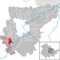 | |
| Coordinates: 50°53′21″N 11°12′14″E / 50.88917°N 11.20389°ECoordinates: 50°53′21″N 11°12′14″E / 50.88917°N 11.20389°E | |
| Country | Germany |
| State | Thuringia |
| District | Weimarer Land |
| Municipal assoc. | Kranichfeld |
| Government | |
| • Mayor | Fred Menge |
| Area | |
| • Total | 10.12 km2 (3.91 sq mi) |
| Elevation | 318 m (1,043 ft) |
| Population (2017-12-31)[1] | |
| • Total | 639 |
| • Density | 63/km2 (160/sq mi) |
| Time zone | CET/CEST (UTC+1/+2) |
| Postal codes | 99438 |
| Dialling codes | 036450 |
| Vehicle registration | AP |
| Website | www.gemeinde-tonndorf.de |
Tonndorf (![]()
References
This article is issued from
Wikipedia.
The text is licensed under Creative Commons - Attribution - Sharealike.
Additional terms may apply for the media files.