Bad Sulza
| Bad Sulza | ||
|---|---|---|
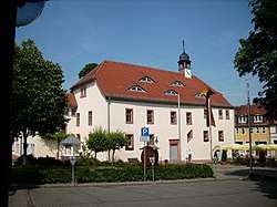 Town hall | ||
| ||
 Bad Sulza Location of Bad Sulza within Weimarer Land district 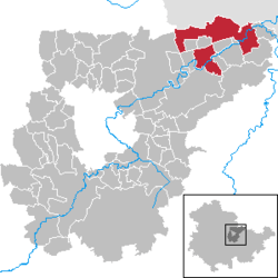 | ||
| Coordinates: 51°5′15″N 11°37′20″E / 51.08750°N 11.62222°ECoordinates: 51°5′15″N 11°37′20″E / 51.08750°N 11.62222°E | ||
| Country | Germany | |
| State | Thuringia | |
| District | Weimarer Land | |
| Government | ||
| • Mayor | Johannes Hertwig (CDU) | |
| Area | ||
| • Total | 46.32 km2 (17.88 sq mi) | |
| Elevation | 140 m (460 ft) | |
| Population (2017-12-31)[1] | ||
| • Total | 4,695 | |
| • Density | 100/km2 (260/sq mi) | |
| Time zone | CET/CEST (UTC+1/+2) | |
| Postal codes | 99518, 99510 (Flurstedt, Gebstedt, Wickerstedt) | |
| Dialling codes | 036461 | |
| Vehicle registration | AP, APD | |
| Website | www.bad-sulza.de | |

Bad Sulza is a town in the Weimarer Land district, in Thuringia, Germany. It is situated on the river Ilm, 15 km southwest of Naumburg, and 18 km north of Jena.
History
Within the German Empire (1871-1918), Bad Sulza was part of the Grand Duchy of Saxe-Weimar-Eisenach.
Notable citizens
- Johann Agricola (1590-1668), superintendent of the salt plant from 1622 to 1631, used the healing power of Sulza brine for therapuetic purposes.
- Adolf Piltz (1855-1940), German mathematician notable for his work in number theory.
Associated with the city
- Thomas Naogeorgus (actually Kirchmair) (1508-1563), theologian, Neo-Latin poet and playwright
Links
![]()
References
| Authority control |
|---|
This article is issued from
Wikipedia.
The text is licensed under Creative Commons - Attribution - Sharealike.
Additional terms may apply for the media files.