Ilmtal-Weinstraße
| Ilmtal-Weinstraße | |
|---|---|
 Ilmtal-Weinstraße Location of Ilmtal-Weinstraße within Weimarer Land district 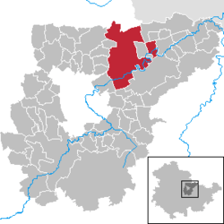 | |
| Coordinates: 51°03′N 11°26′E / 51.050°N 11.433°ECoordinates: 51°03′N 11°26′E / 51.050°N 11.433°E | |
| Country | Germany |
| State | Thuringia |
| District | Weimarer Land |
| Area | |
| • Total | 64.84 km2 (25.03 sq mi) |
| Population (2017-12-31)[1] | |
| • Total | 4,520 |
| • Density | 70/km2 (180/sq mi) |
| Time zone | CET/CEST (UTC+1/+2) |
| Postal codes | 99510 |
| Dialling codes | 036373, 03644, 036462, 036463 |
| Vehicle registration | AP |
| Website | www.vg-ilmtal-weinstrasse.de |
Ilmtal-Weinstraße is a municipality in the district Weimarer Land, in Thuringia, Germany. It was named after the river Ilm, that flows through the municipality. It was formed on 31 December 2013 by the merger of the former municipalities Liebstedt, Mattstedt, Niederreißen, Niederroßla, Nirmsdorf, Oberreißen, Oßmannstedt, Pfiffelbach and Willerstedt. Before, these municipalities had cooperated in the Verwaltungsgemeinschaft ("collective municipality") Ilmtal-Weinstraße, which was disbanded on 1 December 2011. The municipality Kromsdorf, which was part of the Verwaltungsgemeinschaft Ilmtal-Weinstraße, did not join the municipality Ilmtal-Weinstraße. The seat of the municipality and of the former Verwaltungsgemeinschaft is in Pfiffelbach.
Area codes:
- 03644 for Mattstedt, Niederroßla and district Wersdorf of municipality Pfiffelbach
- 036462 for Liebstedt, Oßmannstedt, Pfiffelbach
- 036463 for Nirmsdorf, Willerstedt
- 036373 for Niederreißen and Oberreißen
References
External links
- (in German) Ilmtal-Weinstraße official site
| Authority control |
|---|