Bechstedtstraß
| Bechstedtstraß | |
|---|---|
 | |
 Bechstedtstraß Location of Bechstedtstraß within Weimarer Land district 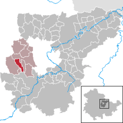 | |
| Coordinates: 50°56′56″N 11°11′46″E / 50.94889°N 11.19611°ECoordinates: 50°56′56″N 11°11′46″E / 50.94889°N 11.19611°E | |
| Country | Germany |
| State | Thuringia |
| District | Weimarer Land |
| Municipal assoc. | Grammetal |
| Government | |
| • Mayor | Lothar Möller |
| Area | |
| • Total | 5.73 km2 (2.21 sq mi) |
| Elevation | 335 m (1,099 ft) |
| Population (2017-12-31)[1] | |
| • Total | 258 |
| • Density | 45/km2 (120/sq mi) |
| Time zone | CET/CEST (UTC+1/+2) |
| Postal codes | 99428 |
| Dialling codes | 03643 |
| Vehicle registration | AP |
| Website |
www.weimar-umland.de /vggrammetal |
Bechstedtstraß is a municipality in the Weimarer Land district of Thuringia, Germany.
References
| Authority control |
|---|
This article is issued from
Wikipedia.
The text is licensed under Creative Commons - Attribution - Sharealike.
Additional terms may apply for the media files.