Schmiedehausen
| Schmiedehausen | ||
|---|---|---|
| ||
 Schmiedehausen Location of Schmiedehausen within Weimarer Land district 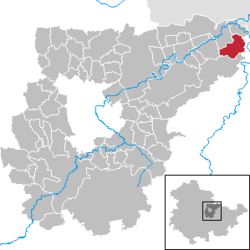 | ||
| Coordinates: 51°4′7″N 11°39′52″E / 51.06861°N 11.66444°ECoordinates: 51°4′7″N 11°39′52″E / 51.06861°N 11.66444°E | ||
| Country | Germany | |
| State | Thuringia | |
| District | Weimarer Land | |
| Municipal assoc. | Bad Sulza | |
| Government | ||
| • Mayor | Bernd Otterstein | |
| Area | ||
| • Total | 10.37 km2 (4.00 sq mi) | |
| Elevation | 225 m (738 ft) | |
| Population (2017-12-31)[1] | ||
| • Total | 373 | |
| • Density | 36/km2 (93/sq mi) | |
| Time zone | CET/CEST (UTC+1/+2) | |
| Postal codes | 99518 | |
| Dialling codes | 036421 | |
| Vehicle registration | AP | |
| Website | www.bad-sulza.de | |

Schmiedehausen is a municipality in the Weimarer Land district of Thuringia, Germany. Schmiedehausen is located in the extreme northeastern corner of the Saale-Ilm-limestone slab and is easily accessible via Camburg and Bad Sulza on the country road in 2158. The district of the town is developed for agricultural purposes. The wooded hills of the Ilm valley start at Bergsulza.
References
This article is issued from
Wikipedia.
The text is licensed under Creative Commons - Attribution - Sharealike.
Additional terms may apply for the media files.