Tong (ward)
| Tong | |
|---|---|
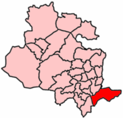 2004 Boundaries of Tong Ward | |
| Population | 20,608 (ward. 2011) |
| UK Parliament | |
| Councillors | |
Tong (population 17,069 - 2001 UK census) is a ward within the City of Bradford Metropolitan District Council, West Yorkshire, England, named after Tong village which is its oldest settlement. The population at the 2011 Census was 20,608.[1]
Geography
The ward is in the extreme southeast of Bradford District in a green wedge of land between the urban areas of Bradford and Leeds, the centre of the former being 3 miles (5 km) to the northwest and the centre of the latter being about 4 miles (6 km) to the northeast. Although surrounded by Green Belt, most of the settlements nearest to Tong are urban in character, Tong Street being 1.5 miles (2.4 km) to the west of the village, Drighlington 1 mile (1.6 km) to the south, Gildersome, 1.5 miles (2.4 km) to the southeast and New Farnley 1.25 miles (2 km) to the east (distances from the boundaries of the ward). The rural village of Bankhouse and the Moravian settlement of Fulneck in Pudsey are about 0.6 miles (1 km) to the north of Tong with Cockersdale 0.6 miles (1 km) to the southeast. East Bierley, immediately adjacent in the south, is part of Kirklees.
History
The ward was formed from the former civil parish of Tong which in the 19th century included the settlements of Dudley Hill, Tong Street, Westgate Hill, and Holme.[2]
The Tong political ward includes the urban areas of Dudley Hill, and the council estates of Bierley, West Yorkshire, Holme Wood, Tyersal. These settlements stretch along the main thoroughfare, Tong Street, which is part of the A650 road. In contrast, Tong Village on Tong Lane is a small, rural village surrounded by farmers' fields, and home to a historic local cricket club, Tong CC.
Coal and ironstone were mined in the area in the 19th and the early 20th centuries, and several mines are recorded.[3][4]
Governance
- Councillors
Tong is represented on Bradford Council by three Labour Party councillors; Alan Wainwright (Lab)[5], Tess Peart (Lab)[6], and Michael Johnson (Lab)[7]
| Election | Councillor | Councillor | Councillor | |||
|---|---|---|---|---|---|---|
| 2004 | James Anthony Cairns (Lab) | John Ruding (Lab) | Michael Johnson (Lab) | |||
| 2006 | James Cairns (Lab) | John Ruding (Lab) | Michael Johnson (Lab) | |||
| 2007 | James Cairns (Lab) | John Ruding (Lab) | Michael Johnson (Lab) | |||
| 2008 | James Cairns (Lab) | John Ruding (Lab) | Michael Johnson (Lab) | |||
| 2010 | Alan Frederick Wainwright (Lab) | John Ruding (Lab) | Michael Johnson (Lab) | |||
| 2011 | Alan Wainwright (Lab) | John Ruding (Lab) | Michael Johnson (Lab) | |||
| 2012 | Alan Wainwright (Lab) | John Ruding (Lab) | Michael Johnson (Lab) | |||
| 2014 | Alan Wainwright (Lab) | John Ruding (Lab) | Michael Johnson (Lab) | |||
| 2015 | Alan Wainwright (Lab) | Tess Peart (Lab) | Michael Johnson (Lab) | |||
| 2016 | Alan Wainwright (Lab) | Tess Peart (Lab) | Michael Johnson (Lab) | |||
indicates seat up for re-election.
References
- ↑ "City of Bradford ward population 2011". Neighbourhood Statistics. Office for National Statistics. Retrieved 22 February 2016.
- ↑ "Boundary Map of Tong Ch/CP". A Vision of Britain in Time. Retrieved 11 July 2017.
- ↑ Mines of Coal and other Stratified Minerals in Yorkshire from 1854. Retrieved 10 July 2017.
- ↑ Frank N. Wardell. "(The East and West Ridings of) Yorkshire's Mining Industry in 1896 - A List of Coal Mines" (PDF). Peak District Mines Historical Society Ltd.
- ↑ "Councillor Alan Wainwright". bradford.moderngov.co.uk. City of Bradford Metropolitan District Council. Retrieved 27 September 2017.
- ↑ "Councillor Tess Peart". bradford.moderngov.co.uk. City of Bradford Metropolitan District Council. Retrieved 27 September 2017.
- ↑ "Councillor Michael Johnson". bradford.moderngov.co.uk. City of Bradford Metropolitan District Council. Retrieved 27 September 2017.
External links
| Wikimedia Commons has media related to Tong. |
- Council ward profile (PDF)
- Tong at Curlie (based on DMOZ).