Yorkshire Dales


The Yorkshire Dales is an upland area of the Pennines in Northern England in the historic county of Yorkshire, most of it in the Yorkshire Dales National Park created in 1954.[1]
The Dales comprises river valleys and the hills, rising from the Vale of York westwards to the hilltops of the Pennine watershed. In Ribblesdale, Dentdale and Garsdale, the area extends westwards across the watershed, but most of the valleys drain eastwards to the Vale of York, into the Ouse and the Humber. The extensive limestone cave systems are a major area for caving in the UK.
Etymology
The word dale, like dell, is derived from the Old English word dæl. It has cognates in the Nordic/Germanic words for valley (dal, tal), and occurs in valley names across Yorkshire and Northern England.[2] Usage here may have been reinforced by Nordic languages during the time of the Danelaw.[3]
Most of the dales are named after their river or stream (e.g., Arkengarthdale, formed by Arkle Beck). The best-known exception is Wensleydale, which is named after the small village and former market town of Wensley, rather than the River Ure, although an older name for the dale is Yoredale.[4] River valleys all over Yorkshire are called "(name of river)+dale"—but only the more northern valleys (and only the upper, rural, reaches) are included in the term "The Dales".[5]
Geography
The Yorkshire Dales spread to the north from the market and spa towns of Settle, Skipton, Ilkley and Harrogate in North Yorkshire, to the southern boundary in Wharfedale and Airedale. Natural England define the area as mots of the Yorkshire Dales National Park with fringes of the Nidderdale AONB, but without the towns listed above apart from Settle.[6] The lower reaches of Airedale and Wharfedale are not usually included in the area, and Calderdale, south of Airedale , is not often considered part of the Dales even though it is a dale, is in Yorkshire, and its upper reaches are as scenic and rural as many further north.[7]
Most of the larger southern dales, Ribblesdale, Malhamdale and Airedale, Wharfedale and Nidderdale, run roughly parallel from north to south. The more northerly dales, Wensleydale and Swaledale run generally from west to east.[8] There are many other smaller or lesser known dales such as Arkengarthdale, Bishopdale, Clapdale, Coverdale, Kingsdale, Littondale, Langstrothdale, Raydale, Waldendale and the Washburn Valley whose tributary streams and rivers feed into the larger valleys, and Barbondale, Dentdale, Deepdale and Garsdale which feed west to the River Lune.[9]
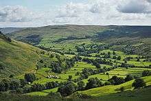
The characteristic scenery of the Dales is green upland pastures separated by dry-stone walls and grazed by sheep and cattle.[10] Many upland areas consist of heather moorland, used for grouse shooting from 12 August (the Glorious Twelfth).[11]
Cultural aspects
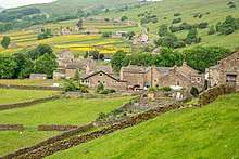
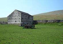
Much of the rural area is used for agriculture, with residents living in small villages and hamlets or in farmsteads. Miles of dry stone walls and much of the traditional architecture has remained,[12] including some field barns, though many are no longer in active use. Breeding of sheep and rearing of cattle remains common.[13] To supplement their incomes, many farmers have diversified, with some providing accommodations for tourists.[14] A number of agricultural shows are held each year.[15]
Lead mining was common in some areas of the Dales in the 19th century, particularly during 1821 to 1861, and some industrial remains can still be found, such as the Grassington miners’ cottages.[16] Certain former mining sites are maintained by Historic England. The Grassington Moor Lead Mining Trail, with its many remaining structures,[17] has received funding from a variety of sources. The National Parks Service provides an app for those who wish to explore the relevant areas.[18]
Tourism
In this primarily agricultural area, tourism has become an important contributor to the economy.[19] In 2016, there were 3.8 million visits to the Yorkshire Dales National Park including 0.48 million who stayed at least one night. The parks service estimates that this contributed £252 million to the economy and provided 3,583 full time equivalent jobs. The wider Yorkshire Dales area received 9.7 million visitors who contributed £644 million to the economy.[20]
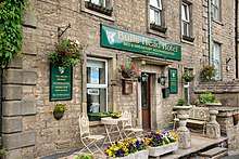
Visitors are often attracted by the hiking trails,[21] including some that lead to beautiful waterfalls[22] and by the picturesque villages. The latter include Kirkby Lonsdale, Hawes, Appletreewick, Masham, Clapham, Long Preston and Malham.[23]
Geology
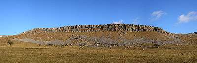
The dales are 'U' and 'V' shaped valleys, the former enlarged and shaped by glaciers, mainly in the most recent Devensian ice age.[24] The underlying rock is mainly Carboniferous Limestone, which results in a large areas of karst topography,[6] in places overlain with shale and sandstone and topped with Millstone Grit,[25] although to the north and west of the Dent Fault[26] the hills are formed from older Silurian and Ordovician rocks.[27][28]
Cave systems
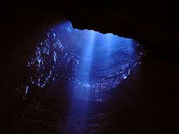
The underlying limestone in parts of the Dales has extensive cave systems, including the 87-kilometre (54-mile) long Three Counties System, making it a major area for caving in the UK. Some caves are open to the public for tours.[29]
The systems include:
See also
References
- ↑ "Yorkshire Dales Area". Yorkshire.com. Retrieved 25 April 2013.
- ↑ Ekwall, Eilert (1960). The concise Oxford dictionary of English place-names (4 ed.). Oxford: Clarendon Press. p. 138. ISBN 0-19-869103-3.
- ↑ Booth, Michael (2015). "Introduction". The Almost Nearly Perfect People (1 ed.). London: Vintage Books. p. 9. ISBN 9780099546078.
- ↑ Rhea, Nicholas (5 November 2010). "Why call it Wensleydale?". Darlington and Stockton Times. Retrieved 10 April 2018.
- ↑ "Yorkshire Dales guide - where, how and what". www.yorkshiredales.net. Retrieved 10 April 2018.
- 1 2 NE 21 2013, p. 3.
- ↑ "The Dales - Yorkshire Dales". yorkshiredales.co.uk. Retrieved 10 April 2018.
- ↑ NE 21 2013, p. 25.
- ↑ Chrystal, Paul (2017). The Place Names of Yorkshire; Cities, Towns, Villages, Rivers and Dales, some Pubs too, in Praise of Yorkshire Ales (1 ed.). Catrine: Stenlake. pp. 102&ndash, 104. ISBN 9781840337532.
- ↑ "Managing the environment | Conflicts of land use | Limestone landscapes | Geology of Britain | British Geological Survey (BGS)". www.bgs.ac.uk. Retrieved 10 April 2018.
- ↑ "Warning volleys fired as war of words erupts over grouse shoot". The Yorkshire Post. 12 August 2017. Retrieved 10 April 2018.
- ↑ "Yorkshire Dales, Northern England - landscape and history". Yorkshire Net. Retrieved 14 July 2018.
- ↑ "Yorkshire Dales National Park - Special qualities of the Yorkshire Dales National Park". Yorkshire Dales National Park Authority. Retrieved 14 July 2018.
- ↑ "Higher Geography - Yorkshire Dales - agriculture". BBC Bitesize. Retrieved 14 July 2018.
- ↑ "Yorkshire Agricultural Shows Guide". Yorkshire Net. Retrieved 14 July 2018.
- ↑ Wainwright, Martin (4 August 2010). "Historic Yorkshire Dales lead mine site to be preserved". The Guardian. Retrieved 14 July 2018.
- ↑ "A walk from The Devonshire, Grassington" (PDF). Wharfedale wander. Retrieved 14 July 2018.
- ↑ "New app helps lead mining come to life in National Park". Yorkshire Dales National Park Authority. Retrieved 14 July 2018.
- ↑ "Economy". Yorkshire Dales National Park Authority. Retrieved 14 July 2018.
- ↑ "Trends in tourism in the Yorkshire Dales 2010 to 2016" (PDF). Retrieved 14 July 2018.
- ↑ Lavelle, Emma. "The Best Hikes to Take in the Yorkshire Dales". Retrieved 14 July 2018.
- ↑ Lavelle, Emma. "Seven Dramatic Waterfalls You Have to See in the Yorkshire Dales". Retrieved 14 July 2018.
- ↑ Lavelle, Emma. "The Most Beautiful Villages in England's Yorkshire Dales". Retrieved 14 July 2018.
- ↑ Ashbourn, Julian (2011). Geological landscapes of Britain (1 ed.). Dordrecht: Springer. p. 143. ISBN 978-90-481-8860-4.
- ↑ NE 21 2013, p. 6.
- ↑ Underhill, J. R.; Gayer, R. A.; Woodcock, N. H.; Donnelly, R.; Jolley, E. J.; Stimpson, I. G. (1 April 1988). "The Dent Fault System, northern England—reinterpreted as a major oblique-slip fault zone". lyellcollection.org. Journal of the Geological Society. pp. 303–316. doi:10.1144/gsjgs.145.2.0303. Retrieved 10 April 2018.
- ↑ "Out of Oblivion: A landscape through time". www.outofoblivion.org.uk. Retrieved 10 April 2018.
- ↑ "Gorges | Topographical features created by erosion | Limestone topography | Limestone landscapes | Geology of Britain | British Geological Survey (BGS)". www.bgs.ac.uk. Retrieved 10 April 2018.
- ↑ "Caves and Caving in the Yorkshire Dales". Archived from the original on 6 September 2011.
- ↑ Krol, Charlotte (26 May 2015). "Yorkshire cave twice the height of Niagara Falls open to public for abseiling". The Telegraph. Retrieved 10 April 2018.
- ↑ Ward, David (29 December 2007). "Man and woman found drowned in flooded cave". The Guardian. Retrieved 10 April 2018.
- ↑ "What lies beneath: Mossdale caving disaster". The Independent. 15 March 2008. Retrieved 10 April 2018.
- ↑ Holmes, Matthew (4 August 2016). "Your pictures of the newly enlarged Yorkshire Dales and Lake District". The Guardian. Retrieved 10 April 2018.
- ↑ "Three Counties system". yorkshiredales.org.uk. Retrieved 10 April 2018.
- ↑ "White Scar Caves". Archived from the original on 19 October 2008.
- ↑ "Welcome to Ingleborough Cave". Ingleboroughcave.co.uk. Retrieved 31 January 2018.
- ↑ "Stump Cross Caverns". Stumpcrosscaverns.co.uk. Retrieved 31 January 2018.
- ↑ Dooks, Brian (16 November 2005). "Tranquillity returns to site that claimed a young boy's life". The Yorkshire Post. Retrieved 10 April 2018.
Sources
- NCA Profile: 21. Yorkshire Dales (NE399) (PDF) (Report). Natural England. 13 January 2013. Retrieved 10 April 2018.
External links
| Wikimedia Commons has media related to Yorkshire Dales. |
| Wikivoyage has a travel guide for Yorkshire Dales. |