Tofino
| Tofino | |
|---|---|
| District municipality | |
| District of Tofino[1] | |
|
View toward Meares Island | |
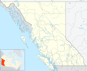
 Tofino Location of Tofino in British Columbia | |
| Coordinates: 49°08′38″N 125°53′30″W / 49.14389°N 125.89167°W | |
| Country |
|
| Province |
|
| Regional District | Alberni-Clayoquot |
| Incorporated | 1932 |
| Government | |
| • Mayor | Josie Osborne |
| Area | |
| • Total | 10.53 km2 (4.07 sq mi) |
| Elevation | 10 m (30 ft) |
| Population (2016) | |
| • Total | 1,932 |
| • Density | 183.1/km2 (474/sq mi) |
| Time zone | UTC−8 (PST) |
| • Summer (DST) | UTC−7 (PDT) |
| Postal code span | V0R 2Z0 |
| Area code(s) | 250 |
| Climate | Cfb |
| Website |
tofino |
Tofino is a district of approximately 1,932 residents on the west coast of Vancouver Island in the Canadian province of British Columbia. The district is located at the western terminus of Highway 4 on the tip of the Esowista Peninsula at the southern edge of Clayoquot Sound.
A popular tourist destination in the summer, Tofino's population swells to many times its winter size. It attracts surfers, hikers, nature lovers, bird watchers, campers, whale watchers, fishers, or anyone just looking to be close to nature. In the winter it is not as bustling, although many people visit Tofino and the west coast to watch storms on the water. Close to Tofino is Long Beach, a scenic and popular year-round destination, at the Pacific Rim National Park Reserve. With its natural hot springs, Maquinna Marine Provincial Park[2] is a popular day-trip destination for tourists. Reachable by boat or float plane, the park is located about 45 kilometres (28 mi) north of Tofino.
Etymology
The settlement acquired its name in 1909 with the opening of the Tofino Post Office, named after the nearby Tofino Inlet.[3] This geographical feature had been named in 1792 by the Spanish explorers Galiano and Valdés, in honour of Admiral Vicente Tofiño de San Miguel y Wanderiales (or Vanderiales), under whom Galiano had learned cartography.[4]
Transportation
Tofino Airport, 11 km south of the town, is accessible to private and commercial aircraft. Floatplanes land on the inlet in town. Coastal fog is a common morning phenomenon in the summer, complicating access by air until the weather clears.
Tofino is located at the western end of Highway 4 that connects the community with Port Alberni and the population centres on the east coast of Vancouver Island. There are no roads connecting Tofino along the west coast of Vancouver Island except to the nearby community of Ucluelet.
Boat services connect Tofino with coastal communities such as Ahousat and Hot Springs Cove. Wildlife-watching tour boats operate in the area. In October 2015, a whale watching vessel capsized off the coast of Tofino resulting the deaths of 6 passengers.
Festivities and events
Every March, the migration of thousands of grey whales is celebrated with the Pacific Rim Whale Festival. The last weekend of April is the Tofino Shorebird Festival. The first week-end of June brings the Tofino Food and Wine Festival, featuring British Columbia wines and showcasing the creations of Tofino chefs. The end of August brings the Tofino Lantern Festival (voted Tofino's most popular event by Tofino Time Magazine), early September has the week long Race for The Blue Tuna Shoot-Out[5] from September 7th – 15th, and mid-September brings "Art in the Gardens," a two-day arts and music festival. The O'Neill Coldwater Surf Classic was held 25–31 October, the first professional ASP surf event ever held in Canada. In November is the Clayoquot Oyster Festival, as well as the Queen of the Peak all-female surf competition.[6] Rip Curl Pro Tofino, the official Canadian surfing championship, has been held each year in May, since 2007.[7]
Climate
Due to Tofino's mild winters yet cool summers, the location is the very definition of temperate. Tofino's winters are mild enough that it can grow palm trees. Summers are the driest season with 76.8 mm of rain in July - still more than most other locations in BC for that month.[8] During the cooler season, however, there is a lot of precipitation, with 492.1 mm in November alone. Nearly all of the precipitation that falls throughout the course of a year is rain, with 203 days with rain and only 7.8 days with snowfall. Due to its location on the westernmost part of Vancouver Island, Tofino faces the Pacific Ocean, unimpeded by any mountains to the west (and therefore not subject to a rain shadow effect like much of the eastern island and the BC interior). Winter cyclonic storms frequently pass over the town deluging it with rain, making it one of the wettest locations in Canada. The month of November alone brings more precipitation to Tofino than that received for more than an entire year in parts of the BC interior such as Kamloops and Penticton.[8] Like the rest of BC, summer brings relative dryness; even so, it still receives much more summertime precipitation than the interior or even the coast (which can often be susceptible to drought-like conditions until the onset of autumn).[8]
The highest temperature ever recorded in Tofino was 33.9 °C (93 °F) on 15 July 1941.[9] The coldest temperature ever recorded was −15.0 °C (5 °F) on 30 January 1969.[10]
| Climate data for Tofino Airport, 1981–2010 normals, extremes 1896–present[lower-alpha 1] | |||||||||||||
|---|---|---|---|---|---|---|---|---|---|---|---|---|---|
| Month | Jan | Feb | Mar | Apr | May | Jun | Jul | Aug | Sep | Oct | Nov | Dec | Year |
| Record high °C (°F) | 20.1 (68.2) |
19.4 (66.9) |
19.4 (66.9) |
24.4 (75.9) |
29.4 (84.9) |
32.2 (90) |
33.9 (93) |
32.8 (91) |
29.4 (84.9) |
25.6 (78.1) |
21.1 (70) |
19.4 (66.9) |
33.9 (93) |
| Average high °C (°F) | 8.3 (46.9) |
9.0 (48.2) |
10.1 (50.2) |
11.9 (53.4) |
14.5 (58.1) |
16.8 (62.2) |
18.9 (66) |
19.1 (66.4) |
17.8 (64) |
13.6 (56.5) |
10.0 (50) |
8.1 (46.6) |
13.2 (55.8) |
| Daily mean °C (°F) | 5.3 (41.5) |
5.4 (41.7) |
6.5 (43.7) |
8.0 (46.4) |
10.5 (50.9) |
12.9 (55.2) |
14.7 (58.5) |
15.0 (59) |
13.4 (56.1) |
10.0 (50) |
6.8 (44.2) |
5.0 (41) |
9.5 (49.1) |
| Average low °C (°F) | 2.3 (36.1) |
1.9 (35.4) |
2.7 (36.9) |
4.0 (39.2) |
6.5 (43.7) |
8.9 (48) |
10.5 (50.9) |
10.8 (51.4) |
9.0 (48.2) |
6.3 (43.3) |
3.6 (38.5) |
1.9 (35.4) |
5.7 (42.3) |
| Record low °C (°F) | −15.0 (5) |
−11.1 (12) |
−6.1 (21) |
−3.3 (26.1) |
−1.1 (30) |
1.1 (34) |
3.3 (37.9) |
3.3 (37.9) |
−0.6 (30.9) |
−3.5 (25.7) |
−12.7 (9.1) |
−12.2 (10) |
−15.0 (5) |
| Average precipitation mm (inches) | 486.6 (19.157) |
336.1 (13.232) |
329.8 (12.984) |
269.9 (10.626) |
153.0 (6.024) |
129.7 (5.106) |
71.0 (2.795) |
88.1 (3.469) |
132.8 (5.228) |
341.9 (13.461) |
492.1 (19.374) |
440.0 (17.323) |
3,270.7 (128.768) |
| Average rainfall mm (inches) | 477.4 (18.795) |
327.3 (12.886) |
325.7 (12.823) |
269.2 (10.598) |
153.0 (6.024) |
129.7 (5.106) |
71.0 (2.795) |
88.1 (3.469) |
132.8 (5.228) |
341.8 (13.457) |
489.4 (19.268) |
432.0 (17.008) |
3,237.2 (127.449) |
| Average snowfall cm (inches) | 9.2 (3.62) |
8.7 (3.43) |
4.0 (1.57) |
0.7 (0.28) |
0 (0) |
0 (0) |
0 (0) |
0 (0) |
0 (0) |
0.1 (0.04) |
2.8 (1.1) |
7.9 (3.11) |
33.3 (13.11) |
| Average precipitation days (≥ 0.2 mm) | 22.7 | 18.7 | 21.7 | 18.4 | 15.7 | 13.8 | 10.0 | 10.9 | 11.7 | 19.4 | 22.9 | 21.9 | 207.8 |
| Average rainy days (≥ 0.2 mm) | 22.1 | 18.4 | 21.5 | 18.4 | 15.7 | 13.8 | 10.0 | 10.9 | 11.7 | 19.4 | 22.6 | 21.6 | 205.9 |
| Average snowy days (≥ 0.2 cm) | 1.9 | 1.5 | 1.3 | 0.4 | 0 | 0 | 0 | 0 | 0 | 0 | 0.9 | 2.0 | 7.8 |
| Average relative humidity (%) | 83.6 | 76.7 | 75.6 | 73.2 | 71.3 | 71.7 | 71.7 | 74.8 | 73.2 | 79.3 | 82.9 | 84.6 | 76.5 |
| Mean monthly sunshine hours | 58.6 | 81.6 | 126.3 | 170.3 | 203.1 | 190.9 | 226.7 | 199.6 | 175.8 | 116.1 | 62.5 | 56.5 | 1,668.1 |
| Percent possible sunshine | 21.7 | 28.5 | 34.3 | 41.5 | 42.9 | 39.4 | 46.4 | 44.8 | 46.4 | 34.6 | 22.7 | 22.0 | 35.4 |
| Source: Environment Canada[10][11] | |||||||||||||

Telecommunications
Tofino has modern cell phone and land line access (including Internet and ADSL).
Media
Tofino has one newspaper, the Tofino-Ucluelet Westerly News. Radio stations heard in Tofino are CHMZ-FM on 90.1 FM, and CBC Radio One on 91.5 FM.
Health and education
Public education is offered by the School District 70 Alberni, through the Wickaninnish Community School in Tofino and Ucluelet Secondary School in Ucluelet. The town's hospital is the Tofino General Hospital, operated by the Vancouver Island Health Authority (VIHA).[12]
Cultural references

Music
- Montreal third wave ska band The Planet Smashers recorded a song on their album Life of the Party entitled "Surfin' in Tofino".[13]
- The punk band Gob filmed their music video "No Regrets", directed by William Morrison, on Long Beach.
- Canadian band Prairie Dance Club recorded a song entitled "Tofino".[14]
Film and television
- Tofino was a filming location for the film The Twilight Saga: New Moon in March and April 2009. South Beach, located near Wickaninnish Beach inside Pacific Rim National Park Reserve, and Incinerator Rock at Long Beach were used.[15]
References
- ↑ "British Columbia Regional Districts, Municipalities, Corporate Name, Date of Incorporation and Postal Address" (XLS). British Columbia Ministry of Communities, Sport and Cultural Development. Retrieved 2 November 2014.
- ↑ "redirect". Retrieved 7 April 2016.
- ↑ "Tofino". BC Geographical Names.
- ↑ Dionisio Alcalá Galiano: The Canadian Adventure of a Spanish Naval Hero, Malaspina University-College
- ↑ "Blue Tuna Shoot-Out". Tofino Resort + Marina. Retrieved September 16, 2018.
- ↑ "Storm watching is catching on". Toronto Star, November 5, 2016, page T1, Emma Yardley.
- ↑ "Rip Curl Pro Tofino - Announces Dates for 2017". Rip Curl. Retrieved 16 May 2017.
- 1 2 3 "Canadian Climate Normals 1971-2000". Environment Canada. Retrieved 16 February 2011.
- ↑ "Daily Data Report for July 1941". Environment Canada. Retrieved 3 March 2017.
- 1 2 "Calculation Information for 1981 to 2010 Canadian Normals Data". Environment Canada. Retrieved 3 March 2017.
- ↑ "Clayoquot". Environment Canada. Retrieved 3 March 2017.
- ↑ Tofino General Hospital. Retrieved 2011-10-24
- ↑ Steve Huey. "The Life of the Party". AllMusic. Retrieved 7 April 2016.
- ↑ "Prairie Dance Club - Prairie Dance Club | Songs, Reviews, Credits | AllMusic". AllMusic. Retrieved 2018-09-30.
- ↑ "Tofino provides perfect setting for Twilight's vampires". The Globe and Mail. Retrieved 7 April 2016.
External links

| Wikivoyage has a travel guide for Tofino. |
Coordinates: 49°08′38″N 125°53′30″W / 49.14389°N 125.89167°W
