British Columbia Highway 4
| ||||
|---|---|---|---|---|
|
Alberni Highway Pacific Rim Highway | ||||
| Route information | ||||
| Length | 162 km[1] (101 mi) | |||
| Major junctions | ||||
| East end |
| |||
|
| ||||
| West end | Government Wharf in Tofino | |||
| Location | ||||
| Districts | Tofino | |||
| Major cities | Port Alberni | |||
| Towns | Qualicum Beach | |||
| Highway system | ||||
|
British Columbia provincial highways
| ||||

Highway 4 is the longest east-west main vehicle route on Vancouver Island, British Columbia, Canada, with a total length of 162 km (100 mi). It known locally as the Alberni Highway to the east of Port Alberni and the Pacific Rim Highway to the west. The original highway from Parksville to Alberni and Port Alberni was completed in 1942 and was originally designated as Highway 1A. It was re-designated as Highway 4 in 1953, and was extended in 1961 to the small community of Tofino, on the west coast of the Island.
Route details
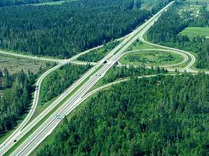
Highway 4's eastern terminus is at the interchange with Highway 19 at in Qualicum Beach; however, the roadway continues north as Memorial Avenue for 4 km (2 mi) to Highway 19A. From Highway 19, it travels south for 3 km (2 mi) to a junction with an older Alberni Highway segment, now known as Highway 4A, at the small community of Hilliers in Coombs. Highway 4 veers directly west upon meeting this junction.
The majority of Highway 4's length is composed of a two-lane configuration. An abandoned spur of the E&N Railway parallels Highway 4 all the way from the coast to the city of Port Alberni.
West of Coombs Junction, Highway 4 travels for 11 km (7 mi) before meeting Cameron Lake. Highway 4 hugs the shore of Cameron Lake for 5 km (3 mi), then winds its way through MacMillan Provincial Park, which includes a tourist attraction known as Cathedral Grove. After Cameron Lake, Highway 4 climbs for 8 km (5 mi), following the Cameron River, to the Port Alberni Summit—the highest point on the highway (elevation: 411 metres (1,348 ft)), known by locals as "The Hump", at which it crosses from the Regional District of Nanaimo into the Alberni-Clayoquot Regional District—and then descends for 6 km (4 mi) to a spur that travels into the city centre of Port Alberni. Highway 4 actually enters the city limits of Port Alberni 2 km (1.2 mi) west of the main spur into the city, and 5 km (3 mi) later, exits Port Alberni via a bridge over the Somass River.
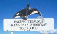
6 km (4 mi) west of the Somass River crossing, Highway 4 reaches the shore of Sproat Lake, following the lake shore west for 24 km (15 mi). Highway 4 then follows the Taylor River for 10 km (6 mi) to the summit of Sutton Pass (elevation: 240 metres (790 ft)), named after William John Sutton, and then turns toward the south-southwest to follow the Kennedy River. This very winding bearing of Highway 4, which features very steep grades, continues for 23 km (14 mi) before reaching the southeast shore of Kennedy Lake. Highway 4 then follows the shore of Kennedy Lake southwest for 19 km (12 mi), then reaches a junction with a spur into the settlement of Ucluelet 5 km (3 mi) later. At the Tofino-Ucluelet junction, known locally as "The Junction," Highway 4 then makes a ninety-degree turn towards the northwest. 1 km (0.6 mi) later, Highway 4 enters the Long Beach Unit of Pacific Rim National Park Reserve. Highway 4 goes through the national park for 22 km (14 mi) northwest, finally terminating 11 km (7 mi) later at Tofino.
Major intersections
From east to west:
| Regional district | Location | km[1] | mi | Destinations | Notes |
|---|---|---|---|---|---|
| Nanaimo | Qualicum Beach | −3.70 | −2.30 | ||
| 0.00 | 0.00 | Hilliers Interchange (Hwy 19 Exit 60) Hwy 4 eastern terminus | |||
| | 2.62 | 1.63 | |||
| Alberni-Clayoquot | Port Alberni | 37.74 | 23.45 | Gertrude Street – City Centre | |
| | 128.72 | 79.98 | Ucluelet Road (Hwy 963:2386 south) – Ucluelet | Hwy 963:2386 is unsigned | |
| 131.14– 151.43 | 81.49– 94.09 | Passes through Pacific Rim National Park Reserve | |||
| Tofino | 161.60 | 100.41 | Government Warf | Hwy 4 western terminus | |
1.000 mi = 1.609 km; 1.000 km = 0.621 mi
| |||||
Highway 4A
| |
|---|---|
| Location | Coombs–Parksville |
| Length | 9.7 km[1] (6.0 mi) |
Highway 4A is the previous alignment of Highway 4 east of Coombs. The '4A' designation was originally assigned in 1968 to the current section of Highway 4 between Coombs and Qualicum Beach. The 4 and 4A alignments east and north of Coombs, respectively, switched designations when the Parksville to Mud Bay section of the Inland Island Highway was completed in 1996. This older spur of Highway 4 terminates in the east at Parksville, 10 kilometres (6.2 mi) from Coombs.
Major intersections
| Regional district | Location | km[1] | mi | Destinations | Notes |
|---|---|---|---|---|---|
| Nanaimo | Parksville | −1.90 | −1.18 | ||
| 0.00 | 0.00 | Allsbrook Interchange (Hwy 19 Exit 51) Hwy 4A eastern terminus | |||
| Coombs | 6.83 | 4.24 | Station Road | ||
| | 9.67 | 6.01 | Hwy 4A western terminus | ||
1.000 mi = 1.609 km; 1.000 km = 0.621 mi
| |||||
External links
- Official Numbered Routes in British Columbia by British Columbia Driving & Transportation
References
- 1 2 3 4 Landmark Kilometre Inventory (PDF). British Columbia Ministry of Transportation and Infrastructure (Report). Cypher Consulting. July 2016. pp. 131–139.