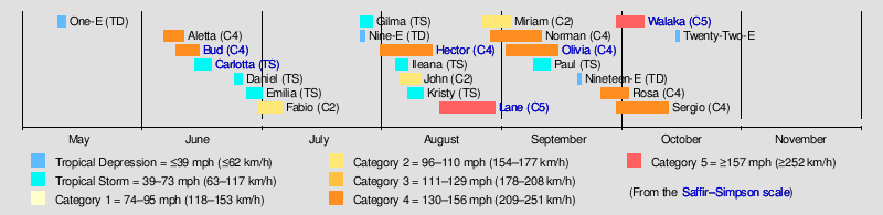
Timeline of the 2018 Pacific hurricane season
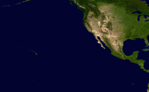
The 2018 Pacific hurricane season is a current event in the annual cycle of tropical cyclone formation, in which tropical cyclones form in the eastern Pacific Ocean. The season officially started on May 15 in the eastern Pacific—east of 140°W—and will begin on June 1 in the central Pacific—between the International Date Line and 140°W, and will end on November 30. These dates typically cover the period of each year when most tropical cyclones form in the eastern Pacific basin.[1]
Four time zones are utilized in the basin: Central for storms east of 106°W, Mountain between 114.9°W and 106°W, Pacific between 140°W and 115°W,[2] and Hawaii–Aleutian for storms between the International Date Line and 140°W. However, for convenience, all information is listed by Coordinated Universal Time (UTC) first with the respective local time included in parentheses. This timeline includes information that was not operationally released, meaning that data from post-storm reviews by the National Hurricane Center is included. This timeline documents tropical cyclone formations, strengthening, weakening, landfalls, extratropical transitions, and dissipations during the season.
Timeline of events
May
May 10
- 21:00 UTC (2:00 p.m. PDT) at 12°24′N 126°30′W / 12.4°N 126.5°W – Tropical Depression One-E develops from an area of disturbed weather 1310 miles (2105 km) west-southwest of the southern tip of the Baja California Peninsula.[3]
May 11
- 03:00 UTC (8:00 p.m. PDT May 10) at 12°42′N 127°24′W / 12.7°N 127.4°W – Tropical Depression One-E reaches peak intensity with maximum sustained winds of 35 mph (55 km/h) and a minimum pressure of 1006 mbar (hPa; 29.71 inHg), located 1345 miles (2170 km) west-southwest of the southern tip of the Baja California Peninsula.[4]
May 12
- 03:00 UTC (8:00 p.m. PDT May 11) at 12°54′N 130°12′W / 12.9°N 130.2°W – Tropical Depression One-E degenerates to a post-tropical cyclone 1500 miles (2415 km) west-southwest of the southern tip of the Baja California Peninsula.[5]
May 15
- The 2018 Eastern Pacific hurricane season officially begins.[1]
June
June 1
- The 2018 Central Pacific hurricane season officially begins.[1]
June 6
- 03:00 UTC (10:00 p.m. CDT June 5) at 14°06′N 105°42′W / 14.1°N 105.7°W – Tropical Depression Two-E develops from an area of low pressure about 350 miles (565 km) south-southwest of Manzanillo, Colima.[6]
- 09:00 UTC (3:00 a.m. MDT) at 14°06′N 106°30′W / 14.1°N 106.5°W – Tropical Depression Two-E intensifies into Tropical Storm Aletta about 370 miles (595 km) south-southwest of Manzanillo.[7]
June 7
- 21:00 UTC (3:00 p.m. MDT) at 15°18′N 110°00′W / 15.3°N 110.0°W – Tropical Storm Aletta intensifies into a Category 1 hurricane roughly 455 miles (730 km) west-southwest of Manzanillo, Colima.[8]
June 8
- 03:00 UTC (9:00 p.m. MDT June 7) at 15°36′N 110°18′W / 15.6°N 110.3°W – Hurricane Aletta intensifies into a Category 2 hurricane approximately 460 miles (740 km) west-southwest of Manzanillo, Colima.[9]
- 06:00 UTC (12:00 a.m. MDT) at 15°36′N 110°30′W / 15.6°N 110.5°W – Hurricane Aletta intensifies into a Category 3 hurricane approximately 470 miles (760 km) west-southwest of Manzanillo, Colima.[10]
- 15:00 UTC (9:00 a.m. MDT) at 15°48′N 111°12′W / 15.8°N 111.2°W – Hurricane Aletta intensifies into a Category 4 hurricane roughly 505 miles (815 km) west-southwest of Manzanillo, Colima.[11]
June 9
- 03:00 UTC (9:00 p.m. MDT June 8) at 16°12′N 112°18′W / 16.2°N 112.3°W – Hurricane Aletta weakens into a Category 3 hurricane about 200 miles (320 km) south-southwest of Socorro Island.[12]
- 09:00 UTC (3:00 a.m. MDT) at 16°12′N 112°42′W / 16.2°N 112.7°W – Hurricane Aletta weakens into a Category 2 hurricane about 210 miles (340 km) south-southwest of Socorro Island.[13]
- 21:00 UTC (3:00 p.m. MDT) at 16°06′N 113°54′W / 16.1°N 113.9°W – Hurricane Aletta weakens into a Category 1 hurricane about 265 miles (340 km) south-southwest of Socorro Island.[14]
- 21:00 UTC (4:00 p.m. CDT) at 12°24′N 101°36′W / 12.4°N 101.6°W – Tropical Depression Three-E develops from an area of low pressure about 365 miles (590 km) south of Zihuatanejo, Mexico.[15]
June 10
- 03:00 UTC (9:00 p.m. MDT June 9) at 15°54′N 114°18′W / 15.9°N 114.3°W – Hurricane Aletta weakens into a tropical storm about 560 miles (905 km) south-southwest of the southern tip of Baja California.[16]
- 03:00 UTC (10:00 p.m. CDT June 9) at 12°54′N 102°00′W / 12.9°N 102.0°W – Tropical Depression Three-E intensifies into Tropical Storm Bud about 330 miles (535 km) south of Zihuatanejo, Mexico.[17]
- 21:00 UTC (4:00 p.m. CDT) at 15°18′N 104°12′W / 15.3°N 104.2°W – Tropical Storm Bud intensifies into a Category 1 hurricane about 255 miles (410 km) south of Manzanillo, Mexico.[18]
June 11
- 09:00 UTC (3:00 a.m. MDT) at 16°18′N 106°06′W / 16.3°N 106.1°W – Hurricane Bud intensifies into a Category 2 hurricane about 220 miles (355 km) south-southwest of Manzanillo, Mexico.[19]
- 15:00 UTC (8:00 a.m. PDT) at 16°48′N 117°48′W / 16.8°N 117.8°W – Tropical Storm Aletta weakens into a tropical depression about 665 miles (1070 km) southwest of the southern tip of Baja California.[20]
- 15:00 UTC (9:00 a.m. MDT) at 16°42′N 106°48′W / 16.7°N 106.8°W – Hurricane Bud intensifies into a Category 3 hurricane about 265 miles (425 km) south-southwest of Cabo Corrientes, Mexico.[21]
- 21:00 UTC (2:00 p.m. PDT) at 16°36′N 118°18′W / 16.6°N 118.3°W – Tropical Depression Aletta degenerates to a post-tropical cyclone about 700 miles (1125 km) southwest of the southern tip of Baja California.[22]
June 12
- 09:00 UTC (3:00 a.m. MDT) at 18°06′N 108°12′W / 18.1°N 108.2°W – Hurricane Bud intensifies into a Category 4 hurricane about 230 miles (365 km) southwest of Cabo Corrientes, Mexico.[23]
- 15:00 UTC (9:00 a.m. MDT) at 18°24′N 108°24′W / 18.4°N 108.4°W – Hurricane Bud weakens into a Category 3 hurricane about 225 miles (360 km) southwest of Cabo Corrientes, Mexico.[24]
June 13
- 03:00 UTC (9:00 p.m. MDT June 12) at 18°42′N 108°36′W / 18.7°N 108.6°W – Hurricane Bud weakens into a Category 1 hurricane about 300 miles (485 km) south-southeast of Cabo San Lucas, Mexico.[25]
- 12:00 UTC (6:00 a.m. MDT) at 19°06′N 108°48′W / 19.1°N 108.8°W – Hurricane Bud weakens into a tropical storm about 275 miles (435 km) south-southeast of Cabo San Lucas, Mexico.[26]
June 14
- 21:00 UTC (4:00 p.m. CDT) at 15°30′N 100°06′W / 15.5°N 100.1°W – Tropical Depression Four-E develops from an area of low pressure about 100 miles (155 km) south of Acapulco, Mexico.[27]
June 15
- 03:00 UTC (9:00 p.m. MDT June 14) at 23°06′N 109°30′W / 23.1°N 109.5°W – Tropical Storm Bud makes landfall near San José del Cabo, about 30 miles (45 km) east-northeast of Cabo San Lucas, Mexico.[28]
- 15:00 UTC (9:00 a.m. MDT) at 25°18′N 110°00′W / 25.3°N 110.0°W – Tropical Storm Bud weakens into a tropical depression about 100 miles (160 km) south-southeast of Loreto, Mexico.[29]
- 18:00 UTC (1:00 p.m. CDT) at 16°00′N 99°24′W / 16.0°N 99.4°W – Tropical Depression Four-E intensifies into Tropical Storm Carlotta about 60 miles (95 km) south of Acapulco, Mexico.[30]
- 21:00 UTC (3:00 p.m. MDT) at 25°54′N 110°12′W / 25.9°N 110.2°W – Tropical Depression Bud transitions into a post-tropical cyclone about 75 miles (120 km) east of Loreto, Mexico.[31]
June 17
- 00:40 UTC (7:40 p.m. CDT June 16) at 16°30′N 99°30′W / 16.5°N 99.5°W – Tropical Storm Carlotta reaches peak intensity with winds of 65 mph (100 km/h) and a minimum pressure of 997 mbar (hPa; 29.44 inHg), located around 40 miles (60 km) southeast of Acapulco, Mexico.[32]
- 18:00 UTC (1:00 p.m. CDT) at 17°12′N 101°36′W / 17.2°N 101.6°W – Tropical Storm Carlotta weakens into a tropical depression about 35 miles (55 km) south of Zihuatanejo, Mexico.[33]
June 19
- 03:00 UTC (10:00 p.m. CDT June 18) at 18°12′N 103°36′W / 18.2°N 103.6°W – Tropical Depression Carlotta degenerates into a post-tropical cyclone roughly 95 miles (150 km) west of Lázaro Cárdenas, Mexico.[34]
June 23
- 03:00 UTC (8:00 p.m. CDT June 22) at 14°18′N 115°42′W / 14.3°N 115.7°W – Tropical Depression Five-E develops from an area of low pressure about 705 miles (1135 km) southwest of the southern tip of Baja California.[35]
June 24
- 15:00 UTC (8:00 a.m. PDT) at 16°00′N 115°54′W / 16.0°N 115.9°W – Tropical Depression Five-E intensifies into Tropical Storm Daniel approximately 615 miles (990 km) southwest of the southern tip of Baja California.[36]
- 21:00 UTC (2:00 p.m. PDT) at 16°54′N 116°24′W / 16.9°N 116.4°W – Tropical Storm Daniel reaches peak intensity with winds of 45 mph (75 km/h) and a minimum pressure of 1003 mbar (hPa; 29.62 inHg), approximately 590 miles (950 km) southwest of the southern tip of Baja California.[37]
June 25
- 21:00 UTC (2:00 p.m. PDT) at 19°24′N 118°06′W / 19.4°N 118.1°W – Tropical Storm Daniel weakens to a tropical depression roughly 580 miles (935 km) west-southwest of the southern tip of Baja California.[38]
June 26
- 15:00 UTC (8:00 a.m. PDT) at 20°00′N 120°12′W / 20.0°N 120.2°W – Tropical Depression Daniel degenerates to a remnant low roughly 690 miles (1115 km) west-southwest of the southern tip of Baja California.[39]
June 27
- 21:00 UTC (3:00 p.m. MDT) at 13°18′N 108°30′W / 13.3°N 108.5°W – Tropical Depression Six-E forms approximately 480 miles (775 km) southwest of Manzanillo, Mexico.[40]
June 28
- 09:00 UTC (3:00 a.m. MDT) at 13°48′N 111°18′W / 13.8°N 111.3°W – Tropical Depression Six-E strengthens into Tropical Storm Emilia approximately 635 miles (1020 km) south of the southern tip of Baja California.[41]
June 29
- 15:00 UTC (8:00 a.m. PDT) at 16°12′N 116°18′W / 16.2°N 116.3°W – Tropical Storm Emilia attains peak intensity with winds of 60 mph (95 km/h) and a minimum pressure of 997 mbar (hPa; 29.44 inHg), roughly 620 miles (1000 km) from the southern tip of Baja California.[42]
June 30
- 15:00 UTC (8:00 a.m. PDT) at 17°42′N 119°12′W / 17.7°N 119.2°W – Tropical Storm Emilia weakens into a tropical depression roughly 700 miles (1130 km) west-southwest of the southern tip of Baja California.[43]
- 21:00 UTC (4:00 p.m. CDT) at 11°12′N 104°24′W / 11.2°N 104.4°W – Tropical Depression Seven develops from an area of low pressure approximately 485 miles (785 km) south-southwest of Manzanillo, Mexico.[44]
July
July 1
- 03:00 UTC (8:00 p.m. PDT June 30) at 20°18′N 125°18′W / 20.3°N 125.3°W – Tropical Depression Emilia degenerates to a remnant low roughly 1005 miles (1615 km) west of the southern tip of Baja California.[45]
- 09:00 UTC (3:00 a.m. MDT) at 11°36′N 106°24′W / 11.6°N 106.4°W – Tropical Depression Seven intensifies into Tropical Storm Fabio about 530 miles (850 km) south-southwest of Manzanillo, Mexico.[46]
July 2
- 15:00 UTC (9:00 a.m. MDT) at 12°48′N 110°54′W / 12.8°N 110.9°W – Tropical Storm Fabio intensifies into a Category 1 hurricane roughly 700 miles (1125 km) south of the southern tip of the Baja California Peninsula.[47]
July 3
- 15:00 UTC (8:00 a.m. PDT) at 15°12′N 115°36′W / 15.2°N 115.6°W – Hurricane Fabio intensifies into a Category 2 hurricane approximately 650 miles (1045 km) southwest of the southern tip of the Baja California Peninsula.[48]
- 21:00 UTC (2:00 p.m. PDT) at 15°48′N 116°30′W / 15.8°N 116.5°W – Hurricane Fabio attains its peak intensity with maximum sustained winds of 110 mph (175 km/h) and a minimum barometric pressure of 964 mbar (hPa; 28.47 inHg) about 650 miles (1045 km) southwest of the southern tip of the Baja California Peninsula.[49]
July 4
- 21:00 UTC (2:00 p.m. PDT) at 17°54′N 121°36′W / 17.9°N 121.6°W – Hurricane Fabio weakens to a Category 1 hurricane roughly 830 miles (1340 km) west-southwest of the southern tip of the Baja California Peninsula.[50]
July 5
- 09:00 UTC (2:00 a.m. PDT) at 19°18′N 123°54′W / 19.3°N 123.9°W – Hurricane Fabio weakens to a tropical storm approximately 935 miles (1505 km) west-southwest of the southern tip of the Baja California Peninsula.[51]
July 6
- 15:00 UTC (8:00 a.m. PDT) at 22°00′N 130°00′W / 22.0°N 130.0°W – Tropical Storm Fabio degenerates to a remnant area of low pressure about 1285 miles (2065 km) west of the southern tip of the Baja California Peninsula.[52]
July 26
- 21:00 UTC (2:00 p.m. PDT) at 13°12′N 123°24′W / 13.2°N 123.4°W – Tropical Depression Eight-E forms roughly 1110 miles (1785 km) southwest of the southern tip of Baja California.[53]
- 21:00 UTC (2:00 p.m. PDT) at 11°00′N 135°30′W / 11.0°N 135.5°W – Tropical Depression Nine-E forms roughly 1435 miles (2310 km) east-southeast of Hilo, Hawaii.[54]
July 27
- 9:00 UTC (2:00 a.m. PDT) at 14°24′N 126°42′W / 14.4°N 126.7°W – Tropical Depression Eight-E intensifies into Tropical Storm Gilma approximately 1245 miles (2005 km) west-southwest of the southern tip of Baja California.[55]
- 15:00 UTC (8:00 a.m. PDT) at 10°36′N 138°48′W / 10.6°N 138.8°W – Tropical Depression Nine-E dissipates about 1255 miles (2015 km) east-southeast of Hilo, Hawaii.[56]
- 21:00 UTC (2:00 p.m. PDT) at 14°42′N 129°54′W / 14.7°N 129.9°W – Tropical Storm Gilma weakens to a tropical depression roughly 1425 miles (2290 km) west-southwest of the southern tip of Baja California.[57]
July 29
- 21:00 UTC (2:00 p.m. PDT) at 16°12′N 139°42′W / 16.2°N 139.7°W – Tropical Depression Gilma degenerates to a remnant low roughly 1040 miles (1675 km) east of Hilo, Hawaii.[58]
July 31
- 21:00 UTC (2:00 p.m. PDT) at 12°42′N 116°42′W / 12.7°N 116.7°W – Tropical Depression Ten-E develops from an area of low pressure about 835 miles (1340 km) southwest of the southern tip of Baja California.[59]
August
August 1
- 03:00 UTC (8:00 p.m. PDT July 31) at 13°00′N 118°12′W / 13.0°N 118.2°W – Tropical Depression Ten-E intensifies into Tropical Storm Hector approximately 875 miles (1405 km) southwest of the southern tip of Baja California.[60]
August 2
- 14:00 UTC (7:00 a.m. PDT) at 14°12′N 124°24′W / 14.2°N 124.4°W – Tropical Storm Hector intensifies into a Category 1 hurricane approximately 1115 miles (1790 km) west-southwest of the southern tip of Baja California.[61]
- 21:00 UTC (2:00 p.m. PDT) at 14°06′N 125°48′W / 14.1°N 125.8°W – Hurricane Hector intensifies into a Category 2 hurricane roughly 1205 miles (1940 km) west-southwest of the southern tip of Baja California.[62]
August 3
- 15:00 UTC (8:00 a.m. PDT) at 14°06′N 128°48′W / 14.1°N 128.8°W – Hurricane Hector weakens to a Category 1 hurricane roughly 1435 miles (2215 km) west-southwest of the southern tip of Baja California.[63]
- 21:00 UTC (2:00 p.m. PDT) at 14°06′N 129°48′W / 14.1°N 129.8°W – Hurricane Hector re-intensifies into a Category 2 hurricane roughly 1375 miles (2310 km) west-southwest of the southern tip of Baja California.[64]
August 4
- 03:00 UTC (8:00 p.m. PDT August 3) at 14°12′N 130°54′W / 14.2°N 130.9°W – Hurricane Hector intensifies into a Category 3 hurricane approximately 1500 miles (2410 km) west-southwest of the southern tip of Baja California.[65]
- 21:00 UTC (4:00 p.m. CDT) at 12°24′N 95°00′W / 12.4°N 95.0°W – Tropical Depression Eleven-E forms from an area of low pressure approximately 250 miles (400 km) south-southeast of Puerto Angel, Oaxaca.[66]
August 5
- 03:00 UTC (8:00 p.m. PDT August 4) at 14°18′N 134°42′W / 14.3°N 134.7°W – Hurricane Hector intensifies into a Category 4 hurricane approximately 1395 miles (2245 km) east-southeast of Hilo, Hawaii.[67]
- 09:00 UTC (2:00 a.m. PDT) at 14°24′N 135°42′W / 14.4°N 135.7°W – Hurricane Hector weakens to a Category 3 hurricane about 1360 miles (2190 km) east of South Point, Hawaii.[68]
- 21:00 UTC (2:00 p.m. PDT) at 14°24′N 138°00′W / 14.4°N 138.0°W – Hurricane Hector reintensifies into a Category 4 hurricane approximately 1210 miles (1950 km) east-southeast of South Point, Hawaii.[69]
- 21:00 UTC (4:00 p.m. CDT) at 13°36′N 98°06′W / 13.6°N 98.1°W – Tropical Depression Eleven-E intensifies into Tropical Storm Ileana approximately 165 miles (265 km) south-southeast of Puerto Angel, Oaxaca.[70]
- 21:00 UTC (4:00 p.m. CDT) at 14°36′N 105°48′W / 14.6°N 105.8°W – Tropical Depression Twelve-E forms from an area of low pressure approximately 320 miles (515 km) south-southwest of Manzanillo, Colima.[71]
August 6
- 03:00 UTC (8:00 p.m. PDT August 5) at 14°42′N 139°12′W / 14.7°N 139.2°W – Hurricane Hector crosses into the Central Pacific basin and into the Central Pacific area of responsibility with winds of 140 mph (220 km/h) roughly 1130 miles (1820 km) east-southeast of South Point, Hawaii.[72]
- 03:00 UTC (9:00 p.m. MDT August 5) at 14°54′N 106°12′W / 14.9°N 106.2°W – Tropical Depression Twelve-E intensifies into Tropical Storm John approximately 310 miles (500 km) south-southwest of Manzanillo, Colima.[73]
- 09:00 UTC (4:00 a.m. CDT) at 15°12′N 100°18′W / 15.2°N 100.3°W – Tropical Storm Ileana reaches peak intensity with winds of 65 mph (100 km/h) and a minimum pressure of 998 mbar (hPa; 29.47 inHg) roughly 120 miles (195 km) south-southwest of Acapulco, Guerrero.[74]
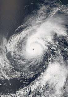
- 21:00 UTC (11:00 a.m. HST) at 15°12′N 143°06′W / 15.2°N 143.1°W – Hurricane Hector reaches peak intensity as a high-end Category 4 hurricane with winds of 155 mph (250 km/h) and a minimum pressure of 936 mbar (hPa; 27.64 inHg) roughly 850 miles (1365 km) east-southeast of Hilo, Hawaii.[75]
- 21:00 UTC (3:00 p.m. MDT) at 16°00′N 108°00′W / 16.0°N 108.0°W – Tropical Storm John intensifies into a Category 1 hurricane approximately 320 miles (515 km) southwest of Manzanillo, Colima.[76]
August 7
- 05:00 UTC (10:00 p.m. PDT August 6) at 14°30′N 124°18′W / 14.5°N 124.3°W – Tropical Depression Thirteen-E develops from an area of low pressure about 1105 miles (1780 km) west-southwest of the southern tip of the Baja California peninsula.[77]
- 09:00 UTC (2:00 a.m. PDT) at 14°18′N 125°06′W / 14.3°N 125.1°W – Tropical Depression Thirteen-E intensifies into Tropical Storm Kristy roughly 1155 miles (1860 km) west-southwest of the southern tip of Baja California.[78]
- 15:00 UTC (9:00 a.m. MDT) at 20°30′N 109°00′W / 20.5°N 109.0°W – Tropical Storm Ileana dissipates after undergoing a Fujiwara interaction with nearby Hurricane John approximately 175 miles (280 km) south-southeast of the southern tip of Baja California.[79]
- 15:00 UTC (9:00 a.m. MDT) at 17°54′N 109°48′W / 17.9°N 109.8°W – Hurricane John intensifies into a Category 2 hurricane approximately 320 miles (510 km) west-southwest of Cabo Corrientes, Jalisco, simultaneously reaching peak intensity with winds of 105 mph (165 km/h) and a central pressure of 969 mbar (hPa; 28.62 inHg).[80]
August 8
- 09:00 UTC (11:00 p.m. HST August 7) at 16°30′N 152°12′W / 16.5°N 152.2°W – Hurricane Hector weakens to a Category 3 hurricane approximately 290 miles (470 km) southeast of Hilo, Hawaii.[81]
- 15:00 UTC (9:00 a.m. MDT) at 20°42′N 112°18′W / 20.7°N 112.3°W – Hurricane John weakens into a Category 1 hurricane about 215 miles (350 km) southwest of the southern tip of Baja California.[82]
August 9
- 09:00 UTC (3:00 a.m. MDT) at 23°42′N 115°54′W / 23.7°N 115.9°W – Hurricane John weakens to a tropical storm about 385 miles (620 km) west of the southern tip of Baja California.[83]
August 10
- 09:00 UTC (11:00 p.m. HST August 9) at 17°24′N 164°24′W / 17.4°N 164.4°W – Hurricane Hector re-intensifies into a Category 4 hurricane approximately 500 miles (805 km) west-southwest of Honolulu, Hawaii.[84]
- 09:00 UTC (2:00 a.m. PDT) at 18°12′N 129°48′W / 18.2°N 129.8°W – Tropical Storm Kristy reaches its peak intensity with winds of 70 mph (110 km/h) and a minimum pressure of 991 mbar (hPa; 29.27 inHg) approximately 1325 miles (2135 km) west of the southern tip of Baja California.[85]
- 15:00 UTC (8:00 a.m. PDT) at 26°48′N 121°06′W / 26.8°N 121.1°W – Tropical Storm John transitions into a post-tropical cyclone about 475 miles (760 km) south-southwest of San Diego, California.[86]
August 11
- 09:00 UTC (11:00 p.m. HST August 10) at 18°42′N 169°12′W / 18.7°N 169.2°W – Hurricane Hector weakens into a Category 3 hurricane approximately 140 miles (225 km) north of Johnston Atoll.[87]
- 15:00 UTC (8:00 a.m. PDT) at 21°24′N 131°00′W / 21.4°N 131.0°W – Tropical Storm Kristy transitions into a post-tropical cyclone about 475 miles (760 km) south-southwest of San Diego, California.[88]
- 21:00 UTC (11:00 a.m. HST) at 20°06′N 170°54′W / 20.1°N 170.9°W – Hurricane Hector weakens into a Category 2 hurricane roughly 695 miles (1115 km) southeast of Midway Island.[89]
August 12
- 09:00 UTC (11:00 p.m. HST August 11) at 22°06′N 172°54′W / 22.1°N 172.9°W – Hurricane Hector weakens into a Category 1 hurricane approximately 505 miles (815 km) southeast of Midway Island.[90]
August 13
- 03:00 UTC (5:00 p.m. HST August 12) at 24°36′N 177°00′W / 24.6°N 177.0°W – Hurricane Hector weakens into a tropical storm roughly 250 miles (400 km) south of Midway Island.[91]
- 15:00 UTC (5:00 a.m. HST) at 25°18′N 179°48′E / 25.3°N 179.8°E – Tropical Storm Hector crosses the International Date Line with winds of 50 mph (85 km/h) roughly 250 miles (400 km) southwest of Midway Island.[92]
August 15
- 03:00 UTC (8:00 p.m. PDT August 14) at 10°54′N 121°12′W / 10.9°N 121.2°W – Tropical Depression Fourteen-E forms from an area of low pressure approximately 1115 miles (1795 km) southwest of the southern tip of Baja California.[93]
- 15:00 UTC (8:00 a.m. PDT) at 10°42′N 123°36′W / 10.7°N 123.6°W – Tropical Depression Fourteen-E intensifies into Tropical Storm Lane roughly 1235 miles (1990 km) southwest of the southern tip of Baja California.[94]
August 17
- 03:00 UTC (8:00 p.m. PDT August 16) at 11°12′N 129°48′W / 11.2°N 129.8°W – Tropical Storm Lane intensifies into a Category 1 hurricane approximately 1540 miles (2475 km) west-southwest of the southern tip of Baja California.[95]
- 15:00 UTC (8:00 a.m. PDT) at 11°12′N 132°54′W / 11.2°N 132.9°W – Hurricane Lane intensifies further into a Category 2 hurricane about 1715 miles (2760 km) west-southwest of the southern tip of Baja California.[96]
August 18
- 03:00 UTC (8:00 p.m. PDT August 17) at 11°48′N 135°36′W / 11.8°N 135.6°W – Hurricane Lane intensifies into a Category 3 hurricane approximately 1405 miles (2260 km) east-southeast of Hilo, Hawaii.[97]
- 09:00 UTC (2:00 a.m. PDT) at 12°06′N 137°00′W / 12.1°N 137.0°W - Hurricane Lane intensifies into a Category 4 hurricane approximately 1310 miles (2110 km) east-southeast of Hilo, Hawaii.[98]
August 19
- 03:00 UTC (5:00 p.m. HST August 18) at 12°48′N 141°00′W / 12.8°N 141.0°W – Hurricane Lane crosses into the Central Pacific basin and into the CPHC area of responsibility with winds of 130 mph (215 km/h) roughly 1050 miles (1685 km) east-southeast of Hilo, Hawaii.[99]
- 09:00 UTC (11:00 p.m. HST) at 12°54′N 142°18′W / 12.9°N 142.3°W - Hurricane Lane weakens into a Category 3 hurricane approximately 970 miles (1560 km) east-southeast of Hilo, Hawaii.[100]
August 20
- 21:00 UTC (11:00 a.m. HST) at 13°36′N 149°06′W / 13.6°N 149.1°W - Hurricane Lane re-intensifies into a Category 4 hurricane approximately 580 miles (930 km) southeast of Hilo, Hawaii.[101]
August 22
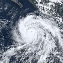
- 04:20 UTC (6:20 p.m. HST August 21) at 14°30′N 154°00′W / 14.5°N 154.0°W – Hurricane Lane intensifies into a Category 5 hurricane about 375 miles (605 km) south-southeast of Kailua-Kona, Hawaii.[102]
- 15:00 UTC (5:00 a.m. HST) at 15°06′N 155°18′W / 15.1°N 155.3°W – Hurricane Lane weakens into a Category 4 hurricane roughly 315 miles (505 km) south of Kailua-Kona, Hawaii.[103]
August 24
- 00:00 UTC (2:00 p.m. HST August 23) at 17°30′N 157°48′W / 17.5°N 157.8°W – Hurricane Lane weakens into a Category 3 hurricane approximately 190 miles (305 km) southwest of Kailua-Kona, Hawaii. [104]
- 15:00 UTC (5:00 a.m. HST) at 18°42′N 158°00′W / 18.7°N 158.0°W – Hurricane Lane weakens into a Category 2 hurricane approximately 180 miles (290 km) south of Honolulu, Hawaii. [105]
August 25
- 00:00 UTC (2:00 p.m. HST August 24) at 19°36′N 157°48′W / 19.6°N 157.8°W – Hurricane Lane rapidly weakens into a Category 1 hurricane approximately 120 miles (190 km) south of Honolulu, Hawaii. [106]
- 03:00 UTC (5:00 p.m. HST August 24) at 19°12′N 158°24′W / 19.2°N 158.4°W – Hurricane Lane weakens into a tropical storm approximately 150 miles (240 km) south-southwest of Honolulu, Hawaii. [107]
August 26
- 09:00 UTC (2:00 a.m. PDT) at 13°18′N 124°06′W / 13.3°N 124.1°W – Tropical Depression Fifteen-E forms from an area of low pressure approximately 1140 miles (1840 km) west-southwest of the southern tip of Baja California.[108]
- 15:00 UTC (5:00 a.m. HST) at 19°06′N 162°12′W / 19.1°N 162.2°W – Tropical Storm Lane weakens into a tropical depression approximately 315 miles (510 km) west-southwest of Honolulu, Hawaii. [109]
- 15:00 UTC (8:00 p.m. PDT) at 13°12′N 125°18′W / 13.2°N 125.3°W – Tropical Depression Fifteen-E intensifies into Tropical Storm Miriam approximately 1210 miles (1950 km) west-southwest of the southern tip of Baja California.[110]
August 27
- 15:00 UTC (5:00 a.m. HST) at 18°54′N 165°30′W / 18.9°N 165.5°W – Tropical Depression Lane re-intensifies into a tropical storm approximately 430 miles (690 km) west-southwest of Barking Sands, Hawaii. [111]
August 28
- 03:00 UTC (5:00 p.m. HST August 27) at 18°30′N 166°36′W / 18.5°N 166.6°W – Tropical Storm Lane weakens into a tropical depression approximately 595 miles (960 km) west-southwest of Honolulu, Hawaii. [112]
- 15:00 UTC (9:00 a.m. MDT) at 17°06′N 111°48′W / 17.1°N 111.8°W – Tropical Depression Sixteen-E forms from an area of low pressure approximately 420 miles (675 km) south-southwest of the southern tip of Baja California. [113]
August 29
- 03:00 UTC (5:00 p.m. HST August 28) at 19°30′N 168°18′W / 19.5°N 168.3°W – Tropical Depression Lane weakens into a remnant low approximately 330 miles (530 km) south-southwest of French Frigate Shoals, Hawaii. [114]
- 03:00 UTC (9:00 p.m. MDT August 28) at 17°30′N 113°54′W / 17.5°N 113.9°W – Tropical Depression Sixteen-E intensifies into Tropical Storm Norman roughly 455 miles (730 km) southwest of the southern tip of Baja California.[115]
- 21:00 UTC (2:00 p.m. PDT) at 14°00′N 139°42′W / 14.0°N 139.7°W – Tropical Storm Miriam intensifies into a Category 1 hurricane and simultaneously crosses into the Central Pacific area of responsibility with winds of 75 mph (120 km/h) approximately 420 miles (675 km) south-southwest of the southern tip of Baja California. [116]
- 21:00 UTC (2:00 p.m. PDT) at 17°36′N 116°06′W / 17.6°N 116.1°W – Tropical Storm Norman intensifies into a Category 1 hurricane approximately 545 miles (875 km) southwest of the southern tip of Baja California. [117]
August 30
- 09:00 UTC (2:00 a.m. PDT) at 17°48′N 117°24′W / 17.8°N 117.4°W – Hurricane Norman rapidly intensifies into a Category 3 hurricane approximately 600 miles (965 km) southwest of the southern tip of Baja California. [118]
- 12:30 UTC (5:30 a.m. PDT) at 17°48′N 117°42′W / 17.8°N 117.7°W – Hurricane Norman intensifies into a Category 4 hurricane approximately 615 miles (990 km) west-southwest of the southern tip of Baja California. [119]
November
November 30
- The 2018 Pacific hurricane season officially ends.[1]
See also
References
- 1 2 3 4 Christopher W. Landsea; Neal Dorst; Erica Rule (June 2, 2011). "G: Tropical Cyclone Climatology". Hurricane Research Division: Frequently Asked Questions. Atlantic Oceanographic and Meteorological Laboratory. National Oceanic and Atmospheric Administration. G1) When is hurricane season ?. Retrieved May 28, 2018.
- ↑ Robbie J. Berg (May 28, 2015). Tropical Depression One-E Discussion Number 1 (Report). Miami, Florida: National Hurricane Center. Retrieved May 28, 2018.
- ↑ Lixion A. Avila (May 10, 2018). Tropical Depression One-E Advisory Number 1 (Report). Miami, Florida: National Hurricane Center. Retrieved May 28, 2018.
- ↑ John L. Beven II (May 10, 2018). Tropical Depression One-E Advisory Number 2 (Report). Miami, Florida: National Hurricane Center. Retrieved May 28, 2018.
- ↑ John L. Beven II (May 11, 2018). Post-Tropical Cyclone One-E Advisory Number 6 (Report). Miami, Florida: National Hurricane Center. Retrieved May 28, 2018.
- ↑ Robbie J. Berg (June 5, 2018). Tropical Depression Two-E Advisory Number 1 (Report). Miami, Florida: National Hurricane Center. Retrieved June 6, 2018.
- ↑ Robbie J. Berg (June 6, 2018). Tropical Storm Aletta Advisory Number 2 (Report). Miami, Florida: National Hurricane Center. Retrieved June 6, 2018.
- ↑ Richard J. Pasch (June 7, 2018). Hurricane Aletta Advisory Number 8 (Report). Miami, Florida: National Hurricane Center. Retrieved June 7, 2018.
- ↑ Robbie J. Berg (June 7, 2018). Hurricane Aletta Advisory Number 9 (Report). Miami, Florida: National Hurricane Center. Retrieved June 7, 2018.
- ↑ Eric S. Blake (June 8, 2018). Hurricane Aletta Special Advisory Number 10 (Report). Miami, Florida: National Hurricane Center. Retrieved June 8, 2018.
- ↑ David P. Zelinsky (June 8, 2018). Hurricane Aletta Advisory Number 12 (Report). Miami, Florida: National Hurricane Center. Retrieved June 8, 2018.
- ↑ Robbie J. Berg (June 8, 2018). Hurricane Aletta Public Advisory Number 14 (Report). Miami, Florida: National Hurricane Center. Retrieved June 8, 2018.
- ↑ Daniel P. Brown (June 9, 2018). Hurricane Aletta Public Advisory Number 15 (Report). Miami, Florida: National Hurricane Center. Retrieved June 9, 2018.
- ↑ Jack Beven (June 9, 2018). Hurricane Aletta Public Advisory Number 17 (Report). Miami, Florida: National Hurricane Center. Retrieved June 9, 2018.
- ↑ David P. Zelinsky (June 9, 2018). Tropical Depression Three-E Advisory Number 1 (Report). Miami, Florida: National Hurricane Center. Retrieved June 9, 2018.
- ↑ Robbie J. Berg (June 9, 2018). Tropical Storm Aletta Public Advisory Number 18 (Report). Miami, Florida: National Hurricane Center. Retrieved June 9, 2018.
- ↑ Lixion A. Avila (June 9, 2018). Tropical Storm Bud Advisory Number 2 (Report). Miami, Florida: National Hurricane Center. Retrieved June 9, 2018.
- ↑ Lixion A. Avila (June 10, 2018). Hurricane Bud Advisory Number 5 (Report). Miami, Florida: National Hurricane Center. Retrieved June 10, 2018.
- ↑ Richard J. Pasch (June 11, 2018). Hurricane Bud Advisory Number 7 (Report). Miami, Florida: National Hurricane Center. Retrieved June 11, 2018.
- ↑ Stacy R. Stewart (June 11, 2018). Tropical Depression Aletta Public Advisory Number 24 (Report). Miami, Florida: National Hurricane Center. Retrieved June 11, 2018.
- ↑ Lixion A. Avila (June 11, 2018). Hurricane Bud Advisory Number 8 (Report). Miami, Florida: National Hurricane Center. Retrieved June 11, 2018.
- ↑ Stacy R. Stewart (June 11, 2018). Post-tropical Cyclone Aletta Public Advisory Number 25 (Report). Miami, Florida: National Hurricane Center. Retrieved June 11, 2018.
- ↑ Richard J. Pasch (June 12, 2018). Hurricane Bud Advisory Number 11 (Report). Miami, Florida: National Hurricane Center. Retrieved June 12, 2018.
- ↑ Stacy R. Stewart (June 12, 2018). Hurricane Bud Advisory Number 12 (Report). Miami, Florida: National Hurricane Center. Retrieved June 12, 2018.
- ↑ Robbie J. Berg (June 12, 2018). Hurricane Bud Advisory Number 14 (Report). Miami, Florida: National Hurricane Center. Retrieved June 12, 2018.
- ↑ Stacy R. Stewart (June 13, 2018). Tropical Storm Bud Intermediate Advisory Number 15A (Report). Miami, Florida: National Hurricane Center. Retrieved June 13, 2018.
- ↑ Eric S. Blake (June 14, 2018). Tropical Depression Four-E Advisory Number 1 (Report). Miami, Florida: National Hurricane Center. Retrieved June 14, 2018.
- ↑ John P. Cangialosi (June 14, 2018). Tropical Storm Bud Advisory Number 22 (Report). Miami, Florida: National Hurricane Center. Retrieved June 14, 2018.
- ↑ Michael J. Brennan (June 15, 2018). Tropical Depression Bud Advisory Number 24 (Report). Miami, Florida: National Hurricane Center. Retrieved June 15, 2018.
- ↑ Eric S. Blake (June 15, 2018). Tropical Storm Carlotta Intermediate Advisory Number 4A (Report). Miami, Florida: National Hurricane Center. Retrieved June 15, 2018.
- ↑ Michael J. Brennan (June 15, 2018). Post-Tropical Cyclone Bud Advisory Number 25 (Report). Miami, Florida: National Hurricane Center. Retrieved July 3, 2018.
- ↑ John P. Cangialosi; Eric S. Blake (June 16, 2018). Tropical Storm Carlotta Tropical Cyclone Update (Report). Miami, Florida: National Hurricane Center. Retrieved July 3, 2018.
- ↑ Richard J. Pasch (June 17, 2018). Tropical Depression Carlotta Intermediate Advisory Number 12A (Report). Miami, Florida: National Hurricane Center. Retrieved June 17, 2018.
- ↑ Stacy R. Stewart (June 18, 2018). Post-Tropical Cyclone Carlotta Advisory Number 18 (Report). Miami, Florida: National Hurricane Center. Retrieved July 3, 2018.
- ↑ David P. Zelinsky (June 23, 2018). Tropical Depression Five-E Advisory Number 1 (Report). Miami, Florida: National Hurricane Center. Retrieved June 23, 2018.
- ↑ Jack Beven (June 24, 2018). Tropical Storm Daniel Public Advisory Number Three (Report). National Hurricane Center. Retrieved July 8, 2018.
- ↑ Jack Beven (June 24, 2018). Tropical Storm Daniel Public Advisory Number Four (Report). National Hurricane Center. Retrieved July 9, 2018.
- ↑ Jack Beven (June 25, 2018). Tropical Depression Daniel Public Advisory Number Eight (Report). National Hurricane Center. Retrieved July 9, 2018.
- ↑ Jack Beven (June 26, 2018). Post-Tropical Cyclone Daniel Advisory Number 11 (Report). National Hurricane Center. Retrieved July 9, 2018.
- ↑ Eric S. Blake (June 27, 2018). Tropical Depression Six-E Advisory Number One (Report). National Hurricane Center. Retrieved July 9, 2018.
- ↑ Stacy R. Stewart (June 28, 2018). Tropical Storm Emilia Advisory Number Three (Report). National Hurricane Center. Retrieved July 9, 2018.
- ↑ Dave Roberts (June 29, 2018). Tropical Storm Emilia Advisory Number Eight (Report). National Hurricane Center. Retrieved July 9, 2018.
- ↑ Lixion A. Avila (June 30, 2018). Tropical Depression Emilia Advisory Number 12 (Report). National Hurricane Center. Retrieved July 9, 2018.
- ↑ Lixion A. Avila (June 30, 2018). Tropical Depression Seven Public Advisory Number 1 (Report). National Hurricane Center. Retrieved July 9, 2018.
- ↑ John P. Cangialosi (July 1, 2018). Post-Tropical Cyclone Emilia Advisory Number 18 (Report). National Hurricane Center. Retrieved July 9, 2018.
- ↑ John L. Beven II (July 1, 2018). Tropical Storm Fabio Public Advisory Number 3 (Report). National Hurricane Center. Retrieved July 9, 2018.
- ↑ Daniel P. Brown (July 2, 2018). Hurricane Fabio Public Advisory Number 8 (Report). National Hurricane Center. Retrieved July 9, 2018.
- ↑ David A. Zelinsky (July 3, 2018). Hurricane Fabio Public Advisory Number 12 (Report). National Hurricane Center. Retrieved July 9, 2018.
- ↑ Daniel P. Brown (July 3, 2018). Hurricane Fabio Public Advisory Number 13 (Report). National Hurricane Center. Retrieved July 9, 2018.
- ↑ David A. Zelinsky (July 4, 2018). Hurricane Fabio Public Advisory Number 17 (Report). National Hurricane Center. Retrieved July 9, 2018.
- ↑ Lixion A. Avila (July 5, 2018). Hurricane Fabio Public Advisory Number 19 (Report). National Hurricane Center. Retrieved July 9, 2018.
- ↑ Lixion A. Avila (July 6, 2018). Post-Tropical Cyclone Fabio Public Advisory Number 24 (Report). National Hurricane Center. Retrieved July 9, 2018.
- ↑ Lixion A. Avila (July 26, 2018). Tropical Depression Eight-E Advisory Number 1 (Report). National Hurricane Center. Retrieved July 26, 2018.
- ↑ John P. Cangialosi (July 26, 2018). Tropical Depression Nine-E Advisory Number 1 (Report). National Hurricane Center. Retrieved July 26, 2018.
- ↑ Jack Beven (July 27, 2018). Tropical Storm Gilma Advisory Number 3 (Report). National Hurricane Center. Retrieved July 27, 2018.
- ↑ John P. Cangialosi (July 27, 2018). Remnants of Nine-E Advisory Number 4 (Report). National Hurricane Center. Retrieved July 27, 2018.
- ↑ Lixion A. Avila; John P. Cangialosi (July 27, 2018). Tropical Depression Gilma Advisory Number 5 (Report). National Hurricane Center. Retrieved July 27, 2018.
- ↑ John P. Cangialosi (July 29, 2018). Post-Tropical Cyclone Gilma Advisory Number 13 (Report). National Hurricane Center. Retrieved July 29, 2018.
- ↑ Stacy R. Stewart (July 31, 2018). Tropical Depression Ten-E Advisory Number 1 (Report). National Hurricane Center. Retrieved July 31, 2018.
- ↑ Dan Brown (July 31, 2018). Tropical Storm Hector Advisory Number 2 (Report). National Hurricane Center. Retrieved July 31, 2018.
- ↑ Robbie J. Berg; Michael J. Brennan (August 2, 2018). Hurricane Hector Tropical Cyclone Update (Report). National Hurricane Center. Retrieved August 2, 2018.
- ↑ Eric S. Blake (August 2, 2018). Hurricane Hector Advisory Number 9 (Report). National Hurricane Center. Retrieved August 2, 2018.
- ↑ Eric S. Blake (August 3, 2018). Hurricane Hector Advisory Number 12 (Report). National Hurricane Center. Retrieved August 3, 2018.
- ↑ Eric S. Blake (August 3, 2018). Hurricane Hector Advisory Number 13 (Report). National Hurricane Center. Retrieved August 3, 2018.
- ↑ Jack Beven (August 3, 2018). Hurricane Hector Advisory Number 14 (Report). National Hurricane Center. Retrieved August 3, 2018.
- ↑ Robbie J. Berg (August 4, 2018). Tropical Depression Eleven-E Advisory Number 1 (Report). National Hurricane Center. Retrieved August 4, 2018.
- ↑ Jack Beven (August 4, 2018). Hurricane Hector Advisory Number 18 (Report). National Hurricane Center. Retrieved August 4, 2018.
- ↑ Stacy R. Stewart (August 5, 2018). Hurricane Hector Advisory Number 19 (Report). National Hurricane Center. Retrieved August 5, 2018.
- ↑ Daniel P. Brown (August 5, 2018). Hurricane Hector Advisory Number 21 (Report). National Hurricane Center. Retrieved August 5, 2018.
- ↑ Richard J. Pasch (August 5, 2018). Tropical Storm Ileana Advisory Number 5 (Report). National Hurricane Center. Retrieved August 5, 2018.
- ↑ Daniel P. Brown (August 5, 2018). Tropical Depression Twelve-E Advisory Number 1 (Report). National Hurricane Center. Retrieved August 5, 2018.
- ↑ Jack Beven (August 5, 2018). Hurricane Hector Advisory Number 23 (Report). National Hurricane Center. Retrieved August 13, 2018.
- ↑ Jack Beven (August 5, 2018). Tropical Storm John Advisory Number 2 (Report). National Hurricane Center. Retrieved August 5, 2018.
- ↑ Stacy R. Stewart (August 6, 2018). Tropical Storm Ileana Advisory Number 7 (Report). National Hurricane Center. Retrieved August 11, 2018.
- ↑ Derek Wroe (August 6, 2018). Hurricane Hector Advisory Number 26 (Report). Central Pacific Hurricane Center. Retrieved August 9, 2018.
- ↑ Daniel P. Brown (August 6, 2018). Hurricane John Advisory Number 5 (Report). National Hurricane Center. Retrieved August 6, 2018.
- ↑ Eric S. Blake (August 6, 2018). Tropical Depression Thirteen-E Public Advisory Number 1 (Report). Miami, Florida: National Hurricane Center. Retrieved August 7, 2018.
- ↑ Eric S. Blake (August 7, 2018). Tropical Storm Kristy Advisory Number 2 (Report). National Hurricane Center. Retrieved August 7, 2018.
- ↑ Dan Brown (August 7, 2018). Remnants of Ileana Advisory Number 12 (Report). National Hurricane Center. Retrieved August 7, 2018.
- ↑ Daniel P. Brown (August 7, 2018). Hurricane John Advisory Number 8 (Report). National Hurricane Center. Retrieved August 9, 2018.
- ↑ Sam Houston (August 7, 2018). Hurricane Hector Advisory Number 32 (Report). Central Pacific Hurricane Center. Retrieved August 9, 2018.
- ↑ Daniel P. Brown (August 8, 2018). Hurricane John Advisory Number 12 (Report). National Hurricane Center. Retrieved August 9, 2018.
- ↑ Eric S. Blake (August 9, 2018). Tropical Storm John Advisory Number 15 (Report). National Hurricane Center. Retrieved August 9, 2018.
- ↑ Sam Houston (August 9, 2018). Hurricane Hector Advisory Number 40 (Report). Central Pacific Hurricane Center. Retrieved August 11, 2018.
- ↑ Jack Beven (August 10, 2018). Tropical Storm Kristy Advisory Number 14 (Report). National Hurricane Center. Retrieved August 11, 2018.
- ↑ Lixion A. Avila (August 10, 2018). Post-tropical Cyclone John Advisory Number 20 (Report). National Hurricane Center. Retrieved August 11, 2018.
- ↑ Tom Birchard (August 10, 2018). Hurricane Hector Advisory Number 44 (Report). Central Pacific Hurricane Center. Retrieved August 11, 2018.
- ↑ Lixion A. Avila (August 11, 2018). Post-Tropical Cyclone Kristy Advisory Number 19 (Report). National Hurricane Center. Retrieved August 11, 2018.
- ↑ Jeff Powell (August 11, 2018). Hurricane Hector Advisory Number 46 (Report). Central Pacific Hurricane Center. Retrieved August 11, 2018.
- ↑ Jon Jelsema (August 11, 2018). Hurricane Hector Advisory Number 48 (Report). Central Pacific Hurricane Center. Retrieved August 12, 2018.
- ↑ Robert Burke (August 12, 2018). Tropical Storm Hector Advisory Number 51 (Report). Central Pacific Hurricane Center. Retrieved August 12, 2018.
- ↑ Sam Houston (August 13, 2018). Tropical Storm Hector Advisory Number 53 (Report). Central Pacific Hurricane Center. Retrieved August 13, 2018.
- ↑ Stacy R. Stewart (August 14, 2018). Tropical Depression Fourteen-E Advisory Number 1 (Report). National Hurricane Center. Retrieved August 14, 2018.
- ↑ Eric S. Blake (August 15, 2018). Tropical Storm Lane Advisory Number 3 (Report). National Hurricane Center. Retrieved August 15, 2018.
- ↑ Stacy R. Stewart (August 16, 2018). Hurricane Lane Advisory Number 9 (Report). National Hurricane Center. Retrieved August 16, 2018.
- ↑ Dave P. Roberts (August 17, 2018). Hurricane Lane Advisory Number 11 (Report). National Hurricane Center. Retrieved August 17, 2018.
- ↑ Jack Beven (August 17, 2018). Hurricane Lane Advisory Number 13 (Report). National Hurricane Center. Retrieved August 17, 2018.
- ↑ Lixion A. Avila (August 18, 2018). Hurricane Lane Advisory Number 14 (Report). National Hurricane Center. Retrieved August 18, 2018.
- ↑ Jeff Powell (August 18, 2018). Hurricane Lane Advisory Number 17 (Report). Central Pacific Hurricane Center. Retrieved August 18, 2018.
- ↑ Sam Houston (August 19, 2018). Hurricane Lane Advisory Number 18 (Report). Central Pacific Hurricane Center. Retrieved August 19, 2018.
- ↑ Sam Houston (August 20, 2018). Hurricane Lane Advisory Number 24 (Report). Central Pacific Hurricane Center. Retrieved August 20, 2018.
- ↑ Tom Birchard; Chris Jacobson (August 21, 2018). Hurricane Lane Tropical Cyclone Update (Report). Central Pacific Hurricane Center. Retrieved August 22, 2018.
- ↑ Jeff Powell (August 22, 2018). Hurricane Lane Advisory Number 32 (Report). Central Pacific Hurricane Center. Retrieved August 23, 2018.
- ↑ Robert Ballard (August 23, 2018). Hurricane Lane Advisory Number 37A (Report). Central Pacific Hurricane Center. Retrieved August 23, 2018.
- ↑ Sam Houston (August 24, 2018). Hurricane Lane Advisory Number 40 (Report). Central Pacific Hurricane Center. Retrieved August 24, 2018.
- ↑ Robert Ballard (August 24, 2018). Hurricane Lane Advisory Number 42 (Report). Central Pacific Hurricane Center. Retrieved August 24, 2018.
- ↑ Robert Ballard (August 24, 2018). Tropical Storm Lane Advisory Number 43 (Report). Central Pacific Hurricane Center. Retrieved August 24, 2018.
- ↑ Stacy R. Stewart (August 26, 2018). Tropical Depression Fifteen-E Advisory Number 1 (Report). National Hurricane Center. Retrieved August 26, 2018.
- ↑ Tom Birchard (August 26, 2018). Tropical Depression Lane Advisory Number 49 (Report). Central Pacific Hurricane Center. Retrieved August 26, 2018.
- ↑ Daniel P. Brown (August 26, 2018). Tropical Storm Miriam Advisory Number 2 (Report). National Hurricane Center. Retrieved August 26, 2018.
- ↑ Tom Birchard (August 27, 2018). Tropical Storm Lane Advisory Number 53 (Report). Central Pacific Hurricane Center. Retrieved August 27, 2018.
- ↑ Patrick Donaldson (August 27, 2018). Tropical Depression Lane Advisory Number 55 (Report). Central Pacific Hurricane Center. Retrieved August 27, 2018.
- ↑ Lixion A. Avila (August 28, 2018). Tropical Depression Sixteen-E Advisory Number 1 (Report). National Hurricane Center. Retrieved August 29, 2018.
- ↑ Patrick Donaldson (August 28, 2018). Post-Tropical Cyclone Lane Advisory Number 59 (Report). Central Pacific Hurricane Center. Retrieved August 29, 2018.
- ↑ Richard J. Pasch (August 28, 2018). Tropical Storm Norman Advisory Number 3 (Report). National Hurricane Center. Retrieved August 29, 2018.
- ↑ Daniel P. Brown (August 29, 2018). Hurricane Miriam Advisory Number 15 (Report). National Hurricane Center. Retrieved August 29, 2018.
- ↑ Lixion A. Avila (August 29, 2018). Hurricane Miriam Advisory Number 6 (Report). National Hurricane Center. Retrieved August 29, 2018.
- ↑ Robbie J. Berg (August 30, 2018). Hurricane Norman Advisory Number 8 (Report). National Hurricane Center. Retrieved August 30, 2018.
- ↑ Daniel P. Brown (August 30, 2018). Hurricane Norman Advisory Number 9 (Report). National Hurricane Center. Retrieved August 30, 2018.
External links
| Wikimedia Commons has media related to 2018 Pacific hurricane season. |
- The National Hurricane Center's advisory archive for 2018
Tropical cyclones of the 2018 Pacific hurricane season | ||
|---|---|---|
| ||
| ||
| Preceded by 2017 |
Pacific hurricane season timelines 2018 |
Succeeded by 2019 |