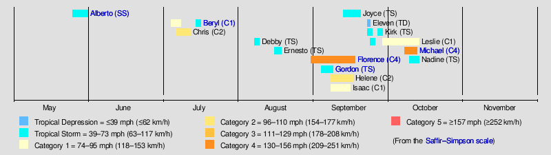
Timeline of the 2018 Atlantic hurricane season
The 2018 Atlantic hurricane season is an event in the annual tropical cyclone season in the Northern Hemisphere. The season officially began on June 1, 2018 and will end on November 30, 2018. These dates, adopted by convention, historically describe the period in each year when most systems form.[1] However, systems can and do form outside these dates, shown by the formation of Subtropical Storm Alberto on May 25.
This timeline documents tropical cyclone formations, strengthening, weakening, landfalls, extratropical transitions, and dissipations during the season. It includes information that was not released throughout the season, meaning that data from post-storm reviews by the National Hurricane Center, such as a storm that was not initially warned upon, has been included.
Timeline of events
May
May 25
- 15:00 UTC (10:00 a.m. CDT) at 19°42′N 86°48′W / 19.7°N 86.8°W – Subtropical Storm Alberto develops from an area of low pressure situated about 55 miles (90 km) to the south of Cozumel, Quintana Roo.[2]
May 28
- 00:00 UTC (7:00 p.m. CDT May 27) at 28°18′N 85°36′W / 28.3°N 85.6°W – Subtropical Storm Alberto attains peak winds of 65 mph (100 km/h) roughly 190 miles (305 km) west of Tampa, Florida.[3]
- 06:00 UTC (1:00 a.m. CDT) at 28°36′N 86°06′W / 28.6°N 86.1°W – Subtropical Storm Alberto attains a minimum barometric pressure of 990 mbar (hPa; 29.23 inHg) approximately 115 miles (185 km) south-southwest of Panama City, Florida.[4]
- 21:00 UTC (4:00 p.m. CDT) at 30°18′N 85°54′W / 30.3°N 85.9°W – Subtropical Storm Alberto makes landfall near Laguna Beach, Florida with winds of 45 mph (75 mph).[5]
May 29
- 03:00 UTC (10:00 p.m. CDT May 28) at 31°24′N 86°12′W / 31.4°N 86.2°W – Subtropical Storm Alberto weakens to a subtropical depression over land, located about 50 miles (80 km) west-northwest of Dothan, Alabama.[6]
May 30
- 03:00 UTC (10:00 p.m. CDT May 29) at 36°18′N 87°30′W / 36.3°N 87.5°W – Subtropical Depression Alberto transitions to a tropical depression over land, around 45 miles (75 km) west-northwest of Nashville, Tennessee.[7]
May 31
- 09:00 UTC (5:00 a.m. EDT) at 44°54′N 83°54′W / 44.9°N 83.9°W – Tropical Depression Alberto degrades to a post-tropical cyclone approximately 20 miles (30 km) west-southwest of Alpena, Michigan.[8]
June
June 1
- The 2018 Atlantic hurricane season officially begins.[1]
- No tropical cyclones form in the Atlantic Ocean during the month of June.
July
July 5
- 15:00 UTC (11:00 a.m. AST) at 10°12′N 41°24′W / 10.2°N 41.4°W – Tropical Depression Two develops from an area of low pressure about 1385 miles (2230 km) east-southeast of the Lesser Antilles.[9]
- 18:30 UTC (2:30 p.m. AST) at 10°18′N 42°18′W / 10.3°N 42.3°W – Tropical Depression Two strengthens into Tropical Storm Beryl approximately 1330 miles (2140 km) east-southeast of the Lesser Antilles.[10]
July 6
- 09:00 UTC (05:00 a.m. AST) at 10°36′N 45°06′W / 10.6°N 45.1°W – Tropical Storm Beryl strengthens into a Category 1 hurricane about 1105 miles (1830 km) east-southeast of the Lesser Antilles.[11]
- 15:00 UTC (11:00 a.m. AST) at 10°42′N 46°30′W / 10.7°N 46.5°W – Hurricane Beryl attains peak intensity with winds of 80 mph (130 km/h) and a minimum barometric pressure of 994 mbar (hPa; 29.36 inHg) approximately 1045 miles (1685 km) east-southeast of the Lesser Antilles.[12]
- 21:00 UTC (5:00 p.m. EDT) at 32°12′N 73°48′W / 32.2°N 73.8°W – Tropical Depression Three forms approximately 230 miles (370 km) south-southeast of Cape Hatteras, North Carolina.[13]
July 7
- 15:00 UTC (11:00 a.m. AST) at 12°06′N 51°06′W / 12.1°N 51.1°W – Hurricane Beryl weakens to a tropical storm approximately 720 miles (1160 km) east-southeast of the Lesser Antilles.[14]
July 8
- 09:00 UTC (5:00 a.m. EDT) at 33°00′N 75°30′W / 33.0°N 75.5°W – Tropical Depression Three strengthens into Tropical Storm Chris roughly 150 miles (245 km) south of Cape Hatteras, North Carolina.[15]
- 21:00 UTC (5:00 a.m. AST) at 15°12′N 70°30′W / 15.2°N 70.5°W – Tropical Storm Beryl opens up into a tropical wave while located 60 miles east of Guadeloupe.[16]
July 10
- 21:00 UTC (5:00 p.m. EDT) at 33°42′N 72°24′W / 33.7°N 72.4°W – Tropical Storm Chris strengthens to a Category 1 hurricane roughly 205 miles (330 km) east-southeast of Cape Hatteras, North Carolina.[17]
July 11
- 03:00 UTC (11:00 p.m. EDT July 10) at 34°12′N 71°24′W / 34.2°N 71.4°W – Hurricane Chris strengthens to a Category 2 hurricane and reaches a peak intensity of 105 mph (165 km/h) and a minimum barometric pressure of 970 mbar (hPa; 28.65 inHg) about 245 miles (390 km) east-southeast of Cape Hatteras, North Carolina.[18]
- 21:00 UTC (05:00 p.m. EDT) at 37°48′N 65°42′W / 37.8°N 65.7°W – Hurricane Chris weakens to a Category 1 hurricane about 570 miles (920 km) east-northeast of Cape Hatteras, North Carolina.[19]
July 12
- 09:00 UTC (5:00 a.m. AST) at 42°06′N 60°06′W / 42.1°N 60.1°W – Hurricane Chris weakens to a tropical storm roughly 245 miles (395 km) southeast of Halifax, Nova Scotia.[20]
- 15:00 UTC (11:00 a.m. AST) at 44°24′N 57°42′W / 44.4°N 57.7°W – Tropical Storm Chris transitions to a post-tropical cyclone about 275 miles (440 km) southwest of Cape Race, Newfoundland.[21]
July 14
- 17:00 UTC (1:00 p.m. AST) at 36°24′N 65°42′W / 36.4°N 65.7°W – The remnants of Beryl regenerate into a subtropical storm while located about 290 miles (465 km) north of Bermuda.[22]
July 16
- 03:00 UTC (11:00 p.m. EDT July 15) at 38°36′N 62°24′W / 38.6°N 62.4°W – Subtropical Storm Beryl weakens to a remnant low roughly 455 miles (735 km) north-northeast of Bermuda. [23]
August
August 7
- 15:00 UTC (11:00 a.m. EDT) at 38°54′N 48°30′W / 38.9°N 48.5°W – Subtropical Storm Debby forms from an area of low pressure about 1160 miles (1870 km) west of the Azores.[24]
- 09:00 UTC (5:00 a.m. AST) at 40°48′N 48°48′W / 40.8°N 48.8°W – Subtropical Storm Debby transitions into a tropical storm about 1175 miles (1890 km) west-northwest of the Azores.[25]
- 21:00 UTC (5:00 p.m. AST) at 45°30′N 40°30′W / 45.5°N 40.5°W – Tropical Storm Debby transitions into a post-tropical cyclone about 865 miles (1390 km) northwest of the Azores.[26]
August 15
- 09:00 UTC (5:00 a.m. AST) at 37°36′N 45°36′W / 37.6°N 45.6°W – Subtropical Depression Five forms about 1015 miles (1630 km) west of the Azores.[27]
- 15:00 UTC (11:00 a.m. AST) at 38°06′N 46°00′W / 38.1°N 46.0°W – Subtropical Depression Five strengthens into Subtropical Storm Ernesto about 695 miles (1120 km) southeast of Cape Race, Newfoundland.[28]
August 17
- 03:00 UTC (11:00 p.m. AST August 16) at 44°06′N 38°54′W / 44.1°N 38.9°W – Subtropical Storm Ernesto transitions into a tropical storm roughly 710 miles (1145 km) east of Cape Race, Newfoundland. [29]
August 18
- 09:00 UTC (5:00 a.m. AST) at 51°54′N 20°00′W / 51.9°N 20.0°W – Tropical Storm Ernesto transitions into a post-tropical cyclone about 1020 miles (1640 km) north-northeast of the Azores.[30]
August 31
- 21:00 UTC (5:00 p.m. AST) at 13°48′N 24°42′W / 13.8°N 24.7°W — Tropical Depression Six forms about 70 miles (115 km) south-southwest of Cabo Verde.[31]
September
September 1
- 9:00 UTC (5:00 a.m. AST) at 14°30′N 26°42′W / 14.5°N 26.7°W — Tropical Depression Six strengthens into Tropical Storm Florence about 155 miles (250 km) west of Cabo Verde.[32]
September 2
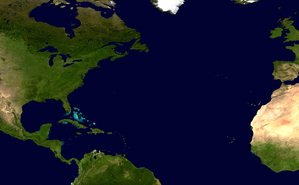
- 21:00 UTC (5:00 p.m. EDT) at 22°42′N 77°18′W / 22.7°N 77.3°W - Potential Tropical Cyclone Seven develops roughly 100 miles (155 km) north-northeast of Camaguey, Cuba.[33]
September 3
- 12:05 UTC (8:05 a.m. EDT) at 25°06′N 80°36′W / 25.1°N 80.6°W — Potential Tropical Cyclone Seven organizes into Tropical Storm Gordon roughly 10 miles (15 km) west of Key Largo, Florida. [34]
September 4
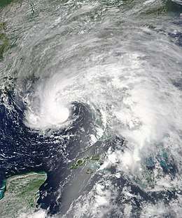
- 15:00 UTC (11:00 a.m. AST) at 19°42′N 42°30′W / 19.7°N 42.5°W — Tropical Storm Florence strengthens into a Category 1 hurricane about 1240 miles (2000 km) west-northwest of Cabo Verde.[35]
September 5
- 03:00 UTC (11:00 p.m. AST) at 20°42′N 43°54′W / 20.7°N 43.9°W — Hurricane Florence strengthens into a Category 2 hurricane about 1260 miles (2030 km) east of the Northern Leeward Islands. [36]
- 12:35 UTC (8:35 a.m. AST) at 21°42′N 45°12′W / 21.7°N 45.2°W — Hurricane Florence strengthens into a Category 3 hurricane about 1185 miles (1910 km) east-northeast of the Northern Leeward Islands. [37]
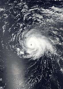
- 21:00 UTC (5:00 p.m. AST) at 22°42′N 46°36′W / 22.7°N 46.6°W - Hurricane Florence strengthens into a Category 4 hurricane about 1110 miles (1790 km) east-northeast of the Northern Leeward Islands.[38]
October
October 6
- 12:00 UTC (4:00 p.m. CDT) at 18°00′N 86°36′E / 18.0°N 86.6°E — Potential Tropical Cyclone Fourteen forms about 175 miles (280 km) south of Cozumel, Mexico.
October 7
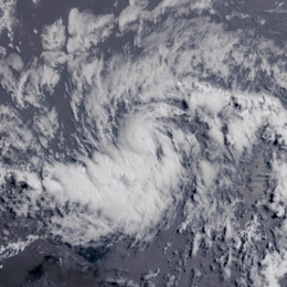
- 12:00 UTC (4:00 a.m. CDT) at 18°36′N 86°54′E / 18.6°N 86.9°E — Potential Tropical Cyclone Fourteen strengthens into Tropical Depression Fourteen about 90 miles (150 km) east of Chetumal, Mexico.
- 3:55 UTC (10:55 a.m. CDT) at 19°12′N 86°54′E / 19.2°N 86.9°E — Tropical Depression Fourteen strengthens into Tropical Storm Michael about 90 miles (145 km) south of Cozumel, Mexico.
October 8
- 15:00 UTC (11:00 a.m. EDT) at 21°12′N 84°54′E / 21.2°N 84.9°E - Tropical Storm Michael strengthens into a Category 1 hurricane about 50 miles (80 km) south of the western tip of Cuba. [39]
November
November 30
- The 2018 Atlantic hurricane season officially ends.[1]
See also
References
- 1 2 3 Christopher W. Landsea; Neal Dorst; Erica Rule (June 2, 2011). "G: Tropical Cyclone Climatology". Hurricane Research Division: Frequently Asked Questions. Atlantic Oceanographic and Meteorological Laboratory. National Oceanic and Atmospheric Administration. G1) When is hurricane season ?. Retrieved April 21, 2017.
- ↑ Stacy R. Stewart (May 25, 2018). Subtropical Storm Alberto Advisory Number 1 (Report). Miami, Florida: National Hurricane Center. Retrieved May 25, 2018.
- ↑ Richard J. Pasch (May 27, 2018). Subtropical Storm Alberto Tropical Cyclone Update (Report). Miami, Florida: National Hurricane Center. Retrieved May 28, 2018.
- ↑ John P. Cangialosi (May 28, 2018). Subtropical Storm Alberto Intermediate Advisory Number 12A (Report). Miami, Florida: National Hurricane Center. Retrieved May 28, 2018.
- ↑ Daniel P. Brown (May 28, 2018). Subtropical Storm Alberto Advisory Number 15 (Report). Miami, Florida: National Hurricane Center. Retrieved June 24, 2018.
- ↑ Richard J. Pasch (May 28, 2018). Subtropical Depression Alberto Advisory Number 16 (Report). Miami, Florida: National Hurricane Center. Retrieved June 24, 2018.
- ↑ James Hayes (May 29, 2018). Tropical Depression Alberto Advisory Number 20 (Report). College Park, Maryland: Weather Prediction Center. Retrieved June 24, 2018.
- ↑ David Roth (May 31, 2018). Post-Tropical Cyclone Alberto Advisory Number 25 (Report). College Park, Maryland: Weather Prediction Center. Retrieved June 24, 2018.
- ↑ Stacy R. Stewart (July 5, 2018). "Tropical Depression Two Public Advisory Number 1". National Hurricane Center. Retrieved July 5, 2018.
- ↑ Michael Brennan and Robbie J. Berg (July 5, 2018). "Tropical Storm Beryl Tropical Cyclone Update". National Hurricane Center. Retrieved July 8, 2018.
- ↑ Dan Brown (July 6, 2018). "Hurricane Beryl Public Advisory Number Four". National Hurricane Center. Retrieved July 8, 2018.
- ↑ Robbie J. Berg (July 6, 2018). "Hurricane Beryl Public Advisory Number Five". National Hurricane Center. Retrieved July 8, 2018.
- ↑ Lixion Avila (July 6, 2018). "Tropical Depression Three Public Advisory Number One". National Hurricane Center. Retrieved July 9, 2018.
- ↑ Robbie J. Berg (July 7, 2018). "Tropical Storm Beryl Public Advisory Number Nine". National Hurricane Center. Retrieved July 8, 2018.
- ↑ David Zelinsky (July 8, 2018). "Tropical Storm Chris Public Advisory Number Seven". National Hurricane Center. Retrieved July 8, 2018.
- ↑ Stacy R. Stewart (July 8, 2018). "Remnants of Beryl Discussion Number 14". Miami, Florida: National Hurricane Center. Retrieved July 15, 2018.
- ↑ Stacy R. Stewart (July 10, 2018). "Hurricane Chris Advisory Number 17". National Hurricane Center. Retrieved July 10, 2018.
- ↑ Jack Beven (July 10, 2018). Hurricane Chris Advisory Number 18 (Report). National Hurricane Center. Retrieved July 10, 2018.
- ↑ Stacy R. Stewart (July 11, 2018). "Hurricane Chris Advisory Number 21". Miami, Florida: National Hurricane Center. Retrieved July 11, 2018.
- ↑ Lixion Avila (July 12, 2018). "Tropical Storm Chris Advisory Number 23". National Hurricane Center. Retrieved July 12, 2018.
- ↑ Stacy Stewart (July 12, 2018). "Post-Tropical Cyclone Chris Advisory Number 24". National Hurricane Center. Retrieved July 12, 2018.
- ↑ Jack Beven (July 14, 2018). "Subtropical Storm Beryl Special Advisory Number 16". National Hurricane Center. Retrieved July 17, 2018.
- ↑ Dan Brown (July 16, 2018). "Post-Tropical Cyclone Beryl Advisory Number 22". National Hurricane Center. Retrieved July 17, 2018.
- ↑ Lixion Avila (August 7, 2018). Subtropical Storm Debby Advisory Number 1 (Report). National Hurricane Center. Retrieved August 7, 2018.
- ↑ Stacy R. Stewart (August 8, 2018). Tropical Storm Debby Advisory Number 4 (Report). National Hurricane Center. Retrieved August 9, 2018.
- ↑ David A. Zelinsky (August 9, 2018). Post-Tropical Cyclone Debby Advisory Number 10 (Report). National Hurricane Center. Retrieved August 9, 2018.
- ↑ John P. Cangialosi (August 15, 2018). Subtropical Depression Five Advisory Number 1 (Report). National Hurricane Center. Retrieved August 15, 2018.
- ↑ Daniel P. Brown (August 15, 2018). Subtropical Storm Ernesto Advisory Number 2 (Report). National Hurricane Center. Retrieved August 15, 2018.
- ↑ Jack Beven (August 16, 2018). "Tropical Storm Ernesto Advisory Number 8". National Hurricane Center. Retrieved August 16, 2018.
- ↑ Lixion A. Avila (August 18, 2018). Post-Tropical Cyclone Ernesto Advisory Number 13 (Report). National Hurricane Center. Retrieved August 18, 2018.
- ↑ Lixion Avila (August 31, 2018). "Tropical Depression Six Advisory Number 6". National Hurricane Center. Retrieved August 31, 2018.
- ↑ Robbie Berg (September 1, 2018). "Tropical Storm Florence Advisory Number 8". National Hurricane Center. Retrieved September 1, 2018.
- ↑ Stacy R. Stewart (September 2, 2018). "Optential Tropical Cyclone Seven Advisory Number 1". National Hurricane Center. Retrieved September 5, 2018.
- ↑ Michael Brennan; Stacy R. Stewart (September 5, 2018). "Tropical Storm Gordon Tropical Cyclone Update". National Hurricane Center. Retrieved September 5, 2018.
- ↑ Robbie Berg (September 4, 2018). "Hurricane Florence Advisory Number 21". National Hurricane Center. Retrieved September 4, 2018.
- ↑ Eric Blake (September 5, 2018). "Hurricane Florence Advisory Number 23". National Hurricane Center. Retrieved September 5, 2018.
- ↑ Robbie Berg; Jamie Rhome (September 5, 2018). "Hurricane Florence Advisory Update". National Hurricane Center. Retrieved September 5, 2018.
- ↑ Robbie Berg; Jamie Rhome (September 5, 2018). "Hurricane Florence Advisory Number 26". National Hurricane Center. Retrieved September 5, 2018.
- ↑ Daniel P. Brown (October 8, 2018). Hurricane Michael Advisory Number 8 (Report). Retrieved October 8, 2018.
External links
| Wikimedia Commons has media related to 2018 Atlantic hurricane season. |
Tropical cyclones of the 2018 Atlantic hurricane season | ||
|---|---|---|
| ||
| ||
| Preceded by 2017 |
Atlantic hurricane season timelines 2018 |
Succeeded by 2019 |