Hurricane Rosa (2018)
| Category 4 major hurricane (SSHWS/NWS) | |
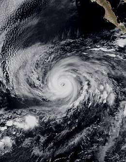 Hurricane Rosa at peak intensity southwest of Baja California Sur on September 28 | |
| Formed | September 25, 2018 |
|---|---|
| Dissipated | October 3, 2018 |
| (Remnant low after October 2) | |
| Highest winds |
1-minute sustained: 145 mph (230 km/h) |
| Lowest pressure | 940 mbar (hPa); 27.76 inHg |
| Fatalities | 15 dead, 8 missing |
| Damage | Unknown |
| Areas affected | Baja California Peninsula, Northwestern Mexico, Southwestern United States |
| Part of the 2018 Pacific hurricane season | |
Hurricane Rosa was the first tropical cyclone to make landfall in the Mexican state of Baja California since Nora in 1997. The seventeenth named storm, tenth hurricane, and seventh major hurricane of the 2018 Pacific hurricane season, Rosa originated from a broad area of low pressure that formed a couple hundred miles south of Mexico on September 22. The disturbance moved slightly north of west for a few days before developing into a tropical depression on September 25. Later that day, the depression strengthened into Tropical Storm Rosa. One day later, Rosa became a hurricane. On September 27, Rosa began a period of rapid intensification, becoming a major hurricane late that day. On September 28, Rosa peaked with maximum sustained winds of 145 mph (230 km/h) and a minimum central pressure of 940 mbar (27.76 inHg). By the next day, Rosa had weakened into a Category 2 hurricane, due to ongoing structural changes and less favorable conditions. Later on September 29, Rosa re-intensified slightly. On September 30, Rosa resumed weakening, falling to Category 1 status as its core structure eroded. Early on October 1, Rosa weakened into a tropical storm. On October 2, weakening to a tropical depression, made landfall in Baja California around the same time. Later in the day, Rosa weakened into a remnant low as it was crossing into the Gulf of California. Rosa's surface and mid-level remnants later separated entirely. The mid-level remnants of Rosa continued to travel north, reaching northeast Arizona late in the day. On October 3, Rosa's remnants were absorbed into an upper-level low situated off the coast of California.
Rosa prompted the issuance of tropical storm watches and warnings along the coast of Baja California as well as various flood related watches and warnings throughout the Southwestern United States. Rainfall from Rosa affected a large geographical area due to the remnants having split apart in the Gulf of California. Rosa caused significant flooding throughout Northwest Mexico which has resulted in the deaths of at least 13 people. Rosa also caused flash-flooding in Arizona, with several inches of rain falling in areas, which indirectly resulted in the death of one individual. Additionally, moisture from Rosa led to less threatening rainfall throughout the Southwestern United States.
Meteorological history
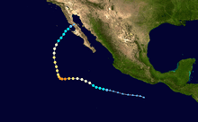
Hurricane Rosa originated from an area of disturbed weather that the National Hurricane Center (NHC) first forecasted on September 19. At that time, the NHC predicted that an areas of low pressure would form over the weekend to the south of Mexico, and begin development thereafter.[1] On September 22, a broad area of low pressure formed approximately 200 miles south of Mexico.[2] The NHC continued to track the disturbance for a few more days as it moved west to west-northwest.[3] On September 25 at 09:00 UTC, the NHC reported that Tropical Depression Twenty-E had formed approximately 365 miles (590 km) south-southwest of Manzanillo, Mexico.[4] Six hours later, the depression strengthened into a tropical storm and was assigned the name Rosa.[5]
Over the next day, Rosa continued to strengthen, becoming the tenth hurricane of the season at 15:00 UTC on September 26.[6] Rosa continued to gradually strengthen over the next eighteen hours before beginning a period of rapid intensification.[7] Rosa became a Category 2 hurricane on September 27 at 15:00 UTC and a major hurricane six hours later.[8][9] On September 28, at 03:00 UTC, Rosa peaked with maximum sustained winds of 145 mph (230 km/h) and a minimum central pressure of 940 mbar (27.76 inHg), becoming the seventh Category 4 hurricane of the season.[10] Rosa maintained this intensity for six hours before slightly weakening due to the commencement of an eyewall replacement cycle. At the same time, Rosa began to travel northwest due to an approaching mid- to upper-level trough.[11] On September 29 at 03:00 UTC, Rosa weakened into a high-end Category 2 hurricane because of the ongoing eyewall cycle and cooler sea surface temperatures.[12] At 09:00 UTC, Rosa bottomed out as a low-end Category 2 hurricane before slightly strengthening six hours later, after having completed its eyewall replacement cycle. During this time, Rosa was traveling due north under the increasing influence of the trough.[13][14] Soon after, Rosa resumed weakening, falling to Category 1 status at 09:00 UTC on September 30.[15]
Over the course of September 30, a combination of strong southwesterly wind shear, dry air entanglement, and cooler sea surface temperatures caused the core of Rosa to quickly erode resulting in the complete loss of its eye feature and convection in the south semicircle.[16][17] On October 1, at 00:00 UTC, Rosa weakened into a tropical storm.[18] At 09:00 UTC on October 2, Rosa weakened into a tropical depression due to wind shear and interactions with land, shortly before making landfall in western Baja California.[19] Six hours later, Rosa weakened into a remnant low as it began to cross into the Gulf of California.[20] From that point forward, The Weather Prediction Center (WPC) began issuing storm summaries on Rosa as it remained a major flood threat. The WPC noted that the surface low of Rosa was located in the Gulf of California while its mid-level remnants were over northeast Arizona.[21] On October 3, the remnants of Rosa were absorbed into a developing upper-level low off the coast of California.[22]
Preparations and impact
Mexico
On September 29, the Government of Mexico issued a tropical storm watch for the Pacific Coast of the Baja California peninsula from Punta Abreojos to Cabo San Quintin.[23] On the next day, the Government of Mexico changed the tropical storm watches on the west coast of Baja California to tropical storm warnings and issued watches for the east coast of Baja California from Bahia de los Angeles to San Felipe.[24] All the watches and warnings were discounted after Rosa weakened to a tropical depression.[25]
Rosa brought heavy rain and caused flash flooding in Michoacán and Sinaloa, resulting in 12 deaths and 8 missing.[26]
On October 2, a woman drowned in Caborca after being swept away by flood waters.[27] The governor of Baja California, Francisco Vega de la Madrid, issued a State of Emergency for the cities of Ensenada and Mexicali. Schools were closed on October 1 in several communities as Rosa approached the area. Classes were also suspended in the neighboring state of Sonora, as floodwaters inundated roads and highways across the state.[28]
United States
On September 30, in anticipation of severe rainfall from the remnants of Rosa, flood watches and warnings were issued for southern California, Arizona, southwest Colorado, Utah, central Nevada, and a small portion of southeast Idaho.[29] At the same time, heavy rainfall from Rosa began to affect Arizona, causing street flooding.[30] As of the final storm summary, a preliminary total of 6.89 in (175 mm) was reported at Towers Mountain, with other areas reporting 1 to 5.5 in (25 to 140 mm) of rain.[22] The National Weather Service issued a flash flood warning for the Phoenix area, as Rosa drenched the city with up to 2 inches of rainfall reported on October 2, making it one of the wettest days in the city's history. Firefighters also rescued several people from their flooded vehicles.[31] Rosa caused thousands of power outages in Yuma, Arizona.[32] On October 3, a 26-year-old French woman was killed after crossing the collapsed section of US 89 north of Cameron. Once the woman crossed the collapsed portion of the highway, she exited her vehicle to inspect for damages. She was then struck and killed by a Toyota pickup that was travelling north.[33]
At Menager Lake near Sells, Arizona, rainfall from Rosa filled the Menagers Dam above maximum capacity, raising concerns about its structural integrity.[34] This prompted the National Weather Service in Tucson to recommend immediate evacuation for the village of Ali Chuk on October 2, stating that dam failure was imminent.[35] On October 2, 162 people were evacuated from Ali Chuk, 32 from Kohatk, and 23 others from the Menegar's Dam community.[34] Despite the water level having receded, there were still concerns that the dam could fail. On October 4, the Tohono O’odham Nation announced that they were assembling an engineering team to inspect the dam before more rain arrives.[36] On the same day, a 34-year-old man was found deceased after the flooding in Golden Valley, Arizona.[37]
See also
- Other tropical cyclones named Rosa
- List of Category 4 Pacific hurricanes
- Lists of tropical cyclones by area:
- Hurricane Raymond (1989) – Category 4 hurricane that took a similar path, affected Baja California Sur as a tropical storm
- Hurricane Nora (1997) – Made landfall in Baja California as a Category 1 hurricane, and affected Arizona as a tropical storm
- Hurricane Javier (2004) – Category 4 hurricane that took a similar path, affected Baja California Sur as a tropical depression
References
- ↑ Blake, Eric. NHC Graphical Outlook Archive. National Hurricane Center (Report). National Oceanic and Atmospheric Administration. Retrieved 26 September 2018.
- ↑ Zelinsky, David. NHC Graphical Outlook Archive. National Hurricane Center (Report). National Oceanic and Atmospheric Administration. Retrieved 26 September 2018.
- ↑ Zelinsky, David. NHC Graphical Outlook Archive. National Hurricane Center (Report). National Oceanic and Atmospheric Administration. Retrieved 26 September 2018.
- ↑ Cangialosi, John. Tropical Depression Twenty-E Advisory Number 1. National Hurricane Center (Report). National Oceanic and Atmospheric Administration. Retrieved 27 September 2018.
- ↑ Pasch, Richard. Tropical Storm Rosa Advisory Number 2. National Hurricane Center (Report). National Oceanic and Atmospheric Administration. Retrieved 27 September 2018.
- ↑ Roberts, Dave. Hurricane Rosa Advisory Number 6. National Hurricane Center (Report). National Oceanic and Atmospheric Administration. Retrieved 27 September 2018.
- ↑ Avila, Lixion. Hurricane Rosa Discussion Number 9. National Hurricane Center (Report). National Oceanic and Atmospheric Administration. Retrieved 27 September 2018.
- ↑ Beven, Jack. Hurricane Rosa Advisory Number 10. National Hurricane Center (Report). National Oceanic and Atmospheric Administration. Retrieved 27 September 2018.
- ↑ Beven, Jack. Hurricane Rosa Advisory Number 11. National Hurricane Center (Report). National Oceanic and Atmospheric Administration. Retrieved 27 September 2018.
- ↑ Blake, Eric. Hurricane Rosa Advisory Number 12. National Hurricane Center (Report). National Oceanic and Atmospheric Administration. Retrieved 29 September 2018.
- ↑ Zelinsky, David. Hurricane Rosa Discussion Number 14...Corrected. National Hurricane Center (Report). National Oceanic and Atmospheric Administration. Retrieved 29 September 2018.
- ↑ Blake, Eric. Hurricane Rosa Discussion Number 16. National Hurricane Center (Report). National Oceanic and Atmospheric Administration. Retrieved 29 September 2018.
- ↑ Stewart, Stacy. Hurricane Rosa Advisory Number 17. National Hurricane Center (Report). National Oceanic and Atmospheric Administration. Retrieved 29 September 2018.
- ↑ Beven, Jack. Hurricane Rosa Advisory Number 18. National Hurricane Center (Report). National Oceanic and Atmospheric Administration. Retrieved 29 September 2018.
- ↑ Stewart, Stacy. Hurricane Rosa Advisory Number 21. National Hurricane Center (Report). National Oceanic and Atmospheric Administration. Retrieved 30 September 2018.
- ↑ Stewart, Stacy. Hurricane Rosa Discussion Number 21. National Hurricane Center (Report). National Oceanic and Atmospheric Administration. Retrieved 30 September 2018.
- ↑ Pasch, Richard. Hurricane Rosa Discussion Number 22. National Hurricane Center (Report). National Oceanic and Atmospheric Administration. Retrieved 30 September 2018.
- ↑ Berg, Robbie. Tropical Storm Rosa Intermediate Advisory Number 23A. National Hurricane Center (Report). National Oceanic and Atmospheric Administration. Retrieved 1 October 2018.
- ↑ Brown, Daniel. Tropical Depression Rosa Discussion Number 29. National Hurricane Center (Report). National Oceanic and Atmospheric Administration. Retrieved 2 October 2018.
- ↑ Cangialosi, John. Remnants Of Rosa Advisory Number 30. National Hurricane Center (Report). National Oceanic and Atmospheric Administration. Retrieved 2 October 2018.
- ↑ Otto, Richard (2 October 2018). Storm Summary Number 5 for Heavy Rainfall Associated with Rosa. Weather Prediction Center (Report). National Oceanic and Atmospheric Administration. Retrieved 2 October 2018.
- 1 2 Kong, Kwan-Yin. Storm Summary Number 7 for Heavy Rainfall Associated with Rosa. Weather Prediction Center (Report). National Oceanic and Atmospheric Administration. Retrieved 2 October 2018.
- ↑ Beven, Jack. Hurricane Rosa Advisory Number 18. National Hurricane Center (Report). National Oceanic and Atmospheric Administration. Retrieved 29 September 2018.
- ↑ Berg, Robbie. Hurricane Rosa Advisory Number 20. National Hurricane Center (Report). National Oceanic and Atmospheric Administration. Retrieved 30 September 2018.
- ↑ Brown, Daniel. Tropical Depression Rosa Advisory Number 29. National Hurricane Center (Report). National Oceanic and Atmospheric Administration. Retrieved 3 October 2018.
- ↑ "Rosa makes landfall in Mexico, threatens US southwest". Mexico City: New Indian Express. 2 October 2018. Retrieved 2 October 2018.
- ↑ Breslin, Sean. "Rosa in the Southwest: Overtaken by Floodwaters, Roads Shut Down; 1 Killed in Mexico | The Weather Channel". The Weather Channel. Retrieved 3 October 2018.
person reportedly drowned in Mexico after being swept away by floodwaters.
- ↑ Peter Orsi, Terry Tang. "Tropical Storm Rosa Heads for Baja, US Southwest". U.S News. Associated Press. Retrieved 2 October 2018.
- ↑ Tate, Jennifer. Storm Summary Number 1 for Heavy Rainfall Associated with Rosa...Corrected. Weather Prediction Center (Report). National Oceanic and Atmospheric Administration. Retrieved 2 October 2018.
- ↑ Breslin, Sean. "Rosa in the Southwest: Overtaken by Floodwaters, Roads Shut Down; 1 Killed in Mexico | The Weather Channel". The Weather Channel. Retrieved 3 October 2018.
As the floodwaters rose, some roads were closed as they became impassable, and numerous drivers had to be rescued by authorities. North of downtown Phoenix, an underpass at Interstate 17 and Peoria Avenue was shut down Tuesday morning because of flooding.
- ↑ Chaffin Mitchell. Rosa soaks Baja, southwestern US with heavy downpours. AccuWeather (Report). AccuWeather. Retrieved 2 October 2018.
- ↑ Breslin, Sean. "Rosa in the Southwest: Overtaken by Floodwaters, Roads Shut Down; 1 Killed in Mexico | The Weather Channel". The Weather Channel. Retrieved 3 October 2018.
Thousands of homes and businesses were without power across the Yuma area Sunday afternoon, according to the utility company APS.
- ↑ Devereaux, Katie (5 October 2018). "One dead after part of Highway 89 washed out". Arizona Daily Sun. Retrieved 6 October 2018.
- 1 2 "Southern Arizona dam holding as water recedes". New Haven Register. New Haven Register. Retrieved 5 October 2018.
- ↑ NWS Tucson [@NWSTucson] (October 2, 2018). "Dam failure is imminent at Menegers Lake on the Tohono O'odham Nation. Evacuation per authorities is strongly advised for the village of Ali Chuk. #azwx" (Tweet). Retrieved October 5, 2018 – via Twitter.
- ↑ Duarte, Carmen; Knott, Gloria. "Water levels drop, but tribal officials remain concerned Arizona dam could fail". Tucson.com. Tucson.com. Retrieved 5 October 2018.
- ↑ Holler, Madeleine. "MCSO: One dead in Kingman after flash flood". azfamily.com. AZFamily. Retrieved 11 October 2018.
External links
| Wikimedia Commons has media related to Hurricane Rosa (2018). |
- The National Hurricane Center's advisory archive on Hurricane Rosa
Tropical cyclones of the 2018 Pacific hurricane season | ||
|---|---|---|
 | ||
| ||
- The Weather Prediction Center's storm summary archive on Rosa
![]()