Taurida Governorate
| Taurida Governorate Таврическая губернія | ||||||
| Governorate of Russian Empire | ||||||
| ||||||
| ||||||
 | ||||||
| Capital | Simferopol | |||||
| History | ||||||
| • | Established | October 8 (old style), 1802 1802 (1783) | ||||
| • | Disestablished | 1921 | ||||
| Area | ||||||
| • | 1918 | 63,538 km2 (24,532 sq mi) | ||||
| Population | ||||||
| • | 1906 | 1,634,700 | ||||

| Part of a series on |
| Crimean Tatars |
|---|
 |
| By region or country |
| Religion |
| Languages and dialects |
| History |
| People and groups |
|
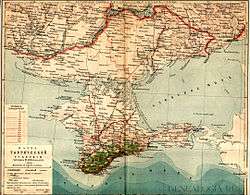
The Taurida Governorate (Russian: Таврическая губернія, modern spelling Таврическая губерния, Tavricheskaya guberniya; Ukrainian: Таврiйська губернія, Tavrijśka gubernija; Crimean Tatar: Tavrida guberniyası, Таврида губерниясы) or the Government of Taurida was an historical governorate of the Russian Empire. It included the Crimean Peninsula and the mainland between the lower Dnieper River and the coasts of the Black Sea and Sea of Azov.[1] It was formed after the Taurida Oblast was abolished in 1802 in the course of Paul I's administrative reform of the South-Western territories that had been annexed from the Crimean Khanate. The governorate's centre was the city of Simferopol. The province was named after the ancient Greek name of Crimea - Taurida.
Administrative divisions
The governorate was divided into eight counties (uyezds) and two gradonachalstva,
three of them on the mainland:
- Berdyansky Uyezd (Berdyansk – Бердянскъ)
- Dneprovsky Uyezd (centre Aleshki – Алешки)
- Melitopolsky Uyezd (Melitopol – Мелитополь)
and five in Crimea:
- Yevpatoriysky Uyezd (Yevpatoria – Евпаторiя)
- Perekopsky Uyezd (Perekop – Перекопъ)
- Simferopolsky Uyezd (Simferopol – Симферополь)
- Feodosiysky Uyezd (Feodosiya – Ѳеодосiя)
- Yaltsky Uyezd (Yalta – Ялта)
- City of Kerch (Yenikale – Керчь-Eникале)
- City of Sevastopol – Севастополь
Before 1820 the governorate consisted of seven counties that included Tmutarakan county on the Taman peninsula across the Strait of Kerch. Later were created Yalta and Berdyansk counties. In 1804–29 there also existed the gradonachalstvo of Feodosiya and in 1914 Yalta county became gradonachalstvo of Yalta.
In 1917 the governorate was split, with most of its peninsular part forming the Crimean People's Republic, less the city of Sevastopol which remained the main naval base of the Black Sea Fleet of the Russian Republic, while the rest became part of Ukrainian People's Republic.
The territory of the Ukrainian Republic was proclaimed by the Third Universal on November 20, 1917 (November 7 by Old Style)[2] of the Tsentralna Rada encompassing the Volyn Governorate, Kiev Governorate, Podolie Governorate, Chernigov Governorate, Poltava Governorate, Kharkov Governorate, Yekaterinoslav Governorate, Kherson Governorate and Taurida Governorate (not including Crimea).
Geography
The governorate bordered Yekaterinoslav Governorate and Kherson Governorate to its north. The Strait of Kerch bordered the Free lands of the Don Cossacks. It has natural borders, being surrounded by the waters of the Black Sea and the Sea of Azov.
The mainland and the peninsular parts of the region differ significantly. The total area of the governorate was 63,538 km² of which the mainland portion consisted of 38,405km² and is largely black earth steppe land. The population of the whole region was 1,634,700 in 1906. At that time, the mainland part of the governorate was mostly populated by Ukrainians and Russians but had significant ethnic minorities of Germans, Bulgarians, Armenians and Jews, while major ethnic groups of the Crimean peninsula were Crimean Tatars and Russians with German, Greek, Poles, Armenian, and Karaim minorities. Major urban centres were Simferopol, Sevastopol, Theodosia, Bakhchisaray, and Yalta in Crimea, and Aleshki, Berdyansk, and Melitopol on the mainland.[1]
Language
- The Imperial census of 1897[3] found that the population of the governorate consisted of 1,447,790, with 762,804 male and 684,986 female.
| Language | Number | Percentage (%) |
|---|---|---|
| Ukrainian | 611,121 | 42.21 |
| Russian | 404,463 | 27.94 |
| Belarusian | 9,726 | 0.67 |
| Polish | 10,112 | 0.70 |
| Czech[4] | 1,962 | 0.14 |
| Bulgarian | 41,260 | 2.85 |
| Romanian[5] | 2,259 | 0.16 |
| Italian | 1,121 | 0.08 |
| German | 78,305 | 5.41 |
| Roma | 1,433 | 0.10 |
| Yiddish | 55,418 | 3.83 |
| Greek | 18,048 | 1.25 |
| Armenian | 8,938 | 0.62 |
| Estonian | 2,210 | 0.15 |
| Tatar | 196,854 | 13.60 |
| Turkish | 2,197 | 0.15 |
| Persons that did not identify their native language |
71 | <0.01 |
| Other[6] | 2,292 | 0.16 |
In 1897 289,316 people lived in the cities, constituting 19.98% of the total population. The ethnicities of the urban population were Russians (49.1%), Tatars (17.16%), and Jews (11.84%), with only 31 people living in cities who chose not to disclose their identity.
Religion
- By the Imperial census of 1897[7] there were around 1,100,000 Eastern Orthodox followers, just over 30,000 Catholic, around 70,000 Protestant Christians and about the same number of Judaic followers. Only 13% of population were Muslims (known in the Russian Empire as Magometians) who mainly lived in the peninsular portion of the guberniya, Crimea itself. They were the main force that after the next 10 years established the first Muslim democratic state of the Crimean People's Republic. Beside the Magometians and Jews there were only eight (8) other non-Christian followers in the whole guberniya (not necessarily Atheists).
| Religion | Number | Percentage (%) |
|---|---|---|
| Eastern Orthodox | 1,069,556 | 73.88 |
| Magometians (Muslims) | 190,800 | 13.18 |
| Judaism (Krymchaks, Subbotniks) | 60,752 | 4.20 |
| Lutherans | 42,654 | 2.95 |
| Roman Catholics | 29,393 | 2.03 |
| Menonites | 25,508 | 1.76 |
| Old Believers | 13,724 | 0.95 |
| Armenian-Gregorians | 7,494 | 0.52 |
| Qārāʾîm | 6,166 | 0.43 |
| Armenian-Catholics | 1,206 | 0.08 |
| Other[8] (Reformators, Anglicans, Baptists, others) | 537 | 0.04 |
History
- For further history see: History of Crimea
In 1783, the Khanate of Crimea was annexed by Catherine the Great’s Russia. Soon after this the Taurida Oblast was established. During the reign of Paul I the oblast was abolished, but soon (in 1802) re-established as a governorate (guberniya). It was a part of the Russian Empire until the Russian Revolution of 1918.
Following the 1917 October Revolution, the ethnic Tatar government proclaimed the Crimean People's Republic on December 13, 1917, which was the first Muslim Democratic state. The Tatar republic covered the peninsular portion of the former governorate, while its northern counties ended up temporarily under jurisdiction of the Yekaterinoslav Governorate. However neither Ukraine nor the Crimea managed to hold on to their territories and were overrun by Bolshevik Red Guards in the winter of 1917-18. Briefly in early 1918 the bolsheviks split the governorate territories between the Taurida Soviet Socialist Republic and the Donetsk-Krivoi Rog Soviet Republic before being overrun by the forces of the Ukrainian People's Republic with military assistance from the German Empire.
References
- 1 2

- ↑ The Third Universal in the archives of the Verkhovna Rada (in Ukrainian)
- ↑ Language Statistics of 1897 (in Russian)
- ↑ including Slovakian language
- ↑ including Moldavian language
- ↑ languages, number of speakers which in all gubernia were less than 1,000
- ↑ Religion Statistics of 1897 (in Russian)
- ↑ Religions, number of believers which in all gubernia were less than 1,000
Further reading
- William Henry Beable (1919), "Governments or Provinces of the Former Russian Empire: Taurida", Russian Gazetteer and Guide, London: Russian Outlook – via Open Library