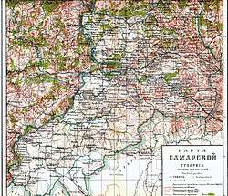
Samara Governorate
| Samara Governorate Самарская губерния | |||||
| Governorate of the Russian Empire | |||||
| |||||
.png) | |||||
 | |||||
| Capital | Samara | ||||
| History | |||||
| • | Established | 1851 | |||
| • | Disestablished | 14 May 1928 | |||
| Population | |||||
| • | 1897 | 2,751,336 | |||
Samara Governorate (Russian: Самарская губерния) was an administrative division (a guberniya) of the Russian Empire, located in the Volga Region. It existed from 1851 to 1928; its seat was in the city of Samara.[1]
Administrative divisions
The governorate was divided into seven uyezds (counties). These were:[1]
- Bugulminsky Uyezd
- Buguruslansky Uyezd
- Buzuluksky Uyezd
- Nikolayevsky Uyezd
- Novouzensky Uyezd
- Samarsky Uyezd
- Stavropolsky Uyezd
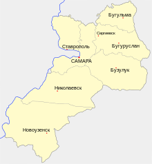
Map of the administrative divisions of the governorate, to 1918
References
- 1 2 "Самарская губерния" [Samara Governorate]. Brockhaus and Efron Encyclopedic Dictionary (in Russian). St. Petersburg. 1900.
This article is issued from
Wikipedia.
The text is licensed under Creative Commons - Attribution - Sharealike.
Additional terms may apply for the media files.