Baku Governorate
| Baku Governorate (in English) | ||
|---|---|---|
| ||
 | ||
| ||
| Established |
1846 as Shemakha Governorate; renamed to Baku Governorate in 1859 | |
| Abolished | 1917 | |
| Political status | Governorate | |
| Region | Caucasus Viceroyalty | |
| Area | 34,400 verst² | |
| Population (1897 census) | ||
| • Total | 789659 | |
| • Density | 23 inhab. / verst² | |
| • Urban | 19.80% | |
| • Rural | 80.20% | |
| Government | ||
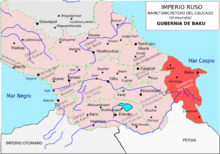
Baku Governorate (Russian: Бакинская губерния, Pre-Reform Russian: Бакинская губернія) was one of the guberniyas of the Caucasus Viceroyalty of the Russian Empire, with its centre in Baku. Area (1897): 34,4000 sq. versts, population (1897): 789,659.[1] The only foreign border of the governorate was Persia, in the south. Within the empire it bordered with Elisabethpol Governorate (Tiflis and Erivan Governorates before 1868) and Dagestan Oblast.
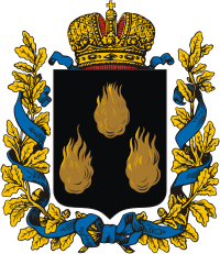
The governorate was established in 1846 as Shemakha Governorate, in place of several military precincts. In 1849 Shahur-Daralagoz uzeyd was part of newly founded Erivan Governorate. After the devastating 1859 Shamakhi earthquake it was decided to transfter the capital of the governorate from Shemakha to Baku. On July 12, 1859 the governorate's name was changed accordingly. The coat of arms of the governorate was instituted on July 5, 1878. Initially Baku Governorate included Karabakh and Zangezur, which were separated in 1868 to create Elisabethpol Governorate.
The governorate was preserved until the establishment of the Azerbaijan Democratic Republic, when it was split into Baku Governorate and Lankaran General-Governorate.
Administrative division
Baku Governorate had six uyezds (in 1868 Nukha and Shusha uyezds were attached to Elisabethpol Governorate):
- Baku
- Kuba (attached in 1860)
- Shemakha
- Geokchai
- Dzhevat
- Lenkoran
Demographics
As of 1897, 789,659 people populated the governorate, of them 55% were male. Azeris (then-known as Caucasian Tatars, mostly Shiite) constituted the majority of the population. Significant minorities consisted of Russians, Armenians, Lezgins, Tats, Talysh and Jews.[1]
Ethnic groups in 1897[2]
| Uyezd | Azerbaijani Tatars |
Tats | Russians | Armenians | Laks | Talysh people | Lezgins | Germans | Persian | Jews | Avars |
|---|---|---|---|---|---|---|---|---|---|---|---|
| TOTAL | 58,7% | 10,8% | 8,9% | 6,3% | 5,8% | 4,2% | 1,4% | ... | ... | ... | ... |
| Baku | 34,7% | 18,9% | 24,0% | 12,3% | ... | ... | ... | 1,8% | 2,6% | 1,1% | ... |
| Geokchay | 79,0% | 3,4% | 2,1% | 11,0% | 1,7% | ... | ... | ... | ... | ... | 1,5% |
| Dzhevat | 93,3% | ... | 4,5% | ... | ... | ... | ... | ... | ... | ... | ... |
| Kuba | 38,3% | 25,3% | 1,4% | ... | 24,4% | ... | 6,3% | ... | ... | 2,2% | ... |
| Lenkoran | 64,7% | ... | 7,2% | ... | ... | 26,7% | ... | ... | ... | ... | ... |
| Shemakh | 73,7% | 3,7% | 9,3% | 11,7% | ... | ... | ... | ... | ... | ... | ... |
Ethnic groups at the start of the 20th century
The ethnic group composition was notable different as compared to several decades earlier. At the beginning of the 20th century in Baku, it had 214,700 inhabitants, amongst them Russians, Ukrainians and Belarusians - 76,3 thousand -> (35.5%), Azerbaijanis ("Caucasian Tatars" back then) - 46 thousand -> (21.4%), Armenians - 42 thousand -> (19.4%), Persians\Iranians - 25 thousand -> (11.7%), Jews - 9,7 thousand -> (4.5%), Georgians - 4 thousand -> (1, 9%), Germans - 3.3 thousand -> (1.5%), the Kazan Tatars - 2.3 thousand -> (1.1%).[3] Muslims generally lived in the historical center (Old Baku), surrounded by the khan's castle in the west of the city. In the industrial zone lived the Armenians - in the north of the city. During the construction of the new city center, various ethnic groups started to live in different districts.[4]
Known governors
- Konstantin Tarkhanov-Mouravov, 1859–1863
- Mikhail Kolyubakin, 1863–1872
- Dmitry Staroselsky, 1872–1875
- Valery Pozen, 1875–1882
- Justin von Huebsch Grostal, 1882–1888
- Vladimir Rogge, 1888–1899
- Dmitry Odintsov, 1899–1904
- Mikhail Nakashidze, 1904–1905
- Andrei Fadeyev, 1905
- Vladimir Alyshevsky, 1905–1915
- Leo Potulov, 1916–1917[5]
References
- 1 2 (in Russian) ЭСБЕ/Баку. Brockhaus and Efron Encyclopedic Dictionary. Retrieved 5 June 2016.
- ↑ Демоскоп Weekly - Первая всеобщая перепись населения Российской Империи 1897 г. Распределение населения по родному языку и уездам. Российской Империи кроме губерний Европейской России
- ↑ Современный Азербайджан. // Новый Восток. 1926. № 4. С. 174
- ↑ Йорг Баберовски. (2004). Под ред. И. Герасимова,, ed. "Цивилизаторская миссия и национализм в Закавказье: 1828-1914 гг". Новая имперская история постсоветского пространства. Казань: New Imperial History: 322. ISBN 9785852470249.
- ↑ Baku Lands Archived 2011-04-26 at the Wayback Machine.
External links
