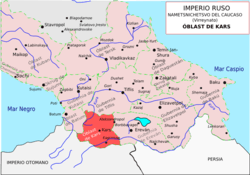
Kars Oblast
| Kars Oblast Карсская область | |||||
| Oblast of Russian Empire | |||||
| |||||
 | |||||
 | |||||
| Capital | Kars | ||||
| History | |||||
| • | Treaty of San Stefano | 1878 | |||
| • | First Republic of Armenia | 1918 | |||
| Area | |||||
| • | 1897 | 16,473 km2 (6,360 sq mi) | |||
| Population | |||||
| • | 1897 | 290,654 | |||
| Density | 17.6 /km2 (45.7 /sq mi) | ||||
| Today part of | Kars Province Ardahan Province Erzurum Province | ||||
Kars Oblast (Russian: Карсская область, Karsskaya Oblast) was one of the oblasts of the Caucasus Viceroyalty of the Russian Empire between 1878 and 1917. Its capital was the city of Kars, presently in the Republic of Turkey. The governorate bordered with the Ottoman Empire, Batum Oblast, Tiflis Governorate, Erivan Governorate, and from 1883 to 1903 the Kutais Governorate. It covered all of Turkey's present provinces of Kars and Ardahan and the northeastern part of Erzurum Province as well as a small part of Armenia.
History
Kars Oblast was created in 1878 from some of the lands conquered by Russia from the Ottoman Empire and transferred to Russia by the Treaty of San Stefano (1878). The lands of the Oblast had previously belonged to the Ottoman Kars Eyalet and Samtskhe Province before 1845 and Erzurum Eyalet after 1845. [1]
With the incorporation of the region into Russian Empire, a large portion (82,000 during 1878-81, according to Russian sources[1]) of the local Muslim population left for Ottoman territory. Instead new settlers (mostly Armenians, Caucasus Greeks (i.e., Russianized, eastern Pontic Greeks from Armenia and Georgia) and Russians)[1] migrated to or were resettled in the newly conquered lands from Russia's other Transcaucasian provinces or from areas that still fell within the Ottoman Turkish side of the newly drawn border. Russian Imperial Census of 1897 clearly reflected the new ethnic composition.
Russian official population statistics based on the native language of respondents, 1897.
| Language Groups | Kars Oblast | % |
| Armenian | 73,406 | 25.3 |
| Turkish | 63,547 | 21.9 |
| Kurdish | 42,968 | 14.8 |
| Greek | 32,593 | 11.2 |
| Karapapak | 29,879 | 10.3 |
| Russian | 27,856 | 9.6 |
| Turkmen | 8,442 | 2.9 |
| Polish | 3,243 | 1.1 |
| Tatar | 2,347 | 0.8 |
| Other languages | 6,373 | 2.1 |
| TOTAL | 290,654 | 100 |
Many of these Christian Orthodox communities had fought in or collaborated with the Russian Imperial Army as a means of recapturing territory from the Muslim Ottomans for Christian Orthodoxy.[1]
The first ruler of the oblast held the title of nachalnik ("chief"), later the title became military governor. Nachalniks were Ivan Popko (Russian: Попко, Иван Диомидович) between 01.11.1877 and 08.06.1878, and Viktor Frankini (Russian: Франкини, Виктор Антонович), between 08.06.1878 and 27.10.1878. The first military governor was Viktor Frankini (27.10.1878—01.04.1881).
After the October Revolution of 1917 and the disintegration of Russian Empire, the lands of Kars Oblast were controlled for a short while by First Republic of Armenia and, in its northeastern part, by the Democratic Republic of Georgia. Eventually, Turkish forces recovered the region, leading to a formation of an unrecognized provisional government, before the lands gained by the First Republic of Armenia were maintained. Incorporation of most of the lands of the former Kars Oblast into Turkey was confirmed by the borders determined in the Treaty of Kars (1921), signed by proclaimed Turkish Government, Armenia SSR, Azerbaijan SSR and Georgia SSR.
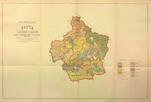
Administrative division
Since 1881, Kars Oblast consisted of four okrugs (districts):
- Kars (Карсский округ)
- Ardahan (Ардаганский округ)
- Kaghzvan (Кагызманский округ)
- Oltu (Ольтинский округ)
Two more okrugs, Zarushat (Заришат) and Shoragyal (Шорагял; also spelt Shuregel) existed in 1878-81.
Demographics
1892
.jpg)
In 1892, the population of Kars Oblast was estimated as 200,868. The ethnic composition, and religious affiliation of ethnic groups, was reported as follows:[1]
- Turks (this number also included a some Adjarians): 24% (Sunni Muslims)
- Armenians: 21.5%
- Kurds: 15%
- Muslim Karapapaks: 14% (Sunni and some Shi'a)
- Alevi Karapapaks (reported as 'Turkmen'): 5%
- Yazidis
- Caucasus Greeks or eastern Pontic Greeks from Georgia and northeastern Anatolia: 13.5% (Orthodox Christians)
- Russians: 7% (mostly "sectarians", i.e. Spiritual Christian Pryguny, Molokans, Doukhobors, etc.)
The religious composition of the population was reported as follows:
- Orthodox Christians: 14%
- Spiritual Christians (Pryguny, Molokans, Doukhobors, etc.): 5%
- Armenian Apostolic Church: 21%
- Other Christian churches: 0.75%
- Muslims: 53%, among which:
- Alevi (reported as "Ali Illahi"): 5%
- Yazidism: 1.25%
1897

The Russian Empire Census of 1897 counted 290,654 residents in Kars Oblast, including 160,571 men and 130,083 women. This number may perhaps imply that the 200,868 estimate for 1892 given by Brockhaus is too low, or that a large-scale migration from other provinces of the empire took place in between. The following breakdown of the population by the mother tongue was reported:[2]
- Turkic: 104,457, including:
- Armenian: 73,406
- Kurdish: 42,968
- Caucasus Greeks: 32,593
- East Slavic: 27,856, including:
- Russian: 22,327
- Ukrainian: 5,279
- Belarusian: 250
- Polish: 3243
- Jewish (Yiddish etc.): 1,138
- Lithuanian: 892
- Chaldean Neo-Aramaic ('Assyrian'): 585
- Persian: 568
- Georgian: 543
- Ossetian: 520
- Estonian: 455
- Lezgin: 448
- German: 430
The 30,000 excess population of male over females was mainly attributed to the "European" ethnic groups. Viz., among the 27,856 speakers of Russian, Ukrainian, and Belarusian, 19,910 men and 7,946 women were recorded. The Polish, and Lithuanian speakers were almost exclusively (99%) male as well; Germans and Jews, 80 to 90% males. This preponderance of males in the "European" ethnic groups (reported, usually to a lesser extent, in neighboring governorates as well) may indicate presence of a large numbers of soldiers or exiled persons in the region.
Ethnic groups in Kars Oblast according to 1897 Russian census[3]
| Okrug (district) | Armenians | Turks | Kurds | Caucasus Greeks | Karapapak | Russians | Turkmens | Ukrainians | Poles | Tatars (Azerbaijani) |
|---|---|---|---|---|---|---|---|---|---|---|
| TOTAL | 25,3% | 21,9% | 14,8% | 11,2% | 10,3% | 7,7% | 2,9% | 1,8% | 1,1% | … |
| Ardahan | 2,9% | 42,6% | 19,1% | 11,9% | 12,0% | 3,0% | 6,6% | … | … | … |
| Kaghizman | 36,5% | 8,7% | 29,9% | 12,2% | … | 4,4% | 1,1% | 2,4% | 1,5% | 1,5% |
| Kars | 34,8% | 7,9% | 6,8% | 11,0% | 16,4% | 12,6% | 1,8% | 2,5% | 1,6% | 1,1% |
| Olti | 9,9% | 62,6% | 11,1% | 8,6% | … | 2,8% | 3,2% | … | … | … |
See also
References
- 1 2 3 4 5 Карсская область (Kars Oblast) in Brockhaus and Efron Encyclopedic Dictionary (in Russian)
- ↑ Первая всеобщая перепись населения Российской Империи 1897 г. Распределение населения по родному языку и регионам (Census 1897)
- ↑ Демоскоп Weely - Первая всеобщая перепись населения Российской Империи 1897 г. Распределение населения по родному языку и уездам. Российской Империи кроме губерний Европейской России