Kazan Governorate
| Kazan Governorate (in English) | ||
|---|---|---|
| ||
| ||
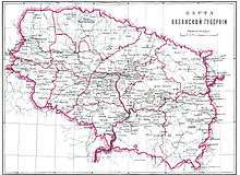 Kazan Governorate in the late 19th century | ||
| ||
| Established | 1708 | |
| Abolished | 1920 | |
| Political status | Governorate | |
| Region | European Russia | |
| Area | 55,900 verst² | |
| Population (1913 census) | ||
| • Total | 2850000 | |
| • Density | 51 inhab. / verst² | |
| Government | ||
.png)
The Kazan Governorate (Russian: Каза́нская губе́рния; Tatar: Cyrillic Казан губернасы, Latin Qazan ğubernası, Arabic قازان عوبئرناسئ; Chuvash: Хусан кӗперниӗ, Husan kĕperniĕ), or the Government of Kazan, was a governorate (a guberniya) of the Tsardom of Russia, the Russian Empire, and the Russian SFSR from 1708–1920, with its seat in the city of Kazan.
History
Part of a series on the |
|---|
| History of Tatarstan |
 |
Part of a series on the |
|---|
| History of Udmurtia |
 |
Kazan Governorate, together with seven other governorates, was established on December 29 [O.S. December 18], 1708, by Tsar Peter the Great's edict[1] on the lands of the Khanates of Kazan, Sibir, and Astrakhan, with addition of some lands from the Nogai Horde. These were the areas historically governed by the Kazan Palace's Prikaz. As with the rest of the governorates, neither the borders nor internal subdivisions of Kazan Governorate were defined; instead, the territory was defined as a set of cities and the lands adjacent to those cities.[2]
In 1717, Astrakhan Governorate was separated from Kazan Governorate; in 1719—Nizhny Novgorod; in 1744—Orenburg; in 1781—Vyatka, Simbirsk, and Ufa Governorates were separated. Under Catherine the Great (1781–1796) Kazan was the center of a namestnichestvo (viceroyalty), with Kazan, Penza, and Saratov Governorates as its integral parts.
At first the governorate was divided into lots (доли, doli), then into provinces (провинции, provintsii) in 1719, and into uyezds (уезды) in 1775. Prior to 1796, there were Kazan, Kozmodemyansk, Laishev, Mamadysh, Sviyazhsk, Spassk, Tetyushi, Tsaryovokokshaysk, Tsivilsk, Cheboksary, Chistopol, and Yadrin uyezds.
In 1913, the area of the governorate comprised 55,900 square versts, its population was estimated at 2.85 million (38.9% Russians, 31.2% Tatars, 22.8% Chuvash, 5.1% Mari, 1.2% Mordva). There were 7,272 settlements, including 13 towns: Kazan, Arsk, Sviyazhsk, Kozmodemyansk, Laishev, Mamadysh, Spassk, Tetyushi, Tsaryovokokshaysk, Tsivilsk, Cheboksary, Chistopol, Yadrin; and two posads: Mariinsky Posad and Troitsky Posad.
The governorate was finally abolished during the Bolshevik administrative reform (see Idel-Ural State). Thereupon its Eastern part was proclaimed the Tatar ASSR, while the Western part was eventually divided between Chuvashia and Mari El.
External links
Main events in the governorate
- 1774 Pugachev rebellion
- 1861 Biznä Unrest
- 1880s Wäisi movement
References
- ↑ Указ об учреждении губерний и о росписании к ним городов (in Russian)
- ↑ С. А. Тархов (2001). "Изменение административно-территориального деления России за последние 300 лет". Электронная версия журнала "География". Archived from the original on November 13, 2013.
Further reading
- William Henry Beable (1919), "Governments or Provinces of the Former Russian Empire: Kazan", Russian Gazetteer and Guide, London: Russian Outlook – via Open Library