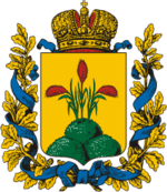
Mogilev Governorate
| Mogilev Governorate (in English) | ||
|---|---|---|
| ||
| ||
 Belarusian Governorates in 1882 maps | ||
| ||
| Established | 1772 | |
| Abolished | 1919 | |
| Political status | Governorate | |
| Region | European Russia | |
| Area | 42,134.6 verst² | |
| Population (1897 census) | ||
| • Total | 1686764 | |
| • Density | 40 inhab. / verst² | |
| Government | ||
The Mogilev Governorate (Mogilevskaya Gubernya) or Government of Mogilev was a governorate (guberniya) of the Russian Empire in the territory of the present day Belarus. Its capital was in Mogilev, referred to as Mogilev-on-the-Dnieper, or Mogilev Gubernskiy.[1]
The area of the governorate was inhabited in the 10th century by the Slav tribes of the Krivichi and Radimichi. In the 14th century, the land became part of Lithuania, and later Poland.[1] The governorate was formed in 1772, in the aftermath of the First partition of Poland, from parts of the voivodeships of Witebsk, Mścisław, Połock and Inflanty. Parts of these territories were also used to form the Pskov Governorate. In 1796, Mogilev and Polotsk Governorates were united and formed Belorussian Governorate. In 1802, Belorussian Governorate was divided into Vitebsk Governorate and Mogilev Governorate. In 1917, Vitebsk, Mogilev and parts of Minsk Governorate and Vilna Governorate were united into the Western District (from 1918 known as Western Komuna). In 1918, it was joined by Smolensk Governorate and in October 1919, Mogilev Governorate was reformed into Gomel Governorate.[2]
References
- 1 2

- ↑ http://www.jewishgen.org/Belarus/grodno/distcent.htm
External links
Coordinates: 53°55′00″N 30°21′00″E / 53.9167°N 30.3500°E
