LaPlace, Louisiana
| LaPlace, Louisiana | |
| Census-designated place | |
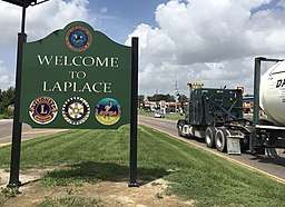 U.S. Highway 61 (Airline Highway) at U.S. Highway 51 intersection in LaPlace | |
| Country | United States |
|---|---|
| State | Louisiana |
| Parish | St. John the Baptist |
| Elevation | 10 ft (3.0 m) |
| Coordinates | 30°04′30″N 90°29′06″W / 30.07500°N 90.48500°WCoordinates: 30°04′30″N 90°29′06″W / 30.07500°N 90.48500°W |
| Area | 22.7 sq mi (58.8 km2) |
| - land | 21.5 sq mi (56 km2) |
| - water | 1.2 sq mi (3 km2), 5.29% |
| Population | 32,134 (2010) |
| Density | 1,287.8/sq mi (497.2/km2) |
| Timezone | CST (UTC-6) |
| - summer (DST) | CDT (UTC-5) |
| ZIP code | 70068 |
| Area code | 985 |
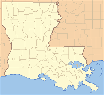 Location of La Place in Louisiana | |
 Location of Louisiana in the United States | |
| Website: http://sjbparish.com/government_index.php | |
LaPlace ( /lə
LaPlace is the southern terminus of Interstate 55, where it joins with Interstate 10, and of US 51, where it terminates at the junction with US 61. LaPlace is located 25 miles (40 km) west of New Orleans.
History
Pre-European
The Chitimacha lived in the region prior to the arrival of European colonists. The tribe’s lands once encompassed the entire Atchafalaya Basin, westward to Lafayette, Louisiana, southward to the Gulf of Mexico and eastward to the New Orleans area. The Chitimacha Tribe currently resides on a reservation in St. Mary Parish, Louisiana.
European colonization
Present-day LaPlace was settled by German immigrants in the early 18th century during Louisiana's French colonial period, as part of a larger settlement on the bank of the Mississippi called Karlstein.[1] Karlstein was one of the four settlements collectively known as the "German Coast" (French: "La Côte des Allemands"), having been populated by German-speaking immigrants since 1721.[2] French and Acadians intermarried with the Germans, and the area came to be known as Bonnet Carré (English: "square bonnet").[1][2] The name Bonnet Carré was inspired by the right-angle turn of the Mississippi river near the settlement and its resemblance to a square bonnet.[3]
1811 Slave Revolt
Manual Andry built Woodland plantation in 1793, and cultivated sugarcane.[4] The crop was lucrative if brutal methods were used, as had been common in Haiti (and had led to a successful slave rebellion there). In early January 1811, slaves at Woodland Plantation and several nearby plantations attempted the German Coast Uprising.[5] A group of 200-500 slaves armed with guns, axes, and cane knives set out from LaPlace to conquer New Orleans and gain freedom for themselves and others.[6] Local white "militia" men crushed the rebellion within three days, and nearly 100 slaves were either killed in battle, slaughtered by pursuing militia, or executed after summary trials by planter tribunals.[6] Although more slaves may have participated in the Black Seminole rebellion in 1836 and the whole of the Second Seminole War, this is now considered the largest slave rebellion.[7][8]
Post-Civil War developments
In 1879, pharmacist, planter, and patent medicine purveyor[9] Basile Laplace arrived from New Orleans, and established a large plantation in Bonnet Carré. In 1883 he allowed the New Orleans and Baton Rouge Railroad to cut through his land.[1][9] The settlement's railroad depot was named after Laplace, then the post office, and eventually the town itself.[1][3]
In the 1920s, Woodland Plantation was bought by the Montegut family, but the most famous person born there may have been Kid Ory, who was born in an outbuilding and later led a successful New Orleans jazz band.[4]
Weather events
In the period between 1850 and 1883, the levee on the east bank of the Mississippi flooded several times.[10] In 1850, a flood created the Bonnet Carré Crevasse, a levee breach that was more than a mile wide.[10] Several major floods were exacerbated by this crevasse near LaPlace and one resulted in severe flooding of New Orleans in 1871.[10] The breach was closed in 1883.[10]
In 2012, about 5,000 houses were damaged by flooding in LaPlace during Hurricane Isaac.[11]
In February 2016 and again in March 2016, several tornadoes made landfall in LaPlace, damaging hundreds of buildings and disrupting power.[12][13]
Spelling
Despite the spelling used for LaPlace's namesake, the St. John the Baptist Parish Police Jury decreed in 1971 that the official spelling of the town includes a capital letter "P".[14]
Andouille
Andouille, a smoked pork sausage that originated in France, is popular in LaPlace and elsewhere in Louisiana, but in the 1970s then-Governor Edwin Edwards proclaimed LaPlace the "Official Andouille Capital of the World".[15] Since 1972, LaPlace has held an Andouille Festival every October.[15] On his program Feasting on Asphalt, TV chef Alton Brown visited LaPlace to sample its andouille.[16]
Industry
The Port of South Louisiana is headquartered in LaPlace.[17] Other major employers in the region include Shell Chemical Company, DuPont, ADM Growmark, and ArcelorMittal (formerly Bayou Steel).[18]
Geography
LaPlace is located at 30°4′30″N 90°29′6″W / 30.07500°N 90.48500°W (30.075025, -90.484896)[19] and has an elevation of 10 feet (3.0 m)Template:GR3.
According to the United States Census Bureau, the CDP has a total area of 22.7 square miles (59 km2), of which 21.5 square miles (56 km2) is land and 1.2 square miles (3.1 km2) (5.29%) is water.
Demographics
As of the census[20] of 2010, there were 29,872 people, 11,159 households, and 10,592 families residing in the CDP. The population density was 1,287.8 people per square mile (497.2/km²). There were 9,888 housing units at an average density of 460.0 per square mile (177.6/km²). The racial makeup of the CDP was 47.0% White, 47.9% African American, 0.4% Native American, 1.0% Asian, 0.1% Pacific Islander, 1.11% from other races, and 1.17% from two or more races. The cultural groups for Hispanic or Latino, of any race, were 6.1% of the population.
There were 9,171 households out of which 44.9% had children under the age of 18 living with them, 60.4% were married couples living together, 14.9% had a female householder with no husband present, and 20.0% were non-families. 16.4% of all households were made up of individuals and 4.9% had someone living alone who was 65 years of age or older. The average household size was 2.97 and the average family size was 3.34.
In the CDP, the population was spread out with 31.2% under the age of 18, 9.4% from 18 to 24, 31.6% from 25 to 44, 21.3% from 45 to 64, and 6.5% who were 65 years of age or older. The median age was 32 years. For every 100 females, there were 96.6 males. For every 100 females age 18 and over, there were 93.8 males.
The median income for a household in the CDP was $45,103, and the median income for a family was $50,024. Males had a median income of $39,304 versus $23,277 for females. The per capita income for the CDP was $17,090. About 9.9% of families and 12.1% of the population were below the poverty line, including 15.4% of those under age 18 and 13.0% of those age 65 or over.
Education
Public schools[21]
The St. John the Baptist Parish School Board operates public schools in LaPlace.
- East St. John Elementary School
- Emily C Watkins Elementary School
- Glade Elementary School
- John L. Ory Communications Magnet Elementary School
- Laplace Elementary School
- St. John Special Education
Private and parochial schools[21]
- Ascension of Our Lord School
- Liberty Christian Academy
- Riverside Academy
- Saint Charles Catholic High School
- St. Joan of Arc Catholic School
List of movie and television appearances
- The Academy Award-winning movie Monster's Ball, starring Halle Berry and Billy Bob Thornton.
- The television series Memphis Beat.
- Various scenes of the WWE Studios movie Knucklehead.
- The Old Airline Motors Diner on Airline Highway in LaPlace doubled as an IHOP in the movie Glory Road.
- The Jonas Brothers music video "Pom Poms" featured the Joe Keller Memorial Stadium in nearby Reserve, Louisiana.
Notable people
- A. J. Duhe, Louisiana State University alumnus, former linebacker for the Miami Dolphins
- Robert Faucheux, attorney and state representative from 1996 to 2004[22]
- Randal Gaines, attorney and Louisiana State Representative for St. Charles and St. John the Baptist parishes since 2012
- Louis Lipps, former wide receiver for the Pittsburgh Steelers and the New Orleans Saints
- Chris Markey, former running back for the UCLA Bruins
- Damon Mason, defensive back and coach in the Arena Football League
- Nickie Monica, businessman, former parish president and former state representative
- Edward "Kid" Ory, trombonist and bandleader
- DeQuincy Scott, football player
- Ian Villafana, guitarist
- Felix Simoneaux Jr., supercentenarian, oldest man in the United States from January 18 to April 19, 2016
Media
Cable and Internet services in LaPlace are provided by Reserve Telecommunications.
See also
| Wikimedia Commons has media related to LaPlace, Louisiana. |
References
- 1 2 3 4 Sternberg, Mary Ann (2013-04-15). Along the River Road: Past and Present on Louisiana's Historic Byway. LSU Press. ISBN 9780807150627.
- 1 2 C, Merrill, Ellen (2014-11-30). Germans of Louisiana. Pelican Publishing. ISBN 9781455604845.
- 1 2 Leeper, Clare D'Artois (2012-10-19). Louisiana Place Names: Popular, Unusual, and Forgotten Stories of Towns, Cities, Plantations, Bayous, and Even Some Cemeteries. LSU Press. ISBN 9780807147382.
- 1 2 dhasselle@theadvocate.com, DELLA HASSELLE. "For sale: Plantation built in 1793, untouched since '04, complete with rich history, original beams, fireplaces". theadvocate.com.
- ↑ Loewen, James W. (2010-09-07). Lies Across America: What Our Historic Sites Get Wrong. The New Press. ISBN 9781595586766.
- 1 2 Rasmussen, Daniel (2011-01-04). American Uprising: The Untold Story of America's Largest Slave Revolt. Harper Collins. ISBN 9780062084354.
- ↑ Perkins, Andrea (2014-02-11). "The forgotten rebellion of the Black Seminole Nation". People's World. Retrieved 2017-08-21.
- ↑ Fessenden, Marissa. "How a Nearly Successful Slave Revolt Was Intentionally Lost to History". smithsonianmag.com.
- 1 2 "LaPlace: More to the Andouille Capital than you probably know". NOLA.com. Retrieved 2017-08-21.
- 1 2 3 4 Historic Names and Places on the Lower Mississippi River. USACE, Vicksburg District. 1977-06-01.
- ↑ "Hurricane Isaac floodwaters take LaPlace and Slidell by surprise". NOLA.com. Retrieved 2017-08-21.
- ↑ "Here is the latest on the LaPlace tornado damage". NOLA.com. Retrieved 2017-08-21.
- ↑ Advocate, The. "Photos: Tornadoes leave jaw-dropping destruction in LaPlace". The Advocate. Retrieved 2017-08-21.
- ↑ I-10 Reserve Relief Canal Turnaround and Interchange, St.John the Baptist Parish: Environmental Impact Statement. 1977.
- 1 2 "Why is LaPlace the andouille capital of the world?". WGNO. 2016-10-14. Retrieved 2017-08-21.
- ↑ Cook, Phaedra (2016-03-28). "Family, Feasting, Asphalt and Inspiration — Or, Me and Mr. Brown". Houston Press. Retrieved 2017-08-21.
- ↑ Wilds, John; Dufour, Charles L.; Cowan, Walter G. (1996-07-01). Louisiana, Yesterday and Today: A Historical Guide to the State. LSU Press. ISBN 9780807118931.
- ↑ Daigle, Charles. "St. John the Baptist Parish". www.sjbparish.com. Retrieved 2017-08-21.
- ↑ "US Gazetteer files: 2010, 2000, and 1990". United States Census Bureau. 2011-02-12. Retrieved 2011-04-23.
- ↑ "American FactFinder". United States Census Bureau. Retrieved 2008-01-31.
- 1 2 "High Schools - LaPlace, LA - NOLA.com". NOLA.com. Retrieved 2017-08-21.
- ↑ "Louisiana: Faucheux, Robert R. (Bobby)", Who's Who in American Politics, 2003-2004, 19th ed., Vol. 1 (Alabama-Montana) (Marquis Who's Who: New Providence, New Jersey, 2003), p. 778
Municipalities and communities of St. John the Baptist Parish, Louisiana, United States | ||
|---|---|---|
| CDPs | 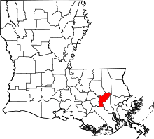 | |
| Unincorporated communities | ||
| Ghost town | ||
| Footnotes | ‡This populated place also has portions in an adjacent parish | |